
Trier-Kürenz
|
Short term
District of Trier
Coordinates: 49 ° 46 ′ 0 ″ N , 6 ° 40 ′ 0 ″ E
|
|
|---|---|
| Height : | 170 m above sea level NHN |
| Area : | 5.83 km² |
| Residents : | 8708 (Dec. 31, 2009) |
| Population density : | 1,495 inhabitants / km² |
| Incorporation : | 1930 |
| Area code : | 0651 |
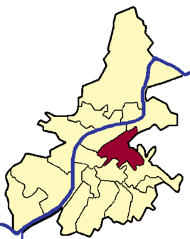  Location in the city of Trier
|
|


Kürenz is one of the 19 districts of the city of Trier in Rhineland-Palatinate .
geography

Kürenz consists of the historic districts of Neu- and Alt-Kürenz, is located east of the city center and extends over an area of 582.5 hectares in both the Moselle valley and the Avelertal valley to the high Petrisberg plateau. 8,708 inhabitants live in the district as of 2009.
New Kürenz
The Neu-Kürenz area stretches from the Avelsbacher Tal to the Petrisberg plateau and the new Weidengraben settlement that was built in 1963. It borders on the grounds of the University of Trier , which moved to its new location in the high-altitude districts in 1977. It is already in the district of Trier-Tarforst . In 2004 a roundabout was integrated into the Kohlenstraße to enable a connection to the state horticultural show on the Petrisberg. On the former site of the French military, where the state horticultural show took place, another new building area was built after the exhibition closed.
- In the Avelertal
The Avelertal is a river valley ( Avelsbach ), which flows into the Moselle valley in Alt-Kürenz. It is located between the Petrisberg plateau and the Grüneberg , which takes its name from the greenish diabase that occurs.
Only the south-western side (Petrisberg slope) of the road is fully built up. There are only a few buildings on the opposite side. The street was expanded in the 1960s and is a main connection between Trier city center and the high-altitude districts and the surrounding communities.
The Kolonnenweg branches off on the Grüneberg to the Defense Technical Center for Vehicles and Tanks (WTD 41) of the Bundeswehr . At the level of the confluence, a cycling and hiking path begins, which extends from there through the entire Avelertal to Tarforst.
At the level of the Weidengraben housing estate in the Avelertal is the Trier state wine-growing domain , which also owns most of the vineyard slopes in the Avelertal.

- Willow moat

The Weidengraben is a new housing estate from the 1960s. It extends along the coal road and flows into it at two points. The settlement is at an altitude of 260 meters above sea level on an area of 800 × 250 meters. The tallest buildings (6 to 13 floors) are located in the center, while the outer ring (except on Kohlenstrasse) consists of single-family houses. The name “Weidengraben” can be traced back to the formerly swampy subsoil on which numerous willows grew.
The primary school ( Keune primary school) was gradually expanded so that it now offers space for 16 classes. In 1984 a modern gym was built. There is a football field below the gym. Since the 2007/2008 school year, the Keune elementary school has not only been a focus but also an all-day school.
- Cave ditch
The cave ditch is located opposite the willow ditch on a slope of the Petrisberg and is an old barracks district for the French garrisons. These barracks houses are still inhabited today. In the 1960s, numerous terraced apartments and some high-rise buildings were built there, which today mostly serve as student dormitories ("Rainbow District" Pluwiger Strasse).
In the south of the Hohlengraben there is an area with residential buildings in which the members of the French military were housed. Since the French military withdrew from Trier in 1999, most of the apartments have been vacant. After the closure of the last French garrison in Germany in Saarburg , the settlement will be completely empty from 2010. The future use is still unclear.
There used to be a primary school for soldiers' children here. Today it is devoted to other purposes. There is also a German-French kindergarten on the access road to this area, which is located in a modern, renovated barracks building.

- Residential area on the Petrisberg
The residential area on the Petrisberg was created in the course of the Landesgartenschau (LGS) 2004. The Landesgartenschau was used to convert a former German and, most recently, French barracks. The team buildings and some auxiliary buildings were preserved (so-called crown buildings, as they mark the crown of the eastern Petrisberg). They were extensively rebuilt and now house offices and laboratories of the so-called Science Park Petrisberg (WIP). The French military hospital from 1960, which today houses parts of the university (Campus II, so-called Geocampus), has also been preserved.
Most of the barracks area is now used as a residential area. Modern flat roof buildings dominate. This resulted in some architecturally interesting residential buildings. The separation between the Science Park WIP and the residential area marks a retention basin called a 'water band' . It is fed exclusively from rainwater, especially from the roof areas of the former barracks buildings. It thus serves to retain rainwater and, together with other retention and infiltration areas, makes a contribution to flood protection. A row of individually planned single-family houses was built along the water belt on one side and the media boxes (work below, live above) on the other side of the water belt .
The concept on the Petrisberg with the science park close to the university and the combined living, working, living is a unique project in the region and has attracted more and more companies to Trier's local mountain since the conversion of the conversion area.
The residential area is planned according to a modern principle: none of the houses has access to the main street, Robert-Schuman- Allee, in order to minimize noise pollution from vehicles. All houses are on blind streets. The loft apartment blocks are on the edge of the residential area, facing Robert-Schuman-Allee.
In the residential area, as a remnant of the state horticultural show, there is a garden exhibition called 'Gardens of the Twin Cities', in which the Trier twin cities and the Hunsrück-Mosel-Eifel region and Luxembourg are symbolically represented by characteristic plants and rocks. Franzens Knüppchen is also located here, a fabulous hill in the forest, which was sometimes described as a witch's dance floor and which is said to have served the peasant leader Franz von Sickingen as a siege site in the 16th century. In the residential area there is also an old water tower from 1957, which is no longer in use today. It's an example of space-inspired architecture from the 1950s.
The Trier-Petrisberg telecommunications tower , which supplies Trier with radio and television, is also located here.
- Residential area Bonifatiusstraße / Am Birnbaum
At the same time as the construction of the Weidengraben residential area, a small part in the northwest was used for building row houses. The exception is a 6-story house on the corner of Kohlenstrasse and Bonifatiusstrasse.
history
Presumably in the 9th century the present area was built on by dairies and farms for the first time. The name Kürenz is probably derived from the term Curvada . The district was first mentioned in a document in 1227.
The district of Kürenz was incorporated into the city of Trier in 1930. During the Second World War , the Kürenz marshalling yard was bombed frequently. Since the 1960s, several new housing developments, such as B. rebuilt the pasture ditch and the cave ditch. Two thirds of the population of Trier-Kürenz now live in this area on the Petrisberg plateau.
The historic center of Alt-Kürenz at the lower end of the Avelertal is formed by the parish church of St. Bonifatius, built in 1932/33, and the "Kürenzer Schlösschen" with its park. The building is a side wing, the actual "Schlösschen" was demolished in 1966 due to dilapidation. The prefect of the former Saar department , Alexandre-François Bruneteau de Sainte-Suzanne , had the two-storey villa built in 1810.
The Bethanien Monastery of the Benedictine Sisters of the Blessed Sacrament has been located in Kürenz since 1922 , and previously (since 1854) they were located in the Trier garden field . A wafer bakery is operated in the Kürenz monastery, and the sisters also ran extensive agriculture until a few decades ago and a parament workshop until 2016 .

Street "Im Avelertal"

Petrisberg, in the foreground the crown building

The coal road is the main thoroughfare of the residential area Weidengraben

State wine-growing domain in the Avelertal

The Cornelius wayside shrine in Brunnenstrasse


politics
Local advisory board
A local district was formed for the district of Kürenz . The local council consists of 15 members, the chair of the local council is chaired by the directly elected mayor.
After the local council election in 2019, Bündnis 90 / Die Grünen are the strongest force with six seats, followed by the CDU with four and the SPD with three seats. The FDP and Die Linke each won one seat .
For more information and historical data, see the results of the local elections in Trier .
Mayor
Bernd Michels (CDU) was the mayor until 2019. In 2019 Ole Seidel (Greens) was elected as the new mayor. In a runoff election on June 16, he prevailed against the previous incumbent with a share of 54.43% of the votes, after none of the original five candidates had achieved the necessary majority in the direct election on May 26, 2019.
Culture
In 2005 in Alt-Kürenz to commemorate the fate of those who were deported and murdered by the National Socialists , stumbling blocks were set in the sidewalks in front of their former houses.
The "national drink " of the Kürenzers was the so-called Kürenzer Birnenviez ( called "Kierenzer Biereviez" in dialect or Moselle Franconian ) until the 1950s and 1960s .
Infrastructure
traffic
The main traffic arteries of the district are the streets "Im Avelertal", " Domainstraße ", "Kohlenstraße" and the "Avelsbacher Straße". Due to its location between the city center and the high-altitude districts as well as the university, Kürenz is one of the most frequented districts in the city. Development activities on the Petrisberg have increased through traffic again. Residents, especially along the main streets, complain about the declining quality of life and are demanding new solutions. One potential option is the connection between Metternichstrasse and Aveler Tal.
The urban bus lines 3 and 13, as well as line 83 in the evenings and on weekends, run between Trier city center and the high-altitude districts. Lines 4 and 14 open up the plateau via Sickingenstrasse.
education
There is a primary school, the Keune primary school on Weidengraben, where there is also a residents' center, an after-school care center and a kindergarten. The primary school in Soterstraße in Alt-Kürenz was initially closed at the beginning of the 2013/2014 school year and shortly thereafter again as an alternative school for students of the wg. Schimmel closed Egbert school in the neighboring district of Trier Ost / Gartenfeld opened. Children from Kürenz have been taught in the Ambrosius primary school in Trier-Nord since it was closed.
See also
literature
- Hiltrud Holzberger, Kürenz. Chronicle of a Trier district (= Ortschroniken des Trier Land , vol. 49), Kliomedia , Trier 2008 ISBN 978-3-89890-137-6
Web links
Individual evidence
- ↑ volksfreund.de: The last French go 2010 from December 7, 2009. Retrieved on June 9, 2015.
- ^ Benedictine nuns Trier
- ^ City of Trier: main statute. (PDF) § 2 to June 6, 2017, accessed on October 21, 2019 .
- ^ City of Trier - mayor / local advisory board. Retrieved July 19, 2019 .
- ^ The Regional Returning Officer Rhineland-Palatinate: direct elections 2019. Trier, independent city, see twelfth line of results. Retrieved October 21, 2019 .

Biewer | Ehrang / Quint | Your | Feyen / Weismark | Filsch | Holy Cross | Irsch | Kernscheid | Kürenz | Mariahof | Center / garden field | North | Olewig | Pfalzel | Ruwer / Eitelsbach | South | Tarforest | West / Pallien | Zewen