
Trier-West / Pallien
|
West / Pallien
District of Trier
Coordinates: 49 ° 45 ′ 16 ″ N , 6 ° 37 ′ 16 ″ E
|
|
|---|---|
| Height : | 135 m above sea level NN |
| Area : | 8.41 km² |
| Residents : | 7243 (Dec. 31, 2017) |
| Population density : | 861 inhabitants / km² |
| Postcodes : | 54293, 54294 |
| Area code : | 0651 |
  Location in the city of Trier
|
|

West / Pallien is one of the 19 districts of the city of Trier in Rhineland-Palatinate .
geography
The district is located on the left bank of the Moselle opposite the city center of Trier . In the west, the district is bounded by the Moselle heights, part of the Eifel , on the back of which is the Markusberg settlement belonging to the district. Trier-West / Pallien borders the Euren district in the south and the Biewer district in the north . The old town center of Pallien lies on a narrow ledge between red sandstone cliffs on one side and the banks of the Moselle on the other. The highest elevation in the district is 373.5 m above sea level. NN the Mohrenkopf.
Due to the topographical conditions, the settlement focus of the district is in the Moselle valley, where the different settlement areas of Pallien and Trier-West merge seamlessly and form an elongated settlement band with the adjoining districts of Euren and Zewen to the south . Apart from this settlement focus, the district also includes smaller settlement units located on the Moselle heights: Mohrenkopf, Markusberg and Busental (Trier-West district) and Auf der Jüngt, Gillenbachtal , Schneidershof ( Trier University of Applied Sciences ), Weißhaus, Kockelsberg and Sievenicher Hof (Pallien district).
history
The district was formed in 1913 by incorporating the village of Pallien and merging with the suburban Trier-West. The demarcation of today's statistical districts Trier-West and Pallien goes back to the formerly separate settlements.


The southern area of the district was long characterized by barracks . The Horn barracks was built from 1889 and demolished in the 1970s in favor of residential development. The Gneisenaucaserne , also known as the Städtische Kaserne, on Gneisenaustrasse was built from 1899 and abandoned in the 1930s. The buildings have largely been preserved; they were partially renovated in 2017 and partially in ruins. In these u. a. established the Trier House of Youth Law . The Jägerkaserne , built from 1910 on Eurener Strasse, was last used by the Bundeswehr and only given up as a barracks in 2014. The buildings have largely been preserved and are currently (2017) conversion properties.
Trier-West / Pallien survived the Second World War without serious damage. In the following decades in Trier-West / Pallien, in contrast to many other Trier districts, there were no noteworthy new urban developments. This is mainly due to the fact that there was no longer any free space available for large-scale urban development projects such as the construction of contemporary large housing estates. A development could only take place in the existing building. The only exceptions are the new residential area between Westfriedhof and Markusstrasse, which was built there in the 1970s on the site of the Horn barracks, and the Trier University campus at Schneidershof, whose building stock from 1938 was completed in the 1970s.
Religious institutions
There are a number of religious institutions in the city district, some with a catchment area beyond the city of Trier.
There are currently (2016) three Catholic churches and one deconsecrated Catholic church in the municipality. The oldest of these churches is the baroque church of St. Simon and Juda in the Pallien district. As it became too small, the foundation stone of the new Pallien parish church Maria Königin was laid on August 18, 1957 . It was desecrated, profaned and abandoned in August 2016 due to its dilapidation and danger of collapse, so that St. Simon and Judah is again the parish church. The area of Trier-West is currently shared by the parishes of Christ König and St. Simeon , each with its own church from the 20th century. In the spring of 2016, efforts were made to profane St. Simeon and to convert it into a warehouse for church objects.
The Evangelical Christians belong to the Trier-Ehrang parish . The New Apostolic Church Trier maintains a church building on Bitburger Strasse that is only used sporadically after the merger of the two Trier parishes.
In the Luxemburger Straße is the only Islamic Cultural Center Trier (two more mosques there are in neighboring Konz). There is a Buddhist center ( Diamond Way Buddhism ) in Hornstrasse .

St. Simon and Judah (Pallien)

Mary Queen (Pallien, desecrated)

Christ König (Trier-West)

St. Simeon (Trier-West)

New Apostolic Church in Pallien

Buddhist center


politics
Local advisory board
A district was formed for the West / Pallien district . The local council consists of 15 members, the chair of the local council is chaired by the directly elected mayor.
In the town council are the Greens with 6 seats strongest force, as are SPD , CDU , AFD and the Independent Citizens representation Trier (UBT) represented on the town council.
For more information and historical data, see the results of the local elections in Trier .
Mayor
The mayor has been Marc Borkam (SPD) since the direct election on May 26, 2019. In 2014, Horst Erasmy (CDU) won the local election against Johannes Schölch-Mundorf with 63.2%. In 2019, Borkam replaced the previous incumbent with a share of the vote of 58.58%.
Historical views

Palliums on the Trier court picture from 1589

Watercolor by Clarkson Stanfield , 1838

View from 1954


Sights and excursion destinations
- Drachenhaus : Castle-like facility in the Weißhauswald, today used as a forester's house.
- Gillenbachtal nature reserve
- Kockelsberg : Stately villa in a park-like garden above the Weißhauswald, built in the late 19th century, an excursion restaurant and dog-friendly hotel with a view of Trier.
- Maria-Hilf-Kapelle: Small neo-Gothic chapel on the mountain slope between the Westfriedhof and the Mariensäule. Access as Marienweg with seven stations, which represent the "seven sorrows of Mary".
- Marian column : high neo-Gothic pillar with a crowning statue of Mary.
- Markusberg: District on the mountain of the same name with a panoramic view of Trier and the SWR transmitter Trier-Markusberg .
- Markuskapelle: Listed neo-Gothic chapel in an exposed location on the Markusberg.
- Nature reserve and orchid biotope Kahlenberg at Sievenicherhof
- Pallien: Old town center with former Catholic. Parish Church of St. Simon and Judah , small cemetery and historic houses.
- Rose garden: Park between the Drachenhaus and the Weißhaus.
- Waterfall of the Gillenbach ( Gutland ) with approx. 20 meters free fall
- Waterfall of the Sirzenich brook in the upper Busental with a height of about 5 meters
- Villa Weißhaus : Classicist building with an attached orangery above the Pallien sandstone cliffs. Excursion restaurant with a view of Trier.
- Weißhauswald: Extensive local recreation area on the Moselle heights with an educational forest trail and game reserve.
- Protective bunker from the Second World War above Bitburger Strasse

View from Zurlaubener banks from
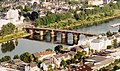
The Römerbrücke connects the west of Trier with the city center as one of three bridges.

The Marian column towers over the Trier-West district.

Villa Kockelsberg , entrance side

View from the Kockelsberg to the Petrisberg

Church of St. Markus on the Markusberg from the west

Church of St. Markus on the Markusberg from the south
Entrance to a protective bunker above Bitburger Strasse


culture and education
- European Art Academy : meeting place for international artists, in the listed buildings of the former slaughterhouse, directly on the Moselle.
- University of Trier : Campus Schneidershof as part of the University of Trier, on the edge of the Weißhauswald.
- Catholic Academy Robert-Schuman-Haus : meeting and educational center of the diocese of Trier , above Pallien.
- Civil service school Trier in the Villa Reverchon above the banks of the Moselle.
traffic

The main traffic axis is the federal highway 51 , which runs from the Moselle heights over Bitburger Strasse along the banks of the Moselle over Kölner, Aachener and Luxemburger Strasse . The federal road 53 reaches the district from the north on Bonner Strasse . Other main roads are Eurener Strasse and Hornstrasse, which run through the center of Trier-West.
population
Trier-West / Pallien has long been considered a social hotspot due to the large number of social housing that has been created from former barracks and a correspondingly high proportion of social welfare recipients .
Personalities
- Andreas Hoevel , (born February 24, 1900, † August 28, 1942 in Frankfurt-Preungesheim ), German resistance fighter against National Socialism
literature
- Thomas Simon : Brief message about the pension and educational institution set up by the grammar school teacher Th. Simon in Trier in the de Baring's house near St. Paulin for prospective pupils of local and foreign parents attending the grammar school, along with a few waves about the Striving and action of the institution . Hetzrodt, Trier 1824.
Web links
- Pallia with betting village house and white house from the panorama of Trier and its surroundings (around 1840) via dilibri
- Game in the Pallien Valley from Panorama of Trier and its surroundings (around 1840) via dilibri
- Trier-West / Pallien: Information on the "social city area" and the entire district
Individual evidence
- ↑ Bishop has desecrated Queen Mary in Trier-Pallien - building is in acute danger of collapsing. volksfreund.de, accessed on January 26, 2017 .
- ↑ St. Simeon is to be used as a storage site.
- ^ City of Trier: main statute. (PDF) § 2 to June 6, 2017, accessed on October 22, 2019 .
- ^ City of Trier - mayor / local advisory board. Retrieved July 17, 2019 .
- ^ The Regional Returning Officer Rhineland-Palatinate: direct elections 2019. Trier, independent city, see eighth line of results. Retrieved October 22, 2019 .
- ^ Morgen et al .: Trier restaurants yesterday and today. Volume V, Trier 2009, pp. 12/13.

Biewer | Ehrang / Quint | Your | Feyen / Weismark | Filsch | Holy Cross | Irsch | Kernscheid | Kürenz | Mariahof | Center / garden field | North | Olewig | Pfalzel | Ruwer / Eitelsbach | South | Tarforest | West / Pallien | Zewen