Roaster head
| Roaster head | ||
|---|---|---|
|
Rösterkopf near Reinsfeld |
||
| height | 708.1 m above sea level NHN | |
| location | Rhineland-Palatinate , Germany | |
| Mountains | Osburger Hochwald , Hunsrück | |
| Dominance | 12.4 km → Diebskopf near Damflos | |
| Coordinates | 49 ° 40 ′ 31 " N , 6 ° 50 ′ 6" E | |
|
|
||
| particularities | Telecommunications tower | |
The roaster head is 708.1 m above sea level. NHN the highest elevation of the Osburger Hochwald in the Hunsrück in Rhineland-Palatinate . The Ruwer rises at the foot of the roaster . The roaster head belongs to the municipality of Osburg .
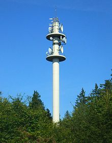
On top of the roaster there is a 58 m high telecommunications tower on which a Vodafone mobile phone station is located. E-Plus also operates a radio relay node there.
Rösterkopf circular hiking trail
If you want to hike on the Rösterkopf, you should use the Rösterkopf circular hiking trail. The path leads into the heart of the high forest around the Rösterkopf and to the Ruwer spring called Ruwerspring . The entry point is the hiking car park at Kreisstraße 75 , which leads from Kell am See to Landesstraße 146 .
See also
- Hohe Wurzel (Hunsrück) near Beuren / Hochwald
Individual evidence
- ↑ a b Map service of the landscape information system of the Rhineland-Palatinate Nature Conservation Administration (LANIS map) ( notes )
- ↑ https://www.ich-geh-wandern.de/r%C3%B6sterkopf-rundwanderweg-osburger-hochwald Experience report from hiking


