Pomeranian Voivodeship
|
|||
| map | |||
|---|---|---|---|
| Coat of arms and logo | |||

|

|
||
| Basic data | |||
| Capital | Danzig | ||
| Voivode | Dariusz Drelich | ||
| Voivodeship Marshal | Mieczysław structure | ||
| ISO 3166-2 | PL-22 | ||
| License Plate | G | ||
| Residents | 2,264,000 (March 31, 2011) | ||
| Population density | 121 inhabitants per km² | ||
| Unemployment rate | 8.4% (December 2008) | ||
| geography | |||
| Area : | 18,310 km² | ||
| - of which country: | ? km² | ||
| - of which water: | ? km² | ||
| Expansion: | North-South: 74-138 km West-East: 111-177 km |
||
| The highest point: | 331 m | ||
| Deepest point: | below sea level | ||
| Landscape structure | |||
| Forests: | 35.8% | ||
| Waters: | ? % | ||
| Agriculture: | 44.3% | ||
| Other: | ? % | ||
| Administrative division | |||
| Independent cities : | 4th | ||
| Powiate : | 16 | ||
| - Gminas : | 123 | ||
The Pomeranian Voivodeship , Polish województwo pomorskie , Kashubian Pòmòrsczé wòjewództwò , with the capital Gdańsk (Danzig) is one of the 16 voivodships of the Republic of Poland . During the territorial reform in 1999, it emerged from the Gdansk Voivodeships and part of the Słupsk (Stolp) , Elbląg (Elbing) and Bydgoszcz (Bromberg) voivodeships and includes the east of the historical Pomeranian landscape with Pomeranian and the extreme east of the former Prussian province of Pomerania (more precisely: Hinterpommerns ), also areas east of the Vistula, which belong to the historical Prussian landscape; it is thus measured similarly to the former Prussian province of West Prussia . It extends in the northwest over the area of the Pomeranian Voivodeship of the Polish aristocratic republic and that of the Pomeranian Voivodeship of the Second Polish Republic, but extends less far to the south, which in turn takes up the name of the neighboring Kujawy-Pomeranian Voivodeship .
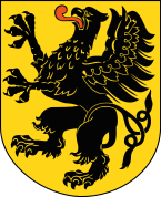
coat of arms
Description : A red-tongued black griffin in gold with a crossed tail.
administration
Since the regional and local elections on November 22, 2010, the 33 seats in the Sejmik have been distributed as follows: 19 - Platforma Obywatelska (PO), 7 - Prawo i Sprawiedliwość (PiS), 3 - Sojusz Lewicy Demokratycznej (SLD), 3 - Polskie Stronnictwo Ludowe (PSL), 1 - non-party.
The regional parliament is chaired by Jan Kleinschmidt (PO), his deputies are Dariusz Męczykowski (PO), Marek Biernacki (PO) and Piotr Zwara (PiS).
population
According to the 2011 census, about 2,280,000 people lived in the voivodeship. The largest ethnic groups were 2.22 million Poles (97.7%), 228,000 Kashubians (10%), 4,800 Germans and 4,200 Ukrainians (around 0.2% each), although belonging to several ethnic groups was not excluded.
Administrative division
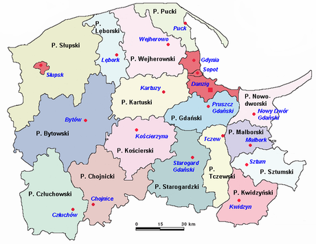
The Pomeranian Voivodeship is divided into 16 powiate and four independent cities. The Powiate Słupsk and Gdańsk are named after the independent cities, but the latter has its seat in Pruszcz Gdański (German Praust ).
One district cities
- Gdańsk (Kasch. Gduńsk ; Ger . Danzig ) 463,754; 262 km²
- Gdynia (Kasch. Gdiniô ; Ger . Gdynia ) 246,991; 135 km²
- Słupsk (Kasch. Stôłpsk / Słëpsk ; Ger . Stolp ) 91,935; 43 km²
- Sopot ( Kasch . Sopòt ; Eng . Sopot ) 36,849; 17 km²
Powiate
|
|
|
(Population and area on December 31, 2016)
| Counties | Greatest | Smallest |
|---|---|---|
| area-wise | Powiat Słupski | Powiat Malborski |
| in terms of population | Powiat Wejherowski | Powiat Nowodworski |
Tricity
Km² in an area of 1,332 and with a population of nearly one million people who closely spaced cities of Gdansk, Gdynia and Sopot form the Polish metropolitan Tri-City (Trójmiasto). The region around the Gdańsk Bay is one of the most densely populated regions in the country , along with the area around Warsaw and Krakow .
geography
Neighboring voivodeships
| Baltic Sea |
Kaliningrad Oblast Russia |
|
| West Pomeranian Voivodeship |

|
Warmian-Masurian Voivodeship |
| Greater Poland Voivodeship | Kuyavian-Pomeranian Voivodeship |
Cities of the Voivodeship
The voivodeship capital Gdansk is the sixth largest city in the country with around 460,000 inhabitants and by far the largest in the voivodeship. The nearby Gdynia has around 250,000 inhabitants, only slightly more than half as many.
| city | German name | Resident December 31, 2016 |
Area km² December 31, 2016 |
|---|---|---|---|
|
|
Danzig | 463.754 | 262 |
|
|
Gdynia | 246.991 | 135 |
|
|
Stumble | 91,935 | 43 |
|
|
Dirschau | 60,276 | 22nd |
|
|
Neustadt in West Prussia | 50,039 | 26th |
|
|
Prussian Stargard | 48.167 | 25th |
|
|
Rahmel | 48,095 | 30th |
|
|
Konitz | 40.004 | 21st |
|
|
Marienburg | 38,848 | 17th |
|
|
Marienwerder | 38,618 | 22nd |
|
|
Sopot | 36,849 | 17th |
|
|
Lauenburg | 35,378 | 18th |
|
|
Paw | 30.106 | 16 |
|
|
Rheda | 24,630 | 29 |
|
|
Berent | 23,847 | 16 |
|
|
Butow | 17,029 | 8th |
|
|
Stolpmünde | 15,812 | 10 |
|
|
Karthaus | 14,716 | 7th |
|
|
Schlochau | 13,946 | 13 |
|
|
Cute | 11.303 | 5 |
|
|
Rummelsburg | 10,632 | 6th |
|
|
Stool | 10,218 | 5 |
|
|
Großendorf | 10,020 | 39 |
|
|
Tiegenhof | 9,962 | 5 |
|
|
Czersk | 9,951 | 10 |
|
|
Giant castle | 8,735 | 5 |
|
|
Pelplin | 8,026 | 4th |
|
|
Schöneck | 7.136 | 10 |
|
|
Mewe | 6,840 | 7th |
|
|
Zuckau | 6,567 | 5 |
|
|
Hammerstein | 6,030 | 46 |
|
|
Christburg | 5,474 | 4th |
|
|
Bruß | 5,172 | 5 |
|
|
Prussian Friedland | 5,150 | 7th |
|
|
Neuteich | 4.185 | 5 |
|
|
Heisternest | 3,782 | 8th |
|
|
Leba | 3,734 | 15th |
|
|
Hammer mill | 3,689 | 6th |
|
|
Short | 3,545 | 4th |
|
|
Hela | 3,444 | 22nd |
|
|
Black water | 2,853 | 28 |
|
|
Kahlberg | 1,323 | 116 |
Rivers
economy
In comparison with the gross domestic product of the European Union in terms of purchasing power standards , the voivodeship achieved an index of 66 in 2015 (EU-28 = 100). The unemployment rate in 2005 was 18.9%. By December 2009 it had dropped to 12.0 percent. In 2017 the unemployment rate (according to Eurostat definition) was 4.3%.
With a value of 0.857, Pomerania ranks 6th among the 16 Voivodships in Poland in the Human Development Index .
partnership
The Pomorskie Voivodeship maintains a regional partnership with the Middle Franconia district in Bavaria .
tourism
Tourism plays an important role both in cities like Gdansk and on the coast in seaside resorts like Sopot and on Kashubian lakes.
Web links
- Marshal's Office of the Voivodeship (Polish, English)
- Voivodeship Office (Polish, English)
Footnotes
- ↑ Premier Beata Szydło powołała nowych wojewodów. Retrieved February 15, 2017 (Polish).
- ↑ Results of the 2011 census, Główny Urząd Statystyczny, Wyniki Narodowego Spisu Powszechnego Ludności i Mieszkań 2011. Warsaw, March 2012. Online ( Memento of January 16, 2013 in the Internet Archive ) (PDF)
- ↑ stat.gov.pl
- ↑ These voivodships with the same Polish name województwo pomorskie (1920–1950, 1938–1945 but województwo wielkopomorskie ) were referred to as the “Pomeranian Voivodeship” in distinction from the Duchy of Pomerania in the old empire (or later Province of Pomerania ).
- ↑ Circular 2011 of the Middle Franconia district, the partner region of Pomerania
- ↑ Statistics (PDF) by Główny Urząd Statystyczny
- ↑ population. Size and Structure by Territorial Division. As of December 31, 2016. Główny Urząd Statystyczny (GUS) (PDF files; 5.19 MB), accessed February 15, 2018 .
- ↑ Eurostat. Retrieved April 15, 2018 .
- ↑ PDF ( Memento of September 27, 2007 in the Internet Archive )
- ↑ Central Statistics Office of Poland (CIS), Bezrobotni oraz stopa bezrobocia wg województw, grudzień 2009 , February 3, 2010 ( Memento from April 2, 2015 in the Internet Archive )
- ↑ Unemployment rate, by NUTS 2 regions. Retrieved November 5, 2018 .
- ^ Sub-national HDI - Area Database - Global Data Lab. Retrieved August 12, 2018 .
Coordinates: 54 ° 12 ' N , 18 ° 1' E


