
Hel (city)
| Hel | |||
|---|---|---|---|

|
|
||
| Basic data | |||
| State : | Poland | ||
| Voivodeship : | Pomerania | ||
| Powiat : | puck | ||
| Area : | 21.27 km² | ||
| Geographic location : | 54 ° 36 ' N , 18 ° 48' E | ||
| Residents : | 3267 (Jun. 30, 2019) |
||
| Postal code : | 84-150 | ||
| Telephone code : | (+48) 58 | ||
| License plate : | GPU | ||
| Economy and Transport | |||
| Street : | Ext. 216 : Hel– Władysławowo - Reda | ||
| Rail route : | Reda-Hel | ||
| Next international airport : | Danzig | ||
| Gmina | |||
| Gminatype: | Borough | ||
| Residents: | 3267 (Jun. 30, 2019) |
||
| Community number ( GUS ): | 2211011 | ||
| Administration (as of 2015) | |||
| Mayor : | Klemens Kohnke | ||
| Address: | ul. Wiejska 50 84-150 Hel |
||
| Website : | www.hel-miasto.pl | ||


Hel [ ˈxɛl ] ( German Hela , Kashubian Hél ) is a port city on the Baltic Sea in the powiat Pucki (Putzig) of the Polish Pomeranian Voivodeship .
Geographical location
The city is located in the former West Prussia , at the tip of the Hel ( Hela , also Putziger Nehrung ) peninsula , which protrudes 36 kilometers from the mainland southeast into the Danzig Bay and forms the Zatoka Pucka (Putziger Wiek) . The Hel peninsula is not more than three kilometers and at its narrowest point only 400 meters wide and is protected from the waves of the Baltic Sea by a triple chain of dunes up to 25 meters high . The place Hel is located on an island-shaped widening at the tip of the peninsula and is about 25 kilometers northeast of Gdansk by sea .
history
The name Hel / Hela, the meaning of which is not clear, is of Scandinavian origin. The village is more than 700 years old. From the 13th to the 16th century, the two places Alt-Hela and Neu-Hela existed in close proximity to each other . Old Hela was about two kilometers northwest of today's city. Today's town goes back to the medieval village of Neu-Hela, which was probably founded as a merchant settlement by Lübeck merchants in the 13th century. In 1309 the city of Hela and Pomeranian came under the Treaty of Soldin to the Teutonic Order State of Prussia .
In 1351 wealthy citizens of the city founded the Katharinenbruderschaft , a merchants' guild whose aim was salvation and social welfare. The thirteen founding members were the Vogt and the following twelve citizens:
- Hans von Rudyn
- Jacob Czudener
- Hannß von der Wedeme
- Lutke Wolter
- Tydeke Hagemeister
- Hannß Obetyn
- Lodewig von dem Brincke
- Tydemann Striperog
- Peter of Koningisberk
- Claus Eyst
- Johannes Witte
- Kunke Molde
The Katharinengilde possibly existed in the 19th century.
With a document dated August 17, 1378, Winrich von Kniprode , at that time Grand Master of the Teutonic Order at the Marienburg , confirmed Heyle town charter , under Luebian law . In 1440 the magistrate signed the Federal Letter of the Prussian Federation . A council book drawn up in 1430 shows that the city had a hospital around 1470.
When Hela passed into the possession of the city of Danzig in 1453 , the free trade of the Helensians was stopped. In 1525 the magistrate joined the Reformation .
In the second half of the 16th century, Hela was affected by the First Northern War . In 1572 Alt-Hela probably burned down completely and was no longer rebuilt. The ruins of Alt-Hela were two kilometers northwest of the village, but can no longer be found today. In March 1577, Hela was attacked by the Polish colonel Ernst von Weiher and forced to pay homage to the Polish king Stephan . In the 17th century, too, Hela faced various difficulties. So in September 1626 the Swedish admiral Carl Carlsson Gyllenhielm appeared with a navy in front of Hela and asked the magistrate to take the oath of subjects for Gustav Adolf .
In the Third Partition of Poland , Hela and the city of Danzig came to the Kingdom of Prussia in 1793 and became its smallest municipality.
In 1872 the village lost its town charter. The building in which the Fisheries Museum is located today is the former St. Peter and Paul Church, a medieval church built in the brick Gothic style . In the last quarter of the 19th century, the Gdansk company Weichsel AG bought building sites on the southern tip of the peninsula and opened a spa in 1899 . At the turn of the 20th century, Hela had a Protestant church, a forest ranger's office, a seaside resort and a rescue station for the shipwrecked, and a new fishing port was built , a project by the chief construction director of the Prussian hydraulic engineering administration in Berlin, Ernst Nathaniel Kummer (1847–1923). The port also had a dock for larger ships.
Until 1920 Hela belonged to the district of Putzig in the administrative district of Danzig in the province of West Prussia . Due to the provisions of the Versailles Treaty , the Hela peninsula was ceded to Poland as part of the Polish Corridor after the First World War .
In December 1937, 160 fishing families who had lived here for generations (a total of over 600 people), who spoke mostly German and were Protestant, were expelled from the corridor area with a 24-hour period. The legal basis for the expulsion was an ordinance of the Polish President Ignacy Mościcki of December 23, 1927, which was published on January 22, 1937, the so-called Border Zone Act .
Following the German invasion of Poland and the occupation of the country in 1939 Hela was illegal under international law incorporated into the German Reich, as part of the district Puck in the administrative district of Gdansk , Reichsgau Danzig-West Prussia . In 1940, the Helensians - also known locally as Helschen - returned to their homes, but some of them fled from the approaching Soviet army towards the end of the Second World War in the spring of 1945.
The place became known through the stream of refugees at the end of the Second World War. As an important port of call for transport ships, hard-fought to the end, the last remnants of the Wehrmacht surrendered here on May 14, 1945 (?) To the troops of the Red Army . Soon after the occupation by the Red Army, the village was handed over to the Polish administration. As far as German Helensians had not fled, they were expelled by the local Polish administrative authorities in the following period .
As a holiday resort, Hel has been flourishing again since 1990. In 2002 the place signed a city partnership with Hermeskeil in Germany.
Population development until 1945
| year | Residents | Remarks |
|---|---|---|
| 1818 | 364 | in 74 residential buildings |
| 1831 | 382 | |
| 1864 | 372 | |
| 1867 | 380 | all evangelicals |
| 1871 | 495 | 425 of them in the city and 70 in the manor district |
| 1900 | 462 | |
| 1905 | 604 | thereof 563 Germans (93%) and 38 Poles (6%) |
| 1910 | 603 | 484 of them in the rural community and 119 in the manor district |
| 1921 | 550 |
City arms
The large council seal, the impression of which is preserved on a document from 1414, shows Apostle Peter holding up the key to the gate of heaven in his right hand and a martyr's crown in his left . Today's city coat of arms emerged from a second council seal, the so-called secret seal, and shows the sky key and two six-pointed stars.
traffic
Despite its exposed location, the city is connected to the Polish railway network via the Reda – Hel railway line. There are hourly passenger train connections to Gdynia , with all other trains to and from Hel stopping in Gdynia. In the summer season there are also connections to other major Polish cities, including Warsaw , Łódź and Krakow .
Attractions
- Former St. Peter and Paul Church, now a fishing museum
- lighthouse
- Seal station of the University of Gdansk
- port
gallery

lighthouse

Fire control tower

Port of Hel
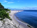
Beach

Seal station

Former St. Peter and Paul Church, now a fishing museum


,_Hel,_Polonia,_2013-05-23,_DD_04.jpg)

literature
- Hans Prutz : History of the Neustadt district in West Prussia . Danzig 1872, pp. 189-192 .
- August Eduard Preuss : Prussian country and folklore or description of Prussia. A manual for primary school teachers in the province of Prussia, as well as for all friends of the fatherland . Bornträger Brothers, p. 413, No. 29 .
- Friedrich Carl Gottlieb von Duisburg : Attempt of a historical-topographical description of the Königl. Prussia. Maritime and trading city of Gdansk . Second edition, G. Adolph Krause, Danzig 1816, pp. 426–454.
Web links
See also
Individual evidence
- ↑ a b population. Size and Structure by Territorial Division. As of June 30, 2019. Główny Urząd Statystyczny (GUS) (PDF files; 0.99 MiB), accessed December 24, 2019 .
- ↑ City website (BIP), Urząd Miasta Helu - Burmistrz Helu , accessed on April 6, 2015
- ↑ a b Friedrich August Vossberg : History of the Prussian coins and seals from the earliest times to the end of the rule of the Teutonic Order . Berlin 1843, p. 49.
- ↑ Seal and coat of arms of the city of Hela as of May 15, 2015.
- ^ Siegfried Rühle: The city of Hela in the Middle Ages. Journal of the West Prussian History Association. Issue 69. Kommissionsverlag Danziger Verlags-Gesellschaft, Danzig 1929, p. 116.
- ↑ Hela - A medieval merchant settlement? In: Halbinsel-Hela.de , as of September 20, 2015.
- ^ A b c Friedrich Carl Gottlieb von Duisburg : Attempt of a historical-topographical description of the Königl. Prussia. Maritime and trading city of Gdansk . Second edition, G. Adolph Krause, Danzig 1816, pp. 426–454.
- ↑ Johannes Voigt : Clear presentation of the legal constitution of Prussia during the time of the order . Marienwerder 1834, p. 64.
- ^ A b c d Hans Prutz: History of the Neustadt district in West Prussia . Danzig 1872, pp. 189-192 .
- ^ A b August Eduard Preuss : Prussian country and folklore or description of Prussia. A manual for primary school teachers in the province of Prussia, as well as for all friends of the fatherland . Bornträger Brothers, p. 413, No. 29 .
- ↑ a b c Baltic seaside resorts and cities on the Baltic coast. Meyer's travel books . 4th edition, Bibliographisches Institut, Berlin / Vienna 1910, p. 180 f.
- ^ Seeger: Hela - Geschichtliches und Kulturgeschichtliches. In: Communications of the German Sea Fisheries Association , No. 4, Moeser. Berlin 1910.
- ^ A b Meyers Konversations-Lexikon . 6th edition, Volume 9, Leipzig / Vienna 1908, p. 131.
- ^ Hugo Rasmus: Pommerellen West Prussia 1919-1939 . FA Herbig. Munich, Berlin 1989.
- ^ Johann Daniel Friedrich Rumpf and Heinrich Friedrich Rumpf: Complete topographical dictionary of the Prussian state . Volume 1, Berlin 1820, p. 481.
- ^ Prussian Ministry of Finance: Results of the property and building tax assessment in the administrative district of Danzig (7th district Neustadt) . Berlin 1867, pp. 10-11, no. 61.
- ^ Gustav Neumann: Geography of the Prussian State . 2nd edition, Volume 2, Berlin 1874, p. 44, point 6.
- ^ Hans Prutz : History of the Neustadt district in West Prussia . Danzig 1872, pp. 218-219, no. 64.
- ^ Community encyclopedia for the province of West Prussia: based on the materials from the census of December 1, 1905 and other official sources (Berlin 1908), p. 101 f.
- ↑ http://www.gemeindeververzeichnis.de/gem1900///gem1900.htm?westpreussen/rb_danzig.htm
- ↑ The Big Brockhaus . 15th edition, Volume 8, Leipzig 1931, p. 357.