Reda
| Reda | ||
|---|---|---|

|
|
|
| Basic data | ||
| State : | Poland | |
| Voivodeship : | Pomerania | |
| Powiat : | Wejherowo | |
| Area : | 29.45 km² | |
| Geographic location : | 54 ° 37 ′ N , 18 ° 20 ′ E | |
| Residents : | 26,011 (Jun. 30, 2019) |
|
| Postal code : | 84-240 | |
| Telephone code : | (+48) 58 | |
| License plate : | GWE | |
| Economy and Transport | ||
| Street : | DK 6 ( E 28 ): Gdansk - Stettin | |
| Ext. 216 : Reda- Władysławowo - Hel | ||
| Rail route : | Stargard Szczeciński – Gdańsk railway line | |
| Reda – Hel railway line | ||
| Next international airport : | Danzig | |
| Gmina | ||
| Gminatype: | Borough | |
| Residents: | 26,011 (Jun. 30, 2019) |
|
| Community number ( GUS ): | 2215011 | |
| Administration (as of 2007) | ||
| Mayor : | Krzysztof Krzemiński | |
| Address: | ul. Pucka 9 84-240 Reda |
|
| Website : | www.reda.pl | |
Reda ( German Rheda ) is a town in the powiat Wejherowski (Neustadt in West Prussia) in the Polish Pomeranian Voivodeship .
Geographical location
The village is located in Kashubia in the former West Prussia , in the glacial valley of the Reda (Rheda) and Łeba (Leba) rivers formed by the Ice Age . The main road leads through the city to the Hel (Hela) peninsula .
history

A wooden church was built in the 12th century . The first written mention of a place in the area of today's Reda comes from the year 1245.
From 1308 to 1466 the Neustädter District belonged to the Teutonic Order State . Around 1340 a mill and a forge were built. In 1357 the place of the Teutonic Order received city rights according to Kulm law . In 1358 the name Granslaw , 1398 Granslow and Granissow , 1400 Redau and 1433 Rede is mentioned. The place has been called Reda since around 1500. In the 17th century the wooden church was burned down.
Already during the time of the Teutonic Order, the region around Neustadt had been administered from Danzig , which had joined the Prussian Confederation in 1440 and voluntarily joined the autonomous Prussian Royal Share under the auspices of the Polish crown in 1466 .
On March 8, 1635, King Władysław IV. Wasa confirmed to the mayor Simon Borsch , whose privileges had been destroyed in a fire during the war against Danzig, the possession of the mayor's office Rheda and all of the rights and duties associated with it from ancient times.
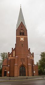
As part of the first partition of Poland in 1772, Rheda came to the Kingdom of Prussia . In 1785 Reda is referred to as a royal village with a Catholic church, a feudal mansion, an iron factory and a jug that has 20 fireplaces (households). A public school is inaugurated in 1888. In 1903 a church was built in the neo-Gothic style.
Until 1920, Rheda belonged to the Neustadt district in West Prussia in the Danzig administrative district of the West Prussian province of the German Empire .
After the First World War , the Neustadt district with Reda had to be ceded to Poland with effect from January 20, 1920 due to the provisions of the Versailles Treaty for the purpose of establishing the Polish Corridor . After the invasion of Poland in 1939, the district was annexed by the German Reich. It was assigned to the Reichsgau Danzig-West Prussia , to which Rheda belonged until 1945.
Towards the end of the Second World War , the Red Army occupied the village on March 12, 1945 , making it part of Poland again. The older spelling Reda was reintroduced for the place name . Had not fled far as German villagers, they were in the period that followed sold .
After the Second World War , the village first became part of the community Wejherowo ( Neustadt in West Prussia ). On January 1, 1955, a village council was set up in the place and a year later the place became an independent settlement again. The renewal of the town charter lasted until 1967, however. With an administrative reform in 1975 the place becomes part of the Gdansk Voivodeship , another reform causes the place to become part of the Pomeranian Voivodeship again in 1999 .
Population development
| year | 1829 | 1872 | 1924 | 1968 | 1982 | 1991 | 2000 | 2005 | 2011 |
|---|---|---|---|---|---|---|---|---|---|
| Residents | 74 | 763 | 1,000 | 5,400 | 6.091 | 14,000 | 17,663 | 18,360 | 22,030 |
Culture and sights
- Train station and surrounding buildings, built around 1875
- Warehouse and residential building in ul. Pucka from the 14th / 15th centuries century
Honorary citizen
- Tadeusz Gocłowski (1931-2016), Archbishop of Gdansk (2007)
literature
- Hans Prutz : History of the Neustadt district in West Prussia . Danzig 1872, e-copy .
Web links
- Reda's website (Polish)
Individual evidence
- ↑ a b population. Size and Structure by Territorial Division. As of June 30, 2019. Główny Urząd Statystyczny (GUS) (PDF files; 0.99 MiB), accessed December 24, 2019 .
- ^ Hans Prutz : History of the Neustadt district in West Prussia . Danzig 1872, p. 206 .
- ^ Johann Friedrich Goldbeck : Complete topography of the Kingdom of Prussia . Part I, Königsberg / Leipzig 1785, Complete Topography of the West Prussian Cammer Department , p. 183.
- ↑ for December 31, 2005, Główny Urząd Statystyczny : http://www.stat.gov.pl/dane_spol-gosp/ludnosc/stan_struk_teryt/2005/31_12/tablica8.xls


