
Gmina Luzino
| Gmina Luzino Gmina Lëzëno |
|||
|---|---|---|---|

|
|
||
| Basic data | |||
| State : | Poland | ||
| Voivodeship : | Pomerania | ||
| Powiat : | Wejherowo | ||
| Geographic location : | 54 ° 34 ' N , 18 ° 6' E | ||
| Residents : | see Gmina | ||
| Postal code : | 84-242 | ||
| Telephone code : | (+48) 58 | ||
| License plate : | GWE | ||
| Economy and Transport | |||
| Street : | Zelewo – Łebno | ||
| Rail route : | Stargard Szczeciński – Gdańsk | ||
| Next international airport : | Danzig | ||
| Gmina | |||
| Gminatype: | Rural community | ||
| Gmina structure: | 22 villages | ||
| 12 school offices | |||
| Surface: | 111.93 km² | ||
| Residents: | 16,391 (Jun. 30, 2019) |
||
| Population density : | 146 inhabitants / km² | ||
| Community number ( GUS ): | 2215072 | ||
| Administration (as of 2014) | |||
| Wójt : | Jarosław Piotr Wejer | ||
| Address: | ul. Ofiar Sztutthofu 11 84-242 Luzino |
||
| Website : | www.luzino.pl | ||

The Gmina Luzino or Gmina Lëzëno is a bilingual rural community in the powiat Wejherowski in the Polish Pomeranian Voivodeship . It has an area of almost 112 km², on which 16,391 people live (June 30, 2019). Its seat is the village of Luzino ( Kashubian Lëzëno ; German Lusin ).
geography
_location_map.png)
The rural community is located in Kashubia , about ten kilometers southwest of Wejherowo (Neustadt in West Prussia) , the seat of the Powiat . 49% of the area is arable land, 42% is forested. Luzino is located on the 31 kilometer long Bolszewka (also Luzińska struga; Bohlschau ).
history
From 1772 to 1920 the places of today's rural municipality Luzino belonged to the Prussian province of West Prussia . After the First World War , the area had to be ceded to Poland in 1920; it was part of the Polish Corridor . Some places in the rural community were on the border with the German Empire. After the invasion of Poland , place names were renamed numerous times in 1942 and 1943. In 1945 the area fell back to Poland.
Gmina Luzino was part of the Gdańsk Voivodeship from 1975 to 1998 . The 25th Missile Division (25 dr OP) was stationed in Dąbrówka from 1963 to 2011.
Parish partnership
Gmina Luzino maintains a partnership with the city of Stolzenau in Lower Saxony .
Community structure
Schulzenämter
The rural community of Luzino includes twelve villages, each with a Schulzenamt .
| Polish name | Kashubian name | German name (until 1920), (1942 / 1943ff) |
Pop. (2000) |
location | image |
|---|---|---|---|---|---|
| Barłomino | Barłomino |
Barlomin Bärwalde / Barmeln |
575 | (Location) |

|
| Dąbrówka | Dąbrówka | Damerkau (Dombrowka) | 341 | (Location) |

|
| Kębłowo | Kãbłowò | Kamlau | 2500 | (Location) | |
| Kochanowo | Kòchanowò | Platenrode | 361 | (Location) |

|
| Luzino | Lëzëno |
Lusin Freienau / Lintzau |
7560 | (Location) |

|
| Milwino | Milwino |
Mellwin Mellwen |
452 | (Location) |

|
| Robakowo | Robôkòwò |
Robbakau Rebbekau |
889 | (Location) | |
| Sychowo | Sychòwò | Schwichow | 358 | (Location) |
.jpg)
|
| Tępcz | Tãpcz | Tempsch , 1874: Hedille | 319 | (Location) |

|
| Wyszecino | Wëszecëno |
Wyschetzin Fünflinden |
481 | (Location) |

|
| Zelewo | Zélewò | Seelau | 371 | (Location) |

|
| Target now | Zélnowò |
Sellnow Silnau |
64 | (Location) |
Other localities
Bożejewo, Charwatynia (Castle Platen) , Dąbrówka Młyn (Damerkauermühle) , Kębłowska Tama, Kębłowski Młyn (Kamlauer mill) , Ludwikówko, Milwińska Huta, Nowe Kębłowo (New Kamlau) , Rzepecka, Wielki Las (Wielkilas) and Wyszecka Huta (Eichwalde) .
Attractions
- Listed, catholic church in Luzino (1733-1740, tower renewed)
- Former Evangelical Church in Luzino (1895), since 1977 community library
- Memorial for the death marches of the Stutthof concentration camp in Luzino
- Arboretum of the Strzebielino Forest District in Luzino
- Military Technical Museum (Muzeum Techniki Wojskowej GRYF) in Dąbrówka
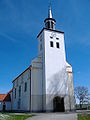
Catholic Church in Luzino

Municipal library in Luzino

Death march memorial in Luzino

Arboretum in Luzino


Web links
- Website of Gmina Luzino (Polish)
Individual evidence
- ↑ population. Size and Structure by Territorial Division. As of June 30, 2019. Główny Urząd Statystyczny (GUS) (PDF files; 0.99 MiB), accessed December 24, 2019 .
- ↑ The Historical Place Directory
