
Prabuty
| Prabuty | |||
|---|---|---|---|

|
|
||
| Basic data | |||
| State : | Poland | ||
| Voivodeship : | Pomerania | ||
| Powiat : | Kwidzyński | ||
| Gmina : | Prabuty | ||
| Area : | 7.29 km² | ||
| Geographic location : | 53 ° 45 ' N , 19 ° 12' E | ||
| Residents : | 8735 (Dec. 31, 2016) | ||
| Postal code : | 82-550 | ||
| Telephone code : | (+48) 55 | ||
| License plate : | GKW | ||
| Economy and Transport | |||
| Street : | Ext. 520 : Kamieniec-Prabuty | ||
| Ext. 521 : Kwidzyn - Susz - Iława | |||
| Ext. 522 : Górki – Sobiewola (- Kisielice ) | |||
| Rail route : | PKP - Route 9: Warsaw-Gdansk | ||
| Next international airport : | Danzig | ||

Prabuty [ praˈbutɨ ] ( German giant castle ) is a town with the seat of the town-and-country municipality of the same name in the powiat Kwidzyński of the Pomeranian Voivodeship in Poland .
location
The city is located in the former West Prussia in the Eylauer Seenplatte, about 20 km east-northeast of Kwidzyn (Marienwerder) and 10 km northwest of Susz (Rosenberg i. Westpr.) .
Surname
The German name of the city is derived from the Land Reisen (also Resia ), part of the Prussian Gau Pomesanien and has nothing to do with a legendary "giant". Nevertheless, a giant has been included in the town's coat of arms, which is still visible today on a medallion above the arch of the Marienwerder Gate (Brama Kwidzyńska) in the old town.
history
Riesenburg was first mentioned in 1250 and served from 1277 as the residence of Bishop Albert (1259–1286) of the diocese of Pomesania . The town next to the castle developed around 1300 and received its hand-held festivals from Bishop Rudolf (1322–1332). In 1323 as well as after the Battle of Tannenberg (1410) as well as in 1414 and 1422, Riesenburg was plundered and destroyed by Polish troops.
When the community joined the Prussian Federation in 1451 , Bishop Kasper unceremoniously deposed the mayor and city council, expelled them from the city and had their assets confiscated. Nevertheless, the Prussian Confederation was able to force membership in 1454. The Prussian Confederation lost the Battle of Konitz , whereupon Riesenburg converted back to the Teutonic Order , which in 1466 remained in the Second Peace of Thorn together with the secular part of the diocese of Pomesania. In 1523 the last bishop of Pomesania who had converted to the Reformation , Erhard von Queis , gave up his office in Riesenburg. The city was now in the Duchy of Prussia .
Half of the city burned down in 1628 and completely burned down in 1688. In 1710, 935 people died of the Great Plague . In the Seven Years' War (1756–1763), the citizens had to pay 18,408 Reichstaler in contributions to the Russian Empire .
The main sources of income for the town's citizens in the 19th century were handicrafts, brewing and agriculture. Riesenburg became its own administrative district in the Rosenberg district in West Prussia in the Marienwerder district of the West Prussia province and had a registry office and a district court .
Due to the provisions of the so-called Peace Treaty of Versailles , the population in the Marienwerder voting area , to which Riesenburg belonged, voted on July 11, 1920 on whether they would continue to belong to East Prussia (and thus to Germany) or join Poland. In Riesenburg, 3321 residents voted to remain with East Prussia; Poland had 50 votes. After the dissolution of the Marienwerder administrative district, it belonged to the West Prussia administrative district of the East Prussia province until 1939 , then to 1945 to the Reichsgau Danzig-West Prussia in the re-established Marienwerder administrative district (Danzig-Westpr.) . Towards the end of the Second World War , the Red Army destroyed 60% of the city in fighting with the army (Wehrmacht) . After the end of the war, Riesenburg was placed under the administration of the People's Republic of Poland . She introduced the place name Prabuty for Riesenburg , drove out the inhabitants and settled the place with Poles .
The community is now assigned to the Powiat Kwidzyński in the Pomeranian Voivodeship (1975-1998 Elbląg Voivodeship ).
Demographics
| year | Residents | Remarks |
|---|---|---|
| 1777 | 1,797 | |
| 1782 | 1,878 | 203 of them belonging to the garrison (staff and a squadron of a dragoons regiment) |
| 1831 | 2,722 | |
| 1864 | 3,397 | on December 3, including 3,147 Evangelicals and 62 Catholics |
| 1871 | 3,416 | including 3,150 Evangelicals and 70 Catholics |
| 1875 | 3,542 | |
| 1880 | 3,718 | |
| 1890 | 4,586 | including 643 Catholics and 123 Jews |
| 1900 | 5,032 | |
| 1905 | 4,826 | mostly Protestants |
| 1925 | 5,340 | mostly Protestants |
| 1933 | 6.116 | |
| 1939 | 8.093 |
| year | Residents | Remarks |
|---|---|---|
| 2012 | 8,488 | As of June 30, 2012 |
church

The townscape has been shaped by the parish church since the 14th century, which was a Protestant church from the Reformation until 1945. The second “small church” was built in the 15th century close to the castle, which later fell into disrepair and was demolished. Because church services were still held here in the Polish language in the 19th century, the Protestant church was called the “Polish Church” until 1945. Finally, the St. Andrew's Church was only built as a Catholic church in the 19th century.
Parishes
Evangelical
The Protestant parish of Riesenburg and Dakau, initially in the old Prussian parish of Riesenburg, later in the parish of Rosenberg , the parish too had been equipped with two clergymen since the Reformation, of which the “deacon” was the second or country pastor. A total of 45 localities belonged to the parish.
Today there is no longer any Protestant church in the city. Protestant church members are now looked after by the parish Elbląg ( German Elbing ). Kirchdorf is Mikołajki Pomorskie (Nikolaiken , 1939–45 Niklaskirchen) . It belongs to the diocese of Pomerania-Greater Poland of the Evangelical-Augsburg Church in Poland .
Catholic
An independent Catholic parish has only existed in Riesenburg since 1867. Before that, the city belonged to the parish of Schönwiese ( Polish Krasna Łąka ) and was part of the Diocese of Warmia . Today the Parafia Św. Wojciecha ( St. Adalbert ) in Prabuty. The city is the seat of the deanery named after it with six parishes that belong to the diocese of Elbing of the Catholic Church in Poland .
Ordensburg giant castle
The castle was founded in 1276/77. From 1277 it served as the residence of Bishop Albert (1259–1286) of the diocese of Pomesania . The castle was expanded from 1322 to 1340. Until 1523, Riesenburg and the castle remained the residence of the Bishop of Pomesania. After the bishop gave up his office in 1523, the castle gradually fell into disrepair. Destroyed by fire in 1787, it was later completely demolished. The foundations of the castle walls of the bishop's residence have been preserved.

Castle model in Prabuty

Dansker of the castle model in Prabuty

Foundations of the ruins of the bishop's palace

.JPG)

Attractions
- Parish church (built from 1330 to 1350 based on the model of the cathedral in Marienwerder, multiple alterations, in 1945 burned to the ground by Soviet troops, reconstruction in 1980 to 1983)
- Small ("Polish") church (built in 1412 with richly structured gable, burnt out in 1722, repaired again)
- Andreas Church (built 1878, tower 1903)
- Marienwerder Tor (Brama Kwidzyńska, from the 14th century, provided with a structure in 1850, restored to its medieval appearance after 1945) and parts of the city wall (from the same time)
- Rolandbrunnen (Fontanna Rolanda), designed by the Berlin architect Franz Schwechten in 1896 , stood at the Kaiser Wilhelm Memorial Church in Berlin-Charlottenburg from 1900 , where it had to give way to traffic planning and was acquired by the city of Riesenburg in 1928. In 2011 the statue of Roland removed in 1945 was reconstructed.
- Foundations of the bishop's castle of the Teutonic Order

City parish church (Protestant until 1945)

Small (“Polish”) church, built in 1412.

Andreas Church

Marienwerder Gate
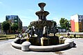
Roland fountain


.jpg)

.jpg)
Personalities
sons and daughters of the town
- Peter I of Oldenburg (1755–1829), Grand Duke of the State of Oldenburg
- Karl Alexander von Bardeleben (1770–1813), founder of the Prussian Landwehr
- August Wilhelm von Koch (1790–1861), Prussian general of the infantry
- Paul von Schoenaich (1866–1954), German major general, born in Klein Tromnau
- Adolf Treichel (1869–1926), German teacher and politician; President of the People's Day of the Free City of Gdansk
- Antonie Zerwer (1873–1956), pioneer of modern infant care
- Max Sitzler (1875–1952), curator of the University of Kiel
- Ernst Kuss (1888–1956), German chemist, smelter and social politician
- Charlotte Wolff (1897–1986), German doctor, sexologist
- Klaus Lazarowicz (1920–2013), German university professor and theater scholar
- Heino Falcke (* 1929), German Protestant theologian, provost
- Hartwig Reimann (* 1938), German local politician (SPD)
- Karl Friedrich Masuhr (* 1939), German neurologist, psychiatrist, book author and gallery owner
- Harald Dzubilla (* 1944), German journalist and children's radio play author
Personalities who have worked in the place
- Job von Dorbenck (around 1450–1521), Pomesan bishop
- Helius Eobanus Hessus (1488–1540), clerk and occasional poet for Bishop Job von Dorbenck
- Johann von Posilge (around 1340–1405), Prussian chronicler, official of the Bishop of Pomesania, lived in Riesenburg and probably died here
- Otto Friedrich von der Groeben (1657–1728), governor of Riesenburg and Marienwerder
traffic
In the city, the voivodship roads DW 520 ( Kamieniec –Prabuty), DW 521 ( Kwidzyn - Susz - Iława ( German Preußisch Eylau )) and DW 522 (Górki ( German cucumbers ), 1939–1945 Bergshausen –Sobiewola ( German Eigenwill ) meet ) and offer a convenient connection between the city and the region.
In addition, the Warsaw – Gdańsk line of the Polish State Railways (PKP) runs through the town. The Riesenburg – Marienwerder railway line, which is still used by freight, begins here. The Miswalde – Riesenburg railway line, which has been closed since 1945, and the Jabłonowo Pomorskie – Prabuty railway line, which has also been closed, end here.
Gmina Prabuty
The urban-and-rural commune of Prabuty covers an area of 197.12 km², which is almost 25% of the area of the powiat Kwidzyński , of which 7.29 km² falls within the city. The Gmina has 13,000 inhabitants, more than 65% of whom live in the urban area.
literature
- Daniel Heinrich Arnoldt : Brief messages from all preachers who have admitted to the Lutheran churches in East Prussia since the Reformation. Königsberg 1777, pp. 404-408.
- Johann Friedrich Goldbeck : Complete topography of the Kingdom of Prussia. Part II: Topography of West Prussia. Marienwerder 1789, pp. 6-8, No. 2).
- August Eduard Preuss : Prussian country and folklore. Königsberg 1835, p. 441, no.57 .
- Karl Josef Kaufmann: History of the city of Riesenburg. Giant Castle 1928.
- Karl Josef Kaufmann: History of the Rosenberg district. Volume 1, Rosenberg 1927.
- Friedwald Moeller : Old Prussian Evangelical Pastors' Book from the Reformation to the Expulsion in 1945. Hamburg 1968.
Web links
Individual evidence
- ^ A b c d e Johann Friedrich Goldbeck : Complete topography of the Kingdom of Prussia . Part II: Topography of West Prussia , Marienwerder 1789, p. 6, no. 2.
- ↑ Herbert Marzian , Csaba Kenez : self-determination for East Germany. Documentation on the 50th anniversary of the East and West Prussian referendum on July 11, 1920. Editor: Göttinger Arbeitskreis , 1970, p. 123
- ↑ a b Handbook of Historic Places , East and West Prussia , Kröner, Stuttgart 1981, ISBN 3-520-31701-X , p. 190.
- ^ August Eduard Preuss: Prussian country and folklore . Königsberg 1835, p. 441.
- ^ E. Jacobson: Topographical-statistical manual for the administrative district Marienwerder , Danzig 1868, pp. 120-121, item 156.
- ^ Gustav Neumann : Geography of the Prussian State . 2nd edition, Volume 2, Berlin 1874, pp. 49-50, item 3.
- ↑ a b c d e Michael Rademacher: German administrative history from the unification of the empire in 1871 to the reunification in 1990. Province of West Prussia, district of Rosenberg. (Online material for the dissertation, Osnabrück 2006).
- ↑ Meyers Großes Konversations-Lexikon , 6th edition, Volume 16, Leipzig 1909, pp. 925–926.
- ↑ Der Große Brockhaus , 15th edition, Volume 15, Leipzig 1933, p. 734.
- ↑ http://www.stat.gov.pl/cps/rde/xbcr/gus/l_ludnosc_stan_struktura_30062012.pdf
- ↑ 1817 to 1832 and 1886 to 1923 the parish belonged to the old Prussian church province West Prussia, in between to the church province of Prussia, from 1923 to 1940 to the church province of East Prussia and finally to the old Prussian church region of Danzig-West Prussia .
- ↑ See information from the Association for the History of Berlin eV: [1]
- ↑ See pictures of the ceremonial unveiling [2]