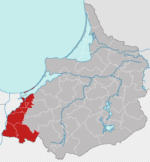
West Prussia administrative district
| Basic data | |
|---|---|
| Existing period: | 1920 - 1939 |
| Country : | Prussia |
| Province : | East Prussia |
| Administrative headquarters : | Marienwerder |
| Surface: | 2927.21 km² |
| Residents : | 301,808 (May 17, 1939) |
| Population density : | 103.1 inhabitants per km² |
| Structure: | 1 urban district 5 rural districts |
| Location of the administrative district | |

|
|
The administrative district of West Prussia was an administrative district of the Prussian province of East Prussia from 1920 to 1939 . Its territory is now divided between the Polish provinces of Pomerania and Warmia-Mazury . The administrative seat was Marienwerder .
Emergence
When the Versailles Treaty came into force , the Marienwerder administrative district of the Prussian province of West Prussia was dissolved on January 10, 1920. The districts of Graudenz and Thorn and the districts of Briesen, Culm, Konitz, Löbau, Schwetz, Strasburg i. Fell to the Second Polish Republic . Western pr. and Tuchel and the part of the Marienwerder district west of the Vistula. The western districts of Flatow and Schlochau were subordinated to the government office of the administrative district Grenzmark West Prussia-Posen in Schneidemühl on November 20, 1919 .
The districts of Elbing (city), Elbing (country), Marienburg, Stuhm, Rosenberg and Marienwerder (as far east of the Vistula), which remained east of Germany, were initially assigned to a district president based in Marienwerder (district of Marienwerder) and the senior president in Königsberg i. Subordinate to Pr.
On January 24, 1920 the districts of Marienburg, Marienwerder, Stuhm and Rosenberg were temporarily subordinated to the Inter-Allied Commission for Government and Referendum in Marienwerder. These circles belonged to the Marienwerder voting area , which was supposed to vote on its state affiliation. In the referendum on July 11, 1920, over 92 percent decided to remain with the German Reich and against cession to Poland. On August 16, 1920, the subordination to the Inter-Allied Commission for Government and Referendum ended . Until 1922 there were still minor border regulations with Poland and the Free City of Danzig .
On July 1, 1922, the Marienwerder administrative district was incorporated into the East Prussia province and renamed the West Prussian administrative district for reasons of tradition . The seat of the district president remained in Marienwerder.
Reorganization and final dissolution
At the beginning of the Second World War , German troops occupied Poland ( attack on Poland ) up to a demarcation line that had been agreed on September 28, 1939 in the so-called German-Soviet border and friendship treaty . This also included the areas of the former Prussian province of West Prussia , which fell to Poland in 1920 , from which the "Military District West Prussia" was formed in mid-September 1939.
On October 26, 1939, the former East Prussian administrative district of West Prussia was combined with the "Military District of West Prussia" annexed on the same day and, together with the Free City of Danzig, which was incorporated into the German Reich on September 1, 1939, formed the Reichsgau West Prussia. This was renamed on November 2, 1939 in Reichsgau Danzig-West Prussia . The new administrative district Marienwerder was formed together with the previously Polish districts of Briesen (West Pr.) , Graudenz , Leipe (West Pr.) , Neumark (West Pr.) , Rippin (West Pr.) And Strasburg (West Pr.) . The city and district of Elbing were incorporated into the new administrative district of Danzig.
In the spring of 1945 the former territory of the administrative district was occupied by the Red Army , placed under Polish administration and finally added to the People's Republic of Poland . Today the area is divided into the Polish Pomeranian and Warmian-Masurian Voivodeships .
Administrative division
City and rural districts
| Reg.Bez. until 1920 |
City / district | Residents | surface | Population density | Municipalities, cities / spots / municipalities |
|---|---|---|---|---|---|
| Danzig | Elbing district | 85,952 | 30.67 km² | 2802.5 inh / km² | 1/0/0 |
| Danzig | District of Elbing | 28,149 | 482.99 km² | 58.3 inh / km² | 1/0/70 |
| Danzig | Marienburg district | 39,073 | 225.66 km² | 173.1 inh / km² | 1/1/35 |
| Marienwerder | Marienwerder district | 44,813 | 525.70 km² | 85.2 inh / km² | 2/0/51 |
| Marienwerder | Rosenberg district | 63,368 | 1038.31 km² | 61.0 inh / km² | 5/0/79 |
| Marienwerder | District of Stuhm | 40,453 | 622.60 km² | 65.0 inh / km² | 2/0/65 |
| total | 301,808 | 2925.93 km² | 103.1 inh / km² | 12/1/300 |
District President
- 1920–1922: Theodor von Baudissin
- 1922–1923: Alfons Proske
- 1923–1925: Roland Brauweiler
- 1925–1936: Karl Budding
- 1936–1939: Otto von Keudell
Individual evidence
- ↑ Home Atlas for the Province of East Prussia. Weltbild publishing group, Augsburg 2007, ISBN 978-3-8289-0832-1 .
