Olsztyn administrative district

The district of Allenstein was from 1905 to 1945 an administrative district of the Prussian province of East Prussia . Today its territory belongs to the Polish Warmian-Masurian Voivodeship .
history
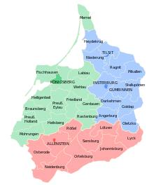
The Olsztyn administrative district was established in 1905 as the third East Prussian administrative district. The aim of this measure was, among other things, the cultural and economic promotion of Masuria . It was formed from parts of the Gumbinnen administrative district and the Königsberg administrative district. With Masuria, southern Warmia and the Oberland (Warmia-Masuria) , the administrative district covered an area of 11,711 km² in 1905. The seat of the district president was in Olsztyn .
After the First World War and the Versailles Peace Treaty , part of the Neidenburg district had to be ceded to Poland without a referendum : the strategically important Warsaw – Gdańsk railway was located in the Soldau area . After the referendum on July 11, 1920 (see Allenstein voting area ), the border towns of Groschlen, Klein Nappern and Klein Lobenstein in the Osterode district were also ceded. The area of the administrative district was reduced to 11,520 km² as a result of these territorial losses.
After the Second World War , the territory of the Olsztyn administrative district was placed under Polish administration. The German population was then largely expelled on the basis of the so-called Bierut decrees .
Development of the population
- 1925: 540,290, including 40,200 residents with Masurian and 13,700 with Polish as their mother tongue
| Olsztyn administrative district | |||||
|---|---|---|---|---|---|
| year | 1910 | 1925 | 1933 | 1939 | |
| Residents | 518,682 | 540.287 | 552,541 | 568.024 | |
Administrative structure
City and rural districts
| Reg.Bez. until 1905 |
City / district | Residents | surface | Population density | Municipalities, cities / spots / municipalities |
|---|---|---|---|---|---|
| Koenigsberg | Olsztyn district | 50,396 | 53.13 km² | 856.6 inh / km² | 1/0/0 |
| Koenigsberg | Olsztyn district | 57,150 | 1302.58 km² | 43.9 inh / km² | 1/0/130 |
| Gumbinnen | District of Johannisburg | 53,089 | 1684.02 km² | 31.5 inh / km² | 3/2/168 |
| Gumbinnen | Lötzen district | 50,012 | 897.38 km² | 55.7 inh / km² | 2/1/87 |
| Gumbinnen | District of Lyck | 56,417 | 1115.08 km² | 50.6 inh / km² | 1/4/154 |
| Koenigsberg | Neidenburg district | 39,730 | 1146.11 km² | 34.7 inh / km² | 1/2/110 |
| Koenigsberg | Ortelsburg district | 73,442 | 1702.84 km² | 43.1 inh / km² | 3/5/156 |
| Koenigsberg | District of Osterode | 81,513 | 1536.25 km² | 53.1 inh / km² | 4/1/168 |
| Koenigsberg | Rößel district | 51,832 | 850.84 km² | 60.9 inh / km² | 4/0/81 |
| Gumbinnen | Sensburg district | 54,443 | 1231.53 km² | 44.2 inh / km² | 2/2/122 |
| total | 568.024 | 11519.76 km² | 49.3 inh / km² | 22/17/1176 |
District President
- 1905–1907: Wilhelm von Hegel
- 1907–1908: Friedrich Karl Gramsch
- 1908–1917: Hans von Hellmann
- 1918–1924: Matthias von Oppen
- 1924–1932: Max von Ruperti
- 1933–1945: Karl Schmidt
language
According to the 1910 census, the linguistic situation in the individual districts of the Olsztyn administrative district was as follows:
| 1910 census | population | German | Masurian | Polish | Bilingual | ||||
|---|---|---|---|---|---|---|---|---|---|
| Olsztyn administrative district | 543,469 | 274,320 | 50.48% | 175.016 | 32.20% | 73.154 | 13.46% | 19,532 | 3.59% |
| Olsztyn city | 33,077 | 29,344 | 88.71% | 99 | 0.30% | 2,249 | 6.80% | 1,325 | 4.01% |
| Olsztyn Land | 57,919 | 22,825 | 39.41% | 520 | 0.90% | 32,766 | 56.57% | 1,782 | 3.08% |
| Johannisburg | 51,399 | 16,379 | 31.87% | 29,141 | 56.70% | 4,203 | 8.18% | 1,620 | 3.15% |
| Soldering | 41.209 | 26,352 | 63.95% | 11,412 | 27.69% | 1,595 | 3.87% | 1,802 | 4.37% |
| Elk | 55,579 | 27,138 | 48.83% | 19,407 | 34.92% | 6,348 | 11.42% | 2,590 | 4.66% |
| Neidenburg | 59,416 | 20,871 | 35.13% | 25,150 | 42.33% | 10,462 | 17.61% | 2,645 | 4.45% |
| Ortelsburg | 69,935 | 20,218 | 28.91% | 43,513 | 62.22% | 3,390 | 4.85% | 2,463 | 3.52% |
| Osterode | 74,666 | 43,508 | 58.27% | 26,695 | 35.75% | 2.130 | 2.85% | 2,279 | 3.05% |
| Rössel | 50,472 | 43,189 | 85.57% | 48 | 0.10% | 6,512 | 12.90% | 1.42% | 1.42% |
| Sensburg | 50.097 | 24,496 | 48.90% | 19,031 | 37.99% | 3,499 | 6.98% | 2,310 | 4.61% |
literature
- Klaus von der Groeben : The country of East Prussia. Self-preservation, self-development, self-administration 1750 to 1945. (= sources on administrative history. 7). Lorenz von Stein Institute, Kiel 1993, DNB 930875869 .
- Rüdiger Döhler : Corps students in the administration of East Prussia. In: then and now. Volume 54, 2009, pp. 240-246.
Web links
Individual evidence
- ↑ The Big Brockhaus. 15th edition. 1st volume, Leipzig 1928, p. 30.
- ^ Statistical yearbooks for the German Empire. In: DigiZeitschriften. Retrieved December 7, 2019 .
- ↑ Home Atlas for the Province of East Prussia. Weltbild publishing group, Augsburg 2007, ISBN 978-3-8289-0832-1 .
- ↑ s. Allenstein voting area
- ↑ Jakob Spett: Nationality map of the eastern provinces of the German Empire based on the results of the official census of 1910 designed by Ing.Jakob Spett . Justus Perthes, January 1, 1910 ( bibliotekacyfrowa.pl [accessed March 14, 2017]).

