Gumbinnen district
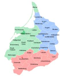
The Prussian government district Gumbinnen was in northeast Prussia . It existed from 1808 to 1945, initially under the name of Litthauen zu Gumbinnen district . From 1824 to 1878 it formed the easternmost part of the Province of Prussia , then the Province of East Prussia .
Administrative history
The great plague from 1709 to 1711 hit Gumbinnen particularly hard. In July 1724 a deputation (branch) of the Königsberg War Chamber was set up in Gumbinnen. She was responsible for the main offices of Insterburg, Memel, Ragnit and Tilsit. On August 19, 1736, the deputation was transformed into an independent "Lutheran War and Domain Chamber" . The administrative district of Gumbinnen was created by the renaming of the War and Domain Chamber by the Publicandum on December 16, 1808.
At the request of the citizens of the city of Memel , the district of Memel was assigned to the government in Königsberg on September 1, 1816 . To compensate, numerous inland parishes were assigned to the Gumbinner district . The district division was then revised, since the districts, because they were too large, did not meet the requirement that it should be possible to travel from the most distant part of the district to the district town - and back - within one day.
As a rule, the greatest distance should not exceed three miles , i.e. just under 22 km. Since a district should have between 20,000 and 36,000 inhabitants at the same time, the layout of the circles in the sparsely populated " Lithuanian " districts was quite laborious, especially since old affiliations had to be taken into account.
In 1885 the entire district covered an area of 15,870 km². The population was
- 1880: 778,422, including 756,448 Protestants, 12,064 Catholics, 4,088 other Christians and 5,791 Jews
- 1885: 788.074
- 1900: 792.240
- 1910: 804.871 (updated including the four districts submitted in 1905)
In 1896 the city of Tilsit and in 1901 the city of Insterburg became independent, so they formed their own city districts.
With effect from November 1, 1905, the four southern districts ( Johannisburg , Lötzen , Lyck and Sensburg ) were separated from the Gumbinnen district and combined with the southern part of the Königsberg district to form the new Allenstein district.
After the First World War, the German Reich had to cede the Memel area . The districts of Memel and Heydekrug were thus lost, the district of Tilsit for the most part. Its communities south of the Memel were merged with the district of Ragnit to form the district of Tilsit-Ragnit in 1922 . The left-Memel communities of the Heydekrug district were assigned to the Niederung district in 1922.
In 1938, 1146 names of the 1765 parishes in the Gumbinnen district were "Germanized".
When Lithuania had to return the Memel area to the German Reich in 1939, the administrative district of Gumbinnen was given the supervision of all Memel Land districts (Memel and Heydekrug) and the enlarged Tilsit-Ragnit district.
In 1939, departmental directors headed the General Department (Government Vice President Eichhart), the Department for Churches and Schools (Theisen) and the Agriculture Department (Karbe).
The last changes in the territorial existence of the district resulted from the annexation of Polish territory around Suwałki and Augustow , which was assigned to the administrative district of Gumbinnen as the district of Suwalken in November 1939 and renamed the district of Sudauen in May 1941 . In 1943, part of this district was given to the neighboring and now also annexed Bialystok district to the southeast .
The German administration ended in the winter of 1944/45 with the invasion of Soviet troops and the expulsion of the Germans. Most of the Gumbinnen administrative district today belongs to the Kaliningrad Oblast of the Russian Federation , while the powiate of the Warmian-Masurian Voivodeship are located in the south .
Administrative division
City and rural districts
Status from before the return of the Memelland:
| City / district | Residents | surface | Population density | Municipalities, cities / spots / municipalities |
Remarks |
|---|---|---|---|---|---|
| Insterburg district | 48,711 | 44.11 km² | 1104.3 inh / km² | 1/0/0 | |
| Tisit urban district | 58,468 | 59.02 km² | 990.6 inh / km² | 1/0/0 | |
| Angerapp district | 31,549 | 759.49 km² | 41.5 inh / km² | 1/1/163 | until 1938: Darkehmen district |
| Angerburg district | 42,744 | 929.28 km² | 46.0 inh / km² | 1/1/72 | |
| District of Ebenrode | 41,265 | 703.90 km² | 58.6 inh / km² | 2/1/170 | until 1938: Stallupönen district |
| Elch lowlands district | 55,376 | 1003.12 km² | 55.2 inh / km² | 0/5/221 | |
| Goldap district | 45,825 | 993.34 km² | 46.1 inh / km² | 1/2/171 | |
| Gumbinnen district | 55.272 | 730.61 km² | 75.7 inh / km² | 1/0/158 | |
| Insterburg district | 43,224 | 1160.83 km² | 37.2 inh / km² | 0/0/177 | |
| District of Schloßberg | 42,656 | 1059.40 km² | 40.3 inh / km² | 2/2/241 | until 1938: Pillkallen district |
| Tilsit-Ragnit district | 56,117 | 1100.45 km² | 51.0 inh / km² | 1/4/264 | |
| District of Treuburg | 37,998 | 855.81 km² | 44.4 inh / km² | 1/4/96 | until 1938: Oletzko district |
| total | 559.205 | 9,399.36 km² | 59.5 inh / km² | 12/20/1733 |
District President
District presidents were:
|
|
literature
- Rolf Engels: The Prussian administration of the Gumbinnen Chamber and Government 1724–1870 (= studies on the history of Prussia. 20). Grote, Cologne 1974, ISBN 3-7745-6326-8 .
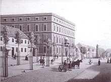
- Herbert Kirrinnis : The government building at Gumbinnen. In: Prussia. Volume 2, 1964, p. 23.
- Klaus von der Groeben : The country of East Prussia. Self-preservation, self-development, self-administration 1750 to 1945. (= sources on administrative history. 7). Kiel 1993, DNB 930875869 .
- Rüdiger Döhler : Corps students in the administration of East Prussia. In: then and now . Volume 54, 2009, pp. 240-246.
Web links
- Literature by and about Gumbinnen administrative district in the catalog of the German National Library
- Administrative history Gumbinnen Administrative history and the regional presidents on the website territorial.de (Rolf Jehke), as of August 1, 2013.
Individual evidence
- ↑ a b Gumbinnen administrative district (territorial.de)
- ^ Victor Klemperer: LTI: Notebook of a Philologist. 7th edition. Verlag Philipp Reclam jun., 1982, DNB 830150226 , pp. 87/88.
- ↑ Victor Klemperer: I want to give testimony to the last. Diaries. DNB 981640168 , notes from November 17, 1942.
- ^ Prussian State Handbook. published by the Prussian State Ministry for 1939, 141st vol.
- ↑ Home Atlas for the Province of East Prussia. Weltbild publishing group, Augsburg 2007, ISBN 978-3-8289-0832-1 .
- ^ Corps Saxo-Borussia Heidelberg


