
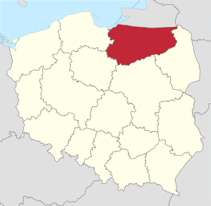
Warmian-Masurian Voivodeship
|
|||
|---|---|---|---|
| map | |||
  |
|||
| Coat of arms and logo | |||

|
|
||
| Basic data | |||
| Capital : | Olsztyn | ||
| Voivode : | Artur Chojecki | ||
| Voivodeship Marshal : | Gustaw Marek Brzezin | ||
| Biggest town: | Olsztyn | ||
| ISO 3166-2 : |
PL-28
|
||
| Residents : | 1,429,000 (December 31, 2018) | ||
| Population density : | 59 inhabitants per km² | ||
| geography | |||
| Area : | 24 173 km² | ||
| biggest expansion: | North-South: 142 km West-East: 220 km |
||
| The highest point: | 312 m | ||
| Deepest point: | 1.8 m below sea level | ||
| Landscape structure | |||
| Forests: | 29.9% | ||
| Waters: | 6% | ||
| Agriculture: | 42.8% | ||
| Administrative division | |||
| Sub-regions: | Elbląg , Olsztyn , Ełk | ||
| Independent cities : | 2 | ||
| Counties : | 19th | ||
| Municipalities : | 116 | ||
| - Municipalities: | 16 | ||
| - urban / rural district: | 34 | ||
| - rural communities: | 66 | ||
The Warmian-Masurian Voivodeship ( Polish Województwo warmińsko-mazurskie ) with the capital Olsztyn (Allenstein) is one of the 16 voivodships of the Republic of Poland . It was formed in the course of the Polish territorial reform of 1999 from parts of the Olsztyn , Suwałki and Elbląg voivodeships and comprises the north-eastern part of Poland, historically the southern part of the former East Prussia . It borders from northwest to northeast on the voivodeships of Pomerania , Kuyavian-Pomerania , Mazovia and Podlaskie , in a four-country corner on Lithuania and in the north on the Russian exclave of Kaliningrad Oblast and on a short stretch of coast of the Fresh Lagoon .
geography
The Warmia - Masurian region , together with the Russian Kaliningrad Oblast, essentially corresponds to the former East Prussia. Large parts of the sparsely populated landscape are shaped by the Masurian Lake District , which is important for tourism , among other things . The former diocese of Warmia in the west is the Catholic heartland of the region. The south-western part of the voivodeship is called the Oberland .
Large parts of the soil belong to soil classes 4 and 5. As raw materials, sand and gravel are interesting for the building industry and loam, peat and clay for the ceramic industry . About 30 percent of the area is covered by forests.
climate
Warmian-Masurian lies in the transition zone from continental to oceanic climate . The annual average temperature is between 7 and 7.5 ° C . The mean temperature in January is −2.5 to −3.5 ° C. The average annual rainfall is 600 mm, with July and August having the most rainfall and February and May the least.
population
The population that has lived there since 1945 after the expulsion of the Germans consists largely of the descendants of the Poles from central and eastern Poland who settled in the region . There is also a large group of Ukrainians living in the voivodeship. A small part of the population belongs to the German or Masurian minority.
coat of arms
Description : In red, a gold-edged, gold-crowned and gold-armored silver eagle with a golden clover stem over a red-bleeding silver Agnus Dei with a golden chalice under the belly next to a gold-edged, gold-reinforced black eagle with a golden clover stem and a gold-crowned golden majusc -S. With black thread the division and the lower split is visible.
Symbolism: The voivodeship's coat of arms is divided into three parts. The upper half contains a white, gold-crowned eagle, symbolizing Poland . In the lower field in front is a white, heraldic silver lamb with a golden halo, bleeding, a golden chalice and a golden rod with a cross and a flag. This field shows the coat of arms of the Principality of Warmia , which enjoyed extensive independence between 1466 and 1772 under Polish sovereignty. The back third below contains a black eagle with a gold crown on its neck and the letter S on its chest. The eagle corresponds to the Prussian eagle , but the capital S stands for Sigismund I, the old man who was King of Poland from 1506 and suzerain of the Duchy of Prussia from 1525 . With the exception of the field color, this field corresponds to the first version of the coat of arms of the Duchy of Prussia . Thus, references to the political past of the region as the duchy of Warmia, Prussian territory and the current Polish affiliation are included. The references to the past emphasize the historical and political dependencies on Poland. The coat of arms designed by Paul Dudzinski became official by a resolution of the regional assembly on August 6, 2002.
Administrative division
The Warmian-Masurian Voivodeship is divided into 19 powiats , with Olsztyn and Elbląg remaining independent. Although they also form a district under their own name, they do not belong to it themselves.
One district cities
Counties
|
In brackets the German name and the residents on June 30, 2012
Biggest cities
The provincial capital Olsztyn is the largest city in the Warmian-Masurian Voivodeship with around 175,000 inhabitants. The only other major city is Elbląg.

| city | German name | Residents June 30, 2012 |
|---|---|---|
|
|
Allenstein | 175,482 |
|
|
Elblag | 123.977 |
|
|
Elk | 59,370 |
|
|
Osterode | 34,020 |
|
|
German Eylau | 33,331 |
|
|
Soldering | 30.096 |
|
|
Rastenburg | 28,286 |
|
|
Ortelsburg | 25,030 |
|
|
Bartenstein | 24,771 |
|
|
Sensburg | 22,219 |
|
|
Soldau | 21,592 |
economy
Purchasing power
When compared with the gross domestic product of the EU , expressed in purchasing power standards , the voivodeship achieved an index of 49 in 2015 (entire EU = 100).
unemployment
The unemployment rate in 2005 was 20.4%. In December 2009 it was almost unchanged at 20.2 percent, which corresponds to 109,200 people. In the following years the rate halved and in December 2018 it was 11.4 percent, which corresponds to 53,141 people. This means that the Warmia-Masurian Voivodeship is still the voivodeship with the highest unemployment rate, with a rate that is more than twice the national average.
Human development
With a value of 0.816, Ermsland-Masuria ranks last among the 16 Voivodships in Poland in the Human Development Index .
Web links
- Warmińsko-Mazurski Urząd Wojewódzki w Olsztynie - website of the regional administration in Olsztyn (pol., Eng., Eng., Rus.)
- Warmia i Mazury - regional portal (pol.)
Individual evidence
- ↑ Urząd Statystyczny w Olsztynie. Retrieved December 8, 2019 .
- ↑ January Baldowski: Warmia and Mazury. ISBN 3-87466-173-3 , pp. 16-17.
- ↑ January Baldowski: Warmia and Mazury , ISBN 3-87466-173-3 , page 15
- ↑ Uchwała no XXXIX / 561/02 Sejmiku Województwa Warmińsko-Mazurskiego z dnia 6 sierpnia 2002 r. w sprawie ustanowienia herbu, flagi, pieczęci oraz odznaki radnego Województwa Warmińsko-Mazurskiego ( Memento of December 12, 2011 in the Internet Archive ) (Dz. Urz. woj. warmińsko-mazurskiego z 2002 r. No. 121, poz. 1752; PDF; 356 kB)
- ↑ a b Główny Urząd Statystyczny (Central Statistical Office): Ludność - Stan i Struktura w przekroju terytorialnym (Population in Poland - Size and structure by territorial division), as of June 30, 2012 ( Memento of October 12, 2013 in the Internet Archive ) (PDF; 626 kB; Polish, English) ()
- ↑ Eurostat. (PDF) Retrieved April 15, 2018 .
- ↑ http://www.eds-destatis.de/en/downloads/sif/dn_06_01.pdf ( Memento from September 27, 2007 in the Internet Archive )
- ↑ Central Statistics Office of Poland (CIS), Bezrobotni oraz stopa bezrobocia wg województw, grudzień 2009 , February 3, 2010 ( Memento of April 2, 2015 in the Internet Archive )
- ↑ Statistics Office Olsztyn, Infografika - Bezrobocie w województwie warmińsko-mazurskim - stan na koniec IV kwartału 2018 r. , Dec. 31, 2018
- ^ Sub-national HDI - Area Database - Global Data Lab. Retrieved August 12, 2018 .

Warmia-Masuria | Greater Poland | Holy Cross | Subcarpathian | Lesser Poland | Kuyavia-Pomerania | Lebus | Łódź | Lublin | Mazovia | Lower Silesia | Opole | Podlaskie | Pomerania | Silesia | West Pomerania
Independent cities: Elbląg (Elbing) | Olsztyn (Allenstein)
Counties: Bartoszyce (Bartenstein) | Braniewo (Braunsberg) | Działdowo (Soldau) | Elbląg (Elblag) | Ełk (Elk) | Giżycko (Lötzen) | Gołdap (Goldap) | Iława (German Eylau) | Kętrzyn (Rastenburg) | Lidzbark (Heilsberg) | Mrągowo (Sensburg) | Nidzica (Neidenburg) | Nowe Miasto (Neumark) | Olecko (Treuburg) | Olsztyn (Alone Stone) | Ostróda (Osterode in Ostpr.) | Pisz (Johannisburg) | Szczytno (Ortelsburg) | Węgorzewo (Angerburg)
Coordinates: 53 ° 51 ' N , 20 ° 50' E