Bonerath
| coat of arms | Germany map | |
|---|---|---|

|
Coordinates: 49 ° 41 ′ N , 6 ° 45 ′ E |
|
| Basic data | ||
| State : | Rhineland-Palatinate | |
| County : | Trier-Saarburg | |
| Association municipality : | Ruwer | |
| Height : | 424 m above sea level NHN | |
| Area : | 4.25 km 2 | |
| Residents: | 233 (Dec. 31, 2019) | |
| Population density : | 55 inhabitants per km 2 | |
| Postal code : | 54316 | |
| Area code : | 06588 | |
| License plate : | TR, SAB | |
| Community key : | 07 2 35 010 | |
| LOCODE : | DE 47B | |
| Association administration address: | Untere Kirchstrasse 1 54320 Waldrach |
|
| Website : | ||
| Mayoress : | Gabriele Terres | |
| Location of the local community Bonerath in the district of Trier-Saarburg | ||
Bonerath ( Moselle Franconian : Bönert ) is a municipality in the district of Trier-Saarburg in western Rhineland-Palatinate . It belongs to the Verbandsgemeinde Ruwer , which has its administrative headquarters in Waldrach .
geography
The place offers a panoramic view of the middle and upper Ruwertal with its mountain ranges as well as the Riveristal with the Riveristalsperre , the Misselbach valley and the heights of the Osburger Hochwald .
The Langeichhof residential area also belongs to Bonerath .
history
Around 55 BC The Romans under Caesar conquered the land of the Treveri . In the third or fourth century a Roman villa rustica was built on the "Casselheck" . Between 900 and 1200 the Franks cleared the Hunsrück. Around 1200 Bonerath was probably under the archbishop's forestry office on the high forest. In 1239 there was a report of a man named "Bonclath" who might be the founder or the namesake of the village.
On February 27, 1330 Archbishop Balduin von Trier recorded that Johann d'Orreo, citizen and aldermen of Trier, received 1/2 Manse of farmland and taxes from "Bonrade" (other sources say "Bonrode"). The widow of Johann d'Orreo married Friedrich von Schmidtburg in 1355 , who thus received the hereditary gift rights and the taxes of the place from this office, according to the electoral description of the office, this was connected to the basic jurisdiction over the whole of Bonerath.
In 1466 a place called "Urenberg" was mentioned, which was in the Schöndorf parish and has since disappeared. According to the Trier fire book of 1563 , six families (fireplaces) were resident in "Bonrath". Six years later the place was called "Bonroit" (but also "Bonroidt or Bonrath") in old documents. In connection with a visitation, Bonerath was named as the daughter church of Schöndorf. From the chapel of St. Arnold in Bonerath was reported to have been in disrepair for a long time.
According to a visitation report from 1630, there are eight families in "Bonrodt". The gentlemen of Meysenburg-Brandenburg-Clervaux, called the "Rodenburger", had the lower and middle jurisdiction over Bonerath. The Schmidtburgers' rights still existed, but were pushed to the edge of Bonerath in the direction of Morscheid, where the Schmidtburgers received the entire tithe and exercised the right of patronage. There is evidence that they received levies from Bonerath until 1723, but probably even until the end of the Electoral era. The place was called 1642 "Bonrodtt" and belonged to the high court of Waldrach in the Pfalzel office .
Between 1672 and 1689, under Louis XIV ( attempts at reunification in 1687) and Vauban , the French wreaked havoc in the region. The chapel was dilapidated and the rebuilding and enlargement began in 1702, as the year 1702 above the entrance portal suggests. The chapel in Bonerath probably received a new bell (since a bell with the year 1707 is mentioned in a report from 1936). Five years later, the place was mentioned several times in documents and records in connection with the chapel, which at the time was still dedicated to St. Arnulphus was consecrated and probably finally completed and was considered the pride of the village. According to a visitation report from 1717, the chapel was consecrated to St. Arnoldi (another name for St. Arnulphus) and allegedly again in a literal "misero statue quo", ie in a miserable condition. The place was named "Bonnert" in the land register in 1723 and paid taxes to Mr. von Schmidtburg.
According to a visit report, services were held in the chapel on a few working days in the spring and summer of 1739. Patronage was St. Arnuldi (St. Arnulphus) and the place was called "Bonert", but also as "Bonerath". On the negative side, it was expressly noted that in good times participation in the worship service was lively, but in times of danger a relapse into pagan customs was observed. The place was called "Bonrath" in the middle of the 18th century and the chapel was St. Dedicated to Margaretha. In 1754 the chapel got its current altar.
Bonerath was largely destroyed by two fires in 1836, and the chapel was also affected. The tower was whole and the rest badly destroyed. A year later the chapel was rebuilt with insurance funds. In 1928 a water pipe was built. During the Second World War, in 1943, the bell had to be handed over to the "Reichsstelle für Metall" to be melted down. Three years after the war, the chapel received a new bell. The front panels of the altar were renovated in 1952. Since that time the double patronage of St. Arnold and St. Margaretha. In 1956 the chapel received a relic of St. Arnoldus.
During excavation work for the canal system in 1958, the remains of a “Villa rustica” were found “on Casselheck”. A 4.10 m wide room with a hypocaust heater was excavated, which was walled by a 54 cm thick slate wall. The room was preserved at a height of 40 cm. The building was assigned to the 3rd to 4th centuries on the basis of fragments from house objects.
From 1964 to 1968 a number of renovations were carried out on the chapel, including the construction of the sacristy, the renovation of the floor and the exterior plastering. In 1984 the chapel was renovated again. The exterior plaster had to be renewed, the altar and some figures of saints, the interior plaster and the roof were repaired. The following year, the figures of St. Barbara and St. Michael were restored. In 1988 the chapel received a memorial plaque for the victims of the two world wars, and in 2002 the windows of the chapel were restored.
- Population development
The development of the population of Bonerath, the values from 1871 to 1987 are based on censuses:
|
|
politics
Municipal council
The local council in Bonerath consists of six council members, who were elected by majority vote in the local elections on May 26, 2019 , and the honorary local mayor as chairman.
coat of arms
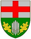
| Blazon : "In a split shield above in silver a red bar cross, below in green five silver organ pipes, accompanied in front and behind by a golden oak leaf." | |
| Justification of the coat of arms: The upper half of the shield reminds of the former affiliation with Kurtrier (Erzstift Trier). The lower half of the shield refers to the former chapel in the parish with the patronage of St. Arnold . St. Arnold was also the patron saint of organists (organ pipes). The oak leaves symbolize the forest and nature around Bonerath. |
Public facilities
In the lower part of the village there is a grill hut with a children's playground and the community center.
Culture and sights
societies
Resident associations are the women's community (since 1986), the support association of the volunteer fire brigade Bonerath e. V. (since 1997), the Heimat- und Kulturverein Bonerath e. V. (since 1998) and the Bonerath youth group (since 2003).
Events
- Spring festival for seniors
- May hike and May festival
- Fair
- Krompernfest
- St. Martin's train
See also
Web links
- Website of the Bonerath parish
- Link catalog on Bonerath at curlie.org (formerly DMOZ )
- To search for cultural assets of the local community Bonerath in the database of cultural assets in the Trier region .
Individual evidence
- ↑ a b State Statistical Office of Rhineland-Palatinate - population status 2019, districts, municipalities, association communities ( help on this ).
- ↑ State Statistical Office Rhineland-Palatinate (ed.): Official directory of the municipalities and parts of the municipality. Status: January 2018 [ Version 2020 is available. ] . S. 76 (PDF; 2.2 MB).
- ↑ State Statistical Office Rhineland-Palatinate - regional data


