
Serrig
| coat of arms | Germany map | |
|---|---|---|

|
Coordinates: 49 ° 34 ' N , 6 ° 34' E |
|
| Basic data | ||
| State : | Rhineland-Palatinate | |
| County : | Trier-Saarburg | |
| Association municipality : | Saarburg-Kell | |
| Height : | 160 m above sea level NHN | |
| Area : | 17.63 km 2 | |
| Residents: | 1662 (Dec. 31, 2019) | |
| Population density : | 94 inhabitants per km 2 | |
| Postal code : | 54455 | |
| Area code : | 06581 | |
| License plate : | TR, SAB | |
| Community key : | 07 2 35 126 | |
| LOCODE : | DE SRA | |
| Association administration address: | Schloßberg 6 54439 Saarburg |
|
| Website : | ||
| Local Mayor : | Egbert Adam ( CDU ) | |
| Location of the local community Serrig in the district of Trier-Saarburg | ||
  |
||

Serrig is a municipality in the Trier-Saarburg district in Rhineland-Palatinate . It belongs to the Saarburg-Kell association.
Geographical location
The wine-growing village is located near Saarburg an der Saar . Parts of the municipality are Domain , House Heiligenborn, Hofgut Serrig, Jagdhaus Neunhäuser (zip code 54314), Saarfels Castle, Serriger Valley, Saarstein Winery and Würtzberg Winery.
history
The area of today's town was probably already settled in Celtic times, as the oldest traditional place name Serviacum from the year 949 indicates. This development is to be seen in connection with the fortified mountain settlement (today: Kastel-Staadt ) on the opposite side of the Saar . Even Roman traces were found in Serrig. At the end of the village upstream of the Saar is the so-called Widderthäuschen , a Roman tomb from the 2nd or 3rd century AD. At that time there were some Roman estates there.
On July 18, 1946, Serrig, together with 80 other communities in the districts of Trier and Saarburg , was annexed to the Saar area , which was separated from the rest of the French occupation zone in February 1946 and which was no longer under the Allied Control Council at the time . On June 6, 1947 this territorial outsourcing was withdrawn to 21 municipalities, so Serrig came to the 1946 newly formed state of Rhineland-Palatinate .
religion
86% of Serrig's residents are Catholic, 6% Protestant. The Catholic parish of St. Martin in Serrig with its neo-Gothic parish church built in 1896 belongs to the deanery of Konz - Saarburg of the diocese of Trier . The Evangelical Church Community of Saarburg in the Trier parish of the Evangelical Church in the Rhineland is responsible for the Protestants .
politics
Municipal council
The local council in Serrig consists of 16 council members, who were elected in the local elections on May 26, 2019 in a personalized proportional representation, and the honorary local mayor as chairman.
The distribution of seats in the local council:
| choice | SPD | CDU | FBL | total |
|---|---|---|---|---|
| 2019 | 3 | 6th | 7th | 16 seats |
| 2014 | 4th | 6th | 6th | 16 seats |
| 2009 | 3 | 6th | 7th | 16 seats |
| 2004 | 3 | 5 | 8th | 16 seats |
- FBL = Free Citizen List Serrig e. V.
Local mayor
After the resignation of the local mayor Franz-Josef Neises after 18 years in office, Serrig elected a new local mayor on April 1, 2012. The candidates were Egbert Adam (CDU) and Ulf Milanese (SPD). Egbert Adam was elected with 51.14% of the vote and appointed mayor on April 20th. Egbert Adam was re-elected on May 25, 2014.
Attractions
The southernmost vineyards on the Saar are located in Serrig, which is why it is known as the “gateway to Saar wine ”. The Riesling variety is grown on over 90 percent of the area under vines .
The townscape is characterized by the Catholic parish church of St. Martin (1895), Saarfels Castle (former sparkling wine cellar), Saarstein Castle and the former state wine-growing domain , which is located above the community in the middle of vineyards. The acreage was cultivated with a field railway (Feuriger Elias) until the 1980s . It is on display today at the entrance to the village, coming from Saarburg.
The Hofgut, a branch of the Lebenshilfe-Werke Trier GmbH, is located in Serrig. It includes living and working places for more than 165 people with and without disabilities. Hofgut Serrig produces meat (pigs, cattle, geese, chickens), fruit and berries, vegetables (potatoes, asparagus, lettuce, ...) according to ecological criteria and has a carpentry, basketry, pottery, vocational training area and several assemblies. The products can be purchased in a farm shop. There is also the Weinbergsfeldbahn, which is operated with the support of Feldbahnfreunde Serrig eV. The Hofgut also offers positions for the “Voluntary Social Year” (FSJ), “Voluntary Ecological Year” (FöJ) and also for the Federal Voluntary Service (Bufdi).
Serrig has one of the largest forest areas in the Saarburg community. In addition to the forestry use, the Serriger Forest is also used for recreation and sporting activities (walking, mountain biking).
See also: List of cultural monuments in Serrig

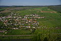
View from the hermitage near Kastel-Staadt to Serrig, northern part
View from the Klause near Kastel-Staadt to Serrig, southern part

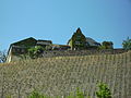
Saarfels Castle Winery
Würtzberg winery

Former state wine-growing domain


Economy and Infrastructure
Viticulture
Serrig belongs to the "Saar winegrowing area" in the Moselle growing region . Eleven wine-growing businesses are active in the village, and the area under vines is 66 hectares. About 97% of the wine grown are white grape varieties (as of 2007).
traffic
Serrig is on the federal road 51 Mettlach - Trier , which was widened and expanded in the 1970s in the course of the Saar canalization . Serrig is also a regional train station on the Saarbrücken - Trier railway line .

The Serrig field railway is operated as a museum railway at Hofgut Serrig .
literature
- Ewald Wegner (arrangement): District of Trier-Saarburg. Verbandsgemeinden Hermeskeil, Kell, Konz, Saarburg (= cultural monuments in Rhineland-Palatinate. Monument topography Federal Republic of Germany . Volume 12.1 ). Wernersche Verlagsgesellschaft, Worms 1994, ISBN 3-88462-100-9 .
Web links
- Former website of the Serrig parish ( memento of March 2, 2001 in the Internet Archive )
- Serrigerland
- Link catalog on Serrig at curlie.org (formerly DMOZ )
Individual evidence
- ↑ State Statistical Office of Rhineland-Palatinate - population status 2019, districts, communities, association communities ( help on this ).
- ↑ State Statistical Office Rhineland-Palatinate (ed.): Official directory of the municipalities and parts of the municipality. Status: January 2019 [ Version 2020 is available. ] . S. 126 (PDF; 3 MB).
- ↑ Sabine Faust: Serrig, "Widderthäuschen": Roman grave building. In: Rheinisches Landesmuseum Trier (ed.): Guide to archaeological monuments of the Trier region. (= Publication series of the Rheinisches Landesmuseum Trier. 35). Trier 2008, ISBN 978-3-923319-73-2 , pp. 170f.
- ↑ 2011 census
- ^ The Regional Returning Officer Rhineland-Palatinate: Local elections 2019, city and municipal council elections. Accessed July 31, 2019 .
- ↑ Serrig Feldbahnfreunde.

Aach | Ayl | Baldringen | Bekond | Notification | Beuren (high forest) | Bonerath | Damflos | Detzem | Ensch | Farschweiler | Fur | Fish | Pine | Franzenheim | Freudenburg | Geisfeld | Greimerath | Grimburg | Gusenburg | Gusterath | Gutweiler | Heddert | Stalling | Herl | Hermeskeil | Hinzenburg | Hinzert-Pölert | Hockweiler | Holzerath | Hedgehog | Irsch | Kanzem | Chasuble | Kastel-Staadt | Kell am See | Kenn | Kirf | Klüsserath | Conc | Cord | Korlingen | Köwerich | Lampades | Langsur | Leiwen | Lunge | Longuich | Lorscheid | Mandern | Mannebach | Mehring | Mertesdorf | Merzkirchen | Morscheid | Naurath (Eifel) | Naurath (forest) | Neuhütten | Newel | Nittel | Upper cheap | Ockfen | Ollmuth | Onsdorf | Osburg | Palzem | Paschel | Pellingen | Pluwig | Pölich | Ralingen | Swift oath | Reinsfeld | Riol | Riveris | Saarburg | Schillings | Schleich | Schoden | Schömerich | Schondorf | Schweich | Serrig | Sommerau | Taben-Rodt | Tawern | Temmels | Thomm | Thörnich | Trassem | Trierweiler | Trittenheim | Vierherrenborn | Waldrach | Waldweiler | Wasserliesch | Wawern | Waves | Welschbillig | Wiltingen | Wincheringen | Zemmer | Zerf | Züsch