
Pellingen
| coat of arms | Germany map | |
|---|---|---|

|
Coordinates: 49 ° 40 ′ N , 6 ° 40 ′ E |
|
| Basic data | ||
| State : | Rhineland-Palatinate | |
| County : | Trier-Saarburg | |
| Association municipality : | Conc | |
| Height : | 461 m above sea level NHN | |
| Area : | 7.22 km 2 | |
| Residents: | 1177 (Dec. 31, 2019) | |
| Population density : | 163 inhabitants per km 2 | |
| Postal code : | 54331 | |
| Area code : | 06588 | |
| License plate : | TR, SAB | |
| Community key : | 07 2 35 106 | |
| LOCODE : | DE LPR | |
| Association administration address: | Am Markt 11 54329 Conc |
|
| Website : | ||
| Local Mayor : | Wolfgang Willems ( CDU ) | |
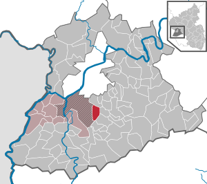
| Location of the local community Pellingen in the district of Trier-Saarburg | ||
  |
||

Pellingen is a municipality in the Trier-Saarburg district in Rhineland-Palatinate . She belongs to the Verbandsgemeinde Konz .
geography
Pellingen is the namesake of the natural spatial unit Pellinger plateau .
Pellingen also includes the districts of the Jagdhütte and Hof Langenstein.
climate
The annual precipitation is 992 mm and is thus in the upper quarter of the values recorded in Germany. Lower values are registered at 84% of the measuring stations of the German Weather Service . The driest month is February, with the most rainfall in November. In November there is 1.5 times more rainfall than in February. The precipitation hardly varies and is very evenly distributed over the year. Lower seasonal fluctuations are recorded at only 9% of the measuring stations .
history
Early history
Paleolithic (around 50,000 BC)
Find a hand ax from the Paleolithic near Wacken. (Source: Landesmuseum Trier )
Neolithic Age (5000–3500 BC)
Fragment of a Neolithic cutting edge under the Celtic princely graves (evidence / source: excavations of the princely graves, Landesmuseum Trier)
antiquity
Bronze Age (2200-800 BC)
Fragment among the Celtic princely graves (evidence / source: excavations of the princely graves, Landesmuseum Trier)
Hallstatt Period (800–450 BC)
Weed seeds in an older settlement layer below the Celtic prince's grave are evidence of the first agricultural activities on the Pellingen plateau. (Source: Excavations of the princely graves, Trier State Museum)
Latène period (450–50 BC)
The oldest finds show that the Pellingen district is to be regarded as a residential area of Celtic indigenous people from the Treveri people . Along an old Celtic traffic axis from today's Saarland via Trier, three barrows were discovered at the "Three Heads", the contents of which - additions for the dead - could be identified as Celtic princely graves (5th to 4th century BC). In particular, the remains of fabric found there give a good insight into everyday life at that time. Etruscan ornaments in the grave goods prove extensive trade relations as far as the Mediterranean area in the pre-Roman times. (Source: Excavations of the princely graves, Trier State Museum)
Roman times
After Julius Caesar had conquered the Trever area, a Roman military road was built over the Pellinger Heights along a presumably old Celtic path, which connected Roman Trier ( Augusta Treverorum ) with the important trading centers of Contiomagus ( Dillingen-Pachten ) and Teulegium ( Tholey ) . A Roman theater mask and a stele with the face of a satyr can still be seen today in the parish church of St. Antonius. The latest excavations show other locations of small Roman settlements in the vicinity of the Roman road . It is not these large country villas like on the Moselle, but small buildings. Maybe they were buildings owned by tenant families? Proven charred remains of wood at these sites show that these buildings were visited during the Germanic invasion around 275 AD.
middle Ages
The first documentary mention was made in 973. Here, Emperor Otto II confirmed the ownership of “Pellinc” = Pellingen to the Oeren ( St. Irminen ) abbey . This naming poses some difficulties for historians, as the place can neither be found before nor after as a property of the Oeren / St.Irminen Abbey. The historian Petrus Becker suspects in the chronicle of the Benedictine abbey that this is to the right of the Olewiger Bach and originally belonged to Pellingen, which later fell under Poppo to the Franzenheim-Ollmuth complex. The church historian Ferdinand Pauly also concludes that the St. Matthias Abbey already had an area for pastoral care in the earliest times, which stretched from the southern city of Trier to far into the Pellingen mountainous region. In 1148 Pope Eugene III confirmed . the abbey their possessions. Here "Pellinc" is mentioned with church and manor. This is also the first evidence of a church in Pellingen. In 1787 Krettnach, Ober- and Niedermennig were separated from the parish of Pellingen. The monastic rule ended with the French Revolution .
Modern times
Pellinger ski jumps
In order to defend the city of Trier against the French revolutionary troops advancing from the Saarlouis fortress , the Pellinger Schanzen were expanded as a line of defense along the old Roman road. In 1792 the French troops could still be repulsed. In the decisive battle on August 8, 1794, the Allied Austrian, Prussian and Trier troops had to surrender to the over 15,000 strong French superiority under General Moreaux . The march of the revolutionary troops into the city of Trier the next day heralded the imminent end of the Electorate of Trier , which in fact went down with the conquest of Koblenz in October 1794 by the French. However, Kurtrier was not officially dissolved until 1803, when the Reichsdeputationshauptschluss closed . Moreaux's name is immortalized on a plaque on the Arc de Triomphe in Paris .
Second World War
On March 1, 1945, advancing US troops took Pellingen.
Population development
The development of the population of Pellingen, the values from 1871 to 1987 are based on censuses:
|
|
politics
Municipal council
The local council in Pellingen consists of 16 council members, who were elected in a personalized proportional representation in the local elections on May 26, 2019 , and the honorary local mayor as chairman.
The distribution of seats in the local council:
| choice | SPD | CDU | FWG | total |
|---|---|---|---|---|
| 2019 | 3 | 9 | 4th | 16 seats |
| 2014 | 1 | 8th | 3 | 12 seats |
| 2009 | 1 | 7th | 4th | 12 seats |
| 2004 | 2 | 5 | 5 | 12 seats |
| 1999 | 2 | 4th | 6th | 12 seats |
- FWG = Free Voting Association Pellingen e. V.
traffic
The federal highway 268 runs through Pellingen from Trier to Saarbrücken , which is also known as Pellinger Strasse in Trier .
Bus line 207 Greimerath goes through Pellingen .
See also
Web links
- Internet presence of the municipality Pellingen
- Literature about Pellingen in the Rhineland-Palatinate State Bibliography
- Short portrait of Pellingen near Hierzuland , SWR television
- To search for cultural assets of the local community Pellingen in the database of cultural assets in the Trier region .
- Link catalog on Pellingen at curlie.org (formerly DMOZ )
Individual evidence
- ↑ a b State Statistical Office of Rhineland-Palatinate - population status 2019, districts, municipalities, association communities ( help on this ).
- ↑ State Statistical Office Rhineland-Palatinate (ed.): Official directory of the municipalities and parts of the municipality. Status: January 2018 [ Version 2020 is available. ] . S. 76 (PDF; 2.2 MB).
- ↑ Heinrich Beyer : Document book on the history of the Middle Rhine territories now forming the Prussian administrative districts of Coblenz and Trier , Volume 1, Coblenz: Hölscher, 1860, ( document 241 )
- ^ Charles B. MacDonald: The Last Offensive . Chapter VII, The Saar-Moselle Triangle, pp. 133 ( online [accessed December 23, 2015]).
- ↑ State Statistical Office Rhineland-Palatinate - regional data
- ^ The Regional Returning Officer Rhineland-Palatinate: Local elections 2019, city and municipal council elections

Aach | Ayl | Baldringen | Bekond | Notification | Beuren (high forest) | Bonerath | Damflos | Detzem | Ensch | Farschweiler | Fur | Fish | Pine | Franzenheim | Freudenburg | Geisfeld | Greimerath | Grimburg | Gusenburg | Gusterath | Gutweiler | Heddert | Stalling | Herl | Hermeskeil | Hinzenburg | Hinzert-Pölert | Hockweiler | Holzerath | Hedgehog | Irsch | Kanzem | Chasuble | Kastel-Staadt | Kell am See | Kenn | Kirf | Klüsserath | Conc | Cord | Korlingen | Köwerich | Lampades | Langsur | Leiwen | Lunge | Longuich | Lorscheid | Mandern | Mannebach | Mehring | Mertesdorf | Merzkirchen | Morscheid | Naurath (Eifel) | Naurath (forest) | Neuhütten | Newel | Nittel | Upper cheap | Ockfen | Ollmuth | Onsdorf | Osburg | Palzem | Paschel | Pellingen | Pluwig | Pölich | Ralingen | Swift oath | Reinsfeld | Riol | Riveris | Saarburg | Schillings | Schleich | Schoden | Schömerich | Schondorf | Schweich | Serrig | Sommerau | Taben-Rodt | Tawern | Temmels | Thomm | Thörnich | Trassem | Trierweiler | Trittenheim | Vierherrenborn | Waldrach | Waldweiler | Wasserliesch | Wawern | Waves | Welschbillig | Wiltingen | Wincheringen | Zemmer | Zerf | Züsch