
Naurath (forest)
| coat of arms | Germany map | |
|---|---|---|

|
Coordinates: 49 ° 46 ' N , 6 ° 53' E |
|
| Basic data | ||
| State : | Rhineland-Palatinate | |
| County : | Trier-Saarburg | |
| Association municipality : | Hermeskeil | |
| Height : | 395 m above sea level NHN | |
| Area : | 5.6 km 2 | |
| Residents: | 218 (Dec. 31, 2019) | |
| Population density : | 39 inhabitants per km 2 | |
| Postal code : | 54426 | |
| Area code : | 06509 | |
| License plate : | TR, SAB | |
| Community key : | 07 2 35 092 | |
| Community structure: | 2 districts | |
| Association administration address: | Langer Markt 17 54411 Hermeskeil |
|
| Website : | ||
| Local Mayor : | Dirk Nabakowski | |
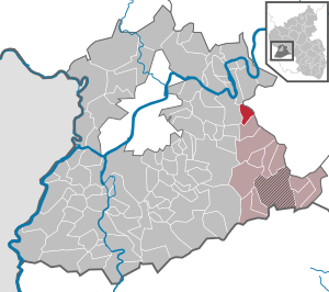
| Location of the local community Naurath (Wald) in the district of Trier-Saarburg | ||
 _in_TR.svg) |
||


Naurath (Wald) is a municipality in the Trier-Saarburg district in Rhineland-Palatinate . It belongs to the Hermeskeil community .
Geographical location
The place above the valley of the Kleine Dhron is eleven kilometers southeast of Schweich and 13 kilometers east of Trier . The Saar-Hunsrück Nature Park is located south of the village . Naurath is connected to the nearby federal motorway 1 through the state road 148 via the Mehring junction .
Neighboring communities are Detzem , Büdlich , Breit , Schönberg , Bescheid and Mehring .
Quarters are Naurath, Unternaurath, the former Naurather mill (stone mill, Robert Mill, now a restaurant trunk Landhaus St. Urban ) and the houses at Büdlicherbrück .
history
In the land register of the Imperial Abbey of St. Maximin (around 1220/30, with additions from the 15th century), Naurath is registered under the name Nuwilre ("new hamlet"), with twenty-four farms ( mansi ) that are subject to duty and service , two mills ( molendina ), two fields ( culturae ) of 33 yokes and a pasture of 6 yokes, also half a courtyard of the abbess Hadewidis von Neumünster.
- Population development
The development of the population of the municipality of Naurath (Wald), the values from 1871 to 1987 are based on censuses:
|
|
|
politics
Municipal council
The local council in Naurath consists of six council members, who in the local elections on May 26, 2019 in a majority vote were elected, and the honorary mayor as chairman.
coat of arms
|
|
Blazon : "Split by blue and gold, three golden ears in front, two red bars behind." |
Culture and sights
Buildings
- Catholic branch church St. Walburga and St. Quirin
- Rock chapel
Regular events
Fun fair in May, summer festival of the volunteer fire brigade in July.
economy
To the west of the village is the Mehringer Höhe wind farm operated by juwi Holding AG with 16 wind turbines in the districts of Mehring (10 systems), Naurath (3) and Bescheid (3).
Web links
- Website of Naurath / Wald
- Link catalog on the subject of Naurath / Forest at curlie.org (formerly DMOZ )
Individual evidence
- ↑ a b State Statistical Office of Rhineland-Palatinate - population status 2019, districts, municipalities, association communities ( help on this ).
- ↑ State Statistical Office Rhineland-Palatinate (ed.): Official directory of the municipalities and parts of the municipality. Status: January 2019 [ Version 2020 is available. ] . S. 118 (PDF; 3 MB).
- ↑ a b Heinrich Beyer u. a .: Document book on the history of the Middle Rhine territories now forming the Prussian administrative districts of Coblenz and Trier. Volume II, Koblenz 1865 ( online at dilibri.de )
- ↑ State Statistical Office Rhineland-Palatinate: My village, my city. Retrieved February 25, 2020 .
- ^ The Regional Returning Officer Rhineland-Palatinate: Local elections 2019, city and municipal council elections.

Aach | Ayl | Baldringen | Bekond | Notification | Beuren (high forest) | Bonerath | Damflos | Detzem | Ensch | Farschweiler | Fur | Fish | Pine | Franzenheim | Freudenburg | Geisfeld | Greimerath | Grimburg | Gusenburg | Gusterath | Gutweiler | Heddert | Stalling | Herl | Hermeskeil | Hinzenburg | Hinzert-Pölert | Hockweiler | Holzerath | Hedgehog | Irsch | Kanzem | Chasuble | Kastel-Staadt | Kell am See | Kenn | Kirf | Klüsserath | Conc | Cord | Korlingen | Köwerich | Lampades | Langsur | Leiwen | Lunge | Longuich | Lorscheid | Mandern | Mannebach | Mehring | Mertesdorf | Merzkirchen | Morscheid | Naurath (Eifel) | Naurath (forest) | Neuhütten | Newel | Nittel | Upper cheap | Ockfen | Ollmuth | Onsdorf | Osburg | Palzem | Paschel | Pellingen | Pluwig | Pölich | Ralingen | Swift oath | Reinsfeld | Riol | Riveris | Saarburg | Schillings | Schleich | Schoden | Schömerich | Schondorf | Schweich | Serrig | Sommerau | Taben-Rodt | Tawern | Temmels | Thomm | Thörnich | Trassem | Trierweiler | Trittenheim | Vierherrenborn | Waldrach | Waldweiler | Wasserliesch | Wawern | Waves | Welschbillig | Wiltingen | Wincheringen | Zemmer | Zerf | Züsch