
District of Trier-Saarburg
| coat of arms | Germany map |
|---|---|

|

Coordinates: 49 ° 42 ' N , 6 ° 41' E |
| Basic data | |
| State : | Rhineland-Palatinate |
| Administrative headquarters : | trier |
| Area : | 1,101.49 km 2 |
| Residents: | 149,398 (Dec. 31, 2019) |
| Population density : | 136 inhabitants per km 2 |
| License plate : | TR, SAB |
| Circle key : | 07 2 35 |
| NUTS : | DEB25 |
| Circle structure: | 104 parishes |
| Address of the district administration: |
Willy-Brandt-Platz 1 54290 Trier |
| Website : | |
| District Administrator : | Günther Schartz ( CDU ) |
| Location of the district of Trier-Saarburg in Rhineland-Palatinate | |
 .svg) |
|

The district of Trier-Saarburg is a regional authority in the west of Rhineland-Palatinate . The seat of the district administration is the independent city of Trier , which is completely surrounded by the district of Trier-Saarburg and is not part of the district. The most populous municipality is the city of Konz . The district of Trier-Saarburg borders the Saarland in the south and the Grand Duchy of Luxembourg in the west .
geography
location
The district of Trier-Saarburg extends from Bitburger Land across the Moselle to the western Hunsrück . In the west the Sûre and the Upper Moselle form the border with Luxembourg . In addition to the Moselle, the Saar and Ruwer are larger rivers in the district . Here is an important German wine-growing region ( Mosel-Saar-Ruwer ). The longest river in the Eifel , the Kyll , flows through the northern district area. The highest mountain in the district is the Sandkopf ( 757 m above sea level ) in the Black Forest high forest .
Neighboring areas
The district borders clockwise in the north, starting with the Eifel district Bitburg-Prüm and the districts Bernkastel-Wittlich and Birkenfeld (all in Rhineland-Palatinate) and the districts of St. Wendel and Merzig-Wadern (both in Saarland ). To the west it borders on the Luxembourg cantons of Remich , Grevenmacher and Echternach .
Spatial planning
After the country's development program, Rheinland-Pfalz (LEP IV) cities are in the district Konz , Saarburg and Hermeskeil as Resource Centers reported. In the regional spatial planning of the Trier region , Schweich , Föhren / Hetzerath, Leiwen , Waldrach / Osburg , Reinsfeld , Kell am See , Zerf , Nittel / Wincheringen and Welschbillig / Trierweiler function as a basic center .
history
The current district area belonged to the Electorate of Trier and the Duchy of Luxembourg until 1794 . From 1798 to 1814 the region was under French administration and was assigned to the Saardepartement , from 1801 it was French national territory . After the Congress of Vienna (1815) the area came to Prussia . They formed in 1816 in Trier , the two circles Trier and Saarburg , excluding the city of Trier, in the province of Lower Rhine (from 1822 Rhine Province ).
After the Second World War , both districts had been part of the French occupation zone since July 1945 . On July 18, 1946, the French military government assigned the entire Saarburg district with a total of 70 communities and 11 communities from the Trier district to the Saar area , which had no longer been under the Allied Control Council since February 1946 . On June 6, 1947, this territorial outsourcing was partially withdrawn, the district of Saarburg thus came to the newly formed state of Rhineland-Palatinate , to which the district of Trier had belonged since 1946. (See also: List of municipalities affected by the connection to Saarland in 1946 )
The district of Trier-Saarburg emerged as part of the district reform in Rhineland-Palatinate on June 7, 1969 from the merger of the district of Saarburg with most of the district of Trier, from which the local communities Ehrang-Pfalzel , Eitelsbach , Filsch , Irsch , Kernscheid , Ruwer , Tarforst and Zewen-Oberkirch were incorporated into the city of Trier, the local parishes of Minden and Menningen moved to the district of Bitburg and the local community of Börfink-Muhl moved to the district of Birkenfeld .
In the second phase of the district reform, the Trier-Saarburg district handed over the local communities Breit , Büdlich , Heidenburg and Trittenheim to the Bernkastel-Wittlich district and the local communities Eisenach , Gilzem and Orenhofen to the Bitburg-Prüm district on November 7, 1970 . On January 1, 2012, the local community of Trittenheim moved from the district of Bernkastel-Wittlich back to the district of Trier-Saarburg.
The district has been part of the Trier Region Initiative (IRT) since 1994 , in which regional public institutions, administrations, universities, companies, banks and committed individuals aim to make the region an economically attractive, culturally significant and ecologically intact area with a high life - and to secure recreational value, work together as partners.
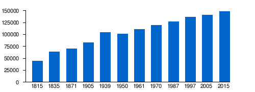
Population development
The development of the number of inhabitants in relation to today's area of the Trier-Saarburg district, the values from 1871 to 1987 are based on censuses:
|
|
Graphic of the population development
|
politics
District council
The district council of the district of Trier-Saarburg consists of 50 honorary district council members elected in a personalized proportional representation and the district administrator as chairman. After the last district election on May 26, 2019 , the following distribution of seats results:
| year | SPD | CDU | Green | FDP | left | AfD | Pirates | Total flat share | Seats | Turnout in percent |
|---|---|---|---|---|---|---|---|---|---|---|
| 2019 | 10 | 17th | 8th | 2 | 2 | 3 | - | 8th | 50 | 66.5 |
| 2014 | 11 | 20th | 4th | 1 | 1 | 1 | 1 | 7th | 46 | 59.9 |
| 2009 | 12 | 19th | 4th | 3 | - | - | - | 8th | 46 | 61.2 |
| 2004 | 12 | 22nd | 3 | 2 | - | - | - | 7th | 46 | 63.8 |
| 1999 | 17th | 23 | 2 | 0 | - | - | - | 4th | 46 | 70.0 |
District administrators
- 1969–1983: Dieter Braun-Friderici
- 1983–2005: Richard Groß (CDU)
- since January 1, 2006: Günther Schartz (CDU)
Günther Schartz was confirmed in his office for a further eight years in the direct election on September 22, 2013 with a share of 60.6% of the votes.
badges and flags

Hoist flag

Banner flag

The district of Trier-Saarburg has a coat of arms as well as a hoist and banner flag .
|
|
Blazon : "Nine times divided by silver and blue, covered by a continuous red cross, which is covered with a golden heart shield, in it a red battlement castle with a pointed turret pushed forward on a black mountain." |
| Justification of the coat of arms: The red cross stands for the Electorate of Trier , the silver-blue shield division is taken from the coat of arms of Luxembourg and the castle symbolizes the Saarburg , which is taken from the city coat of arms of the city of the same name. The coat of arms was approved on March 31, 1970. |
District partnerships
The district of Trier-Saarburg maintains three partnerships:
-
 Puck County ( Poland ), since 2001
 -
 District of Saalfeld-Rudolstadt ( Thuringia ), since 1990
 -
 Kibuye ( Rwanda ), since 2002
Economy and Transport
In the Future Atlas 2016 , the district of Trier-Saarburg was ranked 288 out of 402 districts, municipal associations and independent cities in Germany, making it one of the regions with a "balanced risk-opportunity mix" for the future.
Street
The federal highway 1 Saarbrücken-Trier-Cologne, the federal highway 64 Trier-Luxembourg and the federal highway 602 , which connects these highways, run through the district area . Furthermore, the district area is accessed by several federal , state and district roads. The federal highways in the district are the B 49 , B 51 , B 52 , B 53 , B 268 , B 407 , B 418 , B 419 and the B 422 .
rail
Rail connections in the district are the Moselle route Koblenz- Trier and the Saar route as an extension of it along the Saar via Konz and Saarburg to Saarbrücken . The Mosel-Syretal route leads via the border station Igel (Mosel) to Luxembourg.
Important regional train stations are in Schweich and Konz
There is also the Thionville – Trier railway from Konz along the Moselle to Thionville in France, which is particularly used for freight traffic . This route, also known as the Obermoselbahn , is also served by local rail transport - mostly to Perl . The Ruwertalbahn from the Trier district of Ruwer-Eitelsbach via Waldrach and Zerf to Hermeskeil was abandoned and converted into the Ruwer-Hochwald cycle path .
Nature reserves

There are 22 nature reserves in the Trier-Saarburg district, two of which are partly in the area of the city of Trier. Biotopes that are worth protecting are orchid biotopes, some of which are of European standing, wetlands, floodplains, limestone grasslands, sloping moors, near-natural stream valleys, rocky biotopes, etc.
Castles and Palaces


The district has a number of castles and palaces:
- Klause bei Kastel , Celtic refugee castle
- Grimburg Castle , Grimburg
- Ramstein Castle , Kordel (Eifel)
- The Saarburg , Saarburg
- Welschbillig Castle , Welschbillig
- Sommerau castle ruins , Sommerau
- Föhren Castle by those of Kesselstatt
- Föhren Castle (Prümer Hof)
- Marienlay Castle , Morscheid
- Grünhaus Castle , Mertesdorf
- Freudenburg castle ruins
- Feller Maximiner Castle
- Longuich old castle
- Warsberg Castle , Saarburg
- Saarfels Castle, Serrig
- Saarstein Castle , Serrig
- Thorn Castle , Palzem
- Heid Castle , Schillingen
- Wasserburg Klüsserath , Klüsserath
- Warsberg Castle , Wincheringen
- Osburg Castle
- Castle Ayl , Ayl
Culture
Museums
The open-air museum Roscheider Hof is located in Konz directly on the boundary of Trier and was opened in 1973 a. a. founded by the district of Trier-Saarburg and the cities of Trier and Konz.
Medical supplies
The district is responsible for the district hospital St. Franziskus Saarburg gGmbH .

St. Francis District Hospital

overall view


Communities
(Residents on December 31, 2019)


Associated municipalities , structured according to the administrative allocation to the association municipalities :
(Administrative seat of the association *)
Former parishes
The following municipalities have lost their independence since the district was founded in 1969:
|
|
For lists of the term "area changes" see area reforms in Rhineland-Palatinate
License Plate
On June 7, 1969, the district was assigned the TR distinguishing mark , which had been valid for the Trier district since July 1, 1956 . It is still issued today. Since November 19, 2012, due to the license plate liberalization , the SAB distinguishing mark of the former Saarburg district has been available again.
literature
- Ewald Wegner (arrangement): District of Trier-Saarburg. Verbandsgemeinden Hermeskeil, Kell, Konz, Saarburg (= cultural monuments in Rhineland-Palatinate. Monument topography Federal Republic of Germany . Volume 12.1 ). Wernersche Verlagsgesellschaft, Worms 1994, ISBN 3-88462-100-9 .
- Ewald Wegner (arrangement): District of Trier-Saarburg. Verbandsgemeinden Ruwer, Schweich, Trier-Land (= monument topography Federal Republic of Germany , cultural monuments in Rhineland-Palatinate . Volume 12.2 ). Wernersche Verlagsgesellschaft, Worms 1994, ISBN 3-88462-110-6 .
Web links
- Website of the district of Trier-Saarburg
- Statistical data for the district of Trier-Saarburg from the State Statistical Office of Rhineland-Palatinate
- Literature from and about the district of Trier-Saarburg in the catalog of the German National Library
- Literature on the district of Trier-Saarburg in the Rhineland-Palatinate state bibliography
- Link catalog on the Trier-Saarburg district at curlie.org (formerly DMOZ )
Individual evidence
- ↑ State Statistical Office of Rhineland-Palatinate - population status 2019, districts, communities, association communities ( help on this ).
- ↑ Planning Community Trier Region ( Memento from March 4, 2016 in the Internet Archive ) (PDF; 2.5 MB), Internet archive
- ↑ Official municipality directory 2006 ( Memento from December 22, 2017 in the Internet Archive ) (= State Statistical Office Rhineland-Palatinate [Hrsg.]: Statistical volumes . Volume 393 ). Bad Ems March 2006, p. 166 (PDF; 2.6 MB). Info: An up-to-date directory ( 2016 ) is available, but in the section "Territorial changes - Territorial administrative reform" it does not give any population figures.
- ↑ State Statistical Office Rhineland-Palatinate - regional data
- ^ The regional returning officer RLP: Landkreis Trier-Saarburg. Final result of the 2019 district council election. Accessed August 10, 2019 .
- ^ Trier-Saarburg district: Günther Schartz (CDU) re-elected as district administrator. September 22, 2013, accessed December 7, 2019 .
- ↑ 10 years of district partnership with the Polish district of Puck
- ↑ Partnership Saalfeld-Rudolstadt
- ^ Partnership Kibuye Rwanda
- ↑ Future Atlas 2016. Archived from the original on October 2, 2017 ; accessed on March 23, 2018 .
- ↑ Ruwer-Hochwald-Radweg: Homepage. In: ruwer-hochwald-radweg.de. September 5, 2014, accessed March 2, 2015 .
- ↑ State Statistical Office of Rhineland-Palatinate - population status 2019, districts, communities, association communities ( help on this ).
Districts:
Ahrweiler |
Altenkirchen (Westerwald) |
Alzey-Worms |
Bad Dürkheim |
Bad Kreuznach |
Bernkastel-Wittlich |
Birkenfeld |
Cochem cell |
Donnersbergkreis |
Eifelkreis Bitburg-Prüm |
Germersheim |
Kaiserslautern |
Kusel |
Mainz-Bingen |
Mayen-Koblenz |
Neuwied |
Rhine-Hunsrück District |
Rhein-Lahn district |
Rhine-Palatinate District |
Southern Wine Route |
Southwest Palatinate |
Trier-Saarburg |
Vulkaneifel |
Westerwaldkreis
Independent cities:
Frankenthal (Pfalz) |
Kaiserslautern |
Koblenz |
Landau in the Palatinate |
Ludwigshafen am Rhein |
Mainz |
Neustadt an der Weinstrasse |
Pirmasens |
Speyer |
Trier |
Worms |
Zweibrücken