Orenhofen
| coat of arms | Germany map | |
|---|---|---|

|
Coordinates: 49 ° 54 ' N , 6 ° 39' E |
|
| Basic data | ||
| State : | Rhineland-Palatinate | |
| County : | Eifel district Bitburg-Prüm | |
| Association municipality : | Storage | |
| Height : | 355 m above sea level NHN | |
| Area : | 12.04 km 2 | |
| Residents: | 1315 (Dec. 31, 2019) | |
| Population density : | 109 inhabitants per km 2 | |
| Postal code : | 54298 | |
| Area code : | 06580 | |
| License plate : | BIT, PRÜ | |
| Community key : | 07 2 32 289 | |
| Association administration address: | Bahnhofstrasse 36 54662 Speicher |
|
| Website : | ||
| Local Mayor : | Wolfgang Horn | |
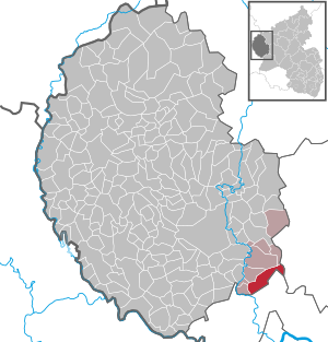
| Location of the local community Orenhofen in the Eifelkreis Bitburg-Prüm | ||
Orenhofen near the Kyll Valley in the Eifel is a municipality in the Eifelkreis Bitburg-Prüm in Rhineland-Palatinate . It belongs to the collective municipality of Speicher and is one of the Fidei locations .
geography
The local community is located in the natural and cultural landscape of the southern Eifel , near the district town of Bitburg .
history
Orenhofen was mentioned in a document as early as 953 as the property of the Oeren Abbey (called St. Irminen ). The manor and bailiwick were exercised by the St. Irminen Abbey. Until the end of the 18th century, Orenhofen belonged to the Luxembourg rule Scharfbillig and from 1798 belonged to the canton of Dudeldorf in the forest department . Then Orenhofen came to Prussia and in 1946 after the constitution of the state to Rhineland-Palatinate. Since November 7, 1970, Orenhofen has belonged to the Verbandsgemeinde Speicher because of a reorganization. before that there was an administrative affiliation to the Schleidweiler-Rodt office in Zemmer.
The discovery of broken fragments shows that there was a pottery in Orenhofen in Roman times. Pottery is an old reminder of a branch that no longer exists today. Iron ore deposits were exploited around 1850/1860. However, due to the low iron content of the stones, mining was hardly worthwhile. A so-called "pipe furnace" stood in Orenhofen until well into the first half of the 20th century. Clay pipes in particular were made in it.
Orenhofen belonged to the district of Trier-Saarburg until November 7, 1970 and was incorporated into the district of Bitburg-Prüm , which was newly formed on the same date .
- Population development
The development of the population of Orenhofen, the values from 1871 to 1987 are based on censuses:
|
|
politics
Municipal council
The municipal council in Orenhofen consists of 16 council members, who were elected in a personalized proportional representation in the local elections on May 26, 2019 , and the honorary local mayor as chairman.
The distribution of seats in the municipal council:
| choice | SPD | CDU | FWG | total |
|---|---|---|---|---|
| 2019 | 8th | 4th | 4th | 16 seats |
| 2014 | 5 | 5 | 6th | 16 seats |
| 2009 | 5 | 6th | 5 | 16 seats |
| 2004 | 5 | 5 | 6th | 16 seats |
coat of arms
| Blazon : "Divided from silver over blue obliquely to the left, in front a blue arrowhead turned obliquely to the right, behind a golden rose." | |
| Justification of the coat of arms: The Oeren Abbey was patronized by St. Mary, who also has an old abbey seal. Its symbol, the golden rose, is in the lower part of the shield. As early as 1570, the visitation report in Orenhofen lists a Sebastianus chapel. It must have existed earlier, as a bell that was cast in 1522 and was later melted down is indicated. The arrow in the upper field is the symbol of St. Sebastianus. Today's patron, St. Rochus, was not accepted until the new church was built in 1873. |
Culture and sights
Buildings
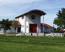
- Catholic parish church of St. Roch from 1877
- Path chapel from the 18th or 19th century with a niche cross from the 16th century
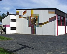
- Bürgerhaus - a former boys' school with a teacher's apartment from 1893
- Former girls' school from 1877
- The town center is the location of several historic houses and old farms .
See also: List of cultural monuments in Orenhofen
Green spaces and recreation
- Motte - an early medieval tower hill castle
- There are some - some very old - crossroads spread across the municipality .
- The Schönfelder Hof and the Rothaus Inn are easy to reach via the bike and hiking trail along Landesstraße 2.
See also: Motte Orenhofen
Regular events
- Annual fair or parish fair
- Traditional rattling or rattling on Good Friday and Holy Saturday
- Hut burning on the first weekend after Ash Wednesday (so-called Scheef Sunday)
photos
Web links
- Ortgemeinde Orenhofen on the website of the Verbandsgemeinde Speicher
- To search for cultural assets of the local community Orenhofen in the database of cultural assets in the Trier region .
- Portrait and TV report about Schönfelder Strasse in Orenhofen
Individual evidence
- ↑ a b State Statistical Office of Rhineland-Palatinate - population status 2019, districts, municipalities, association communities ( help on this ).
- ↑ State Statistical Office Rhineland-Palatinate (ed.): Official directory of the municipalities and parts of the municipality. Status: January 2019 [ Version 2020 is available. ] . S. 105 (PDF; 3 MB).
- ↑ Official municipality directory (= State Statistical Office of Rhineland-Palatinate [Hrsg.]: Statistical volumes . Volume 407 ). Bad Ems February 2016, p. 150 (PDF; 2.8 MB).
- ↑ State Statistical Office Rhineland-Palatinate: My village, my city. Retrieved February 11, 2020 .
- ^ The Regional Returning Officer Rhineland-Palatinate: Local elections 2019, city and municipal council elections. Retrieved February 11, 2020 .
- ↑ Description of the coat of arms. Verbandsgemeinde Speicher, accessed on February 11, 2020 .
- ↑ Hüttenbrennen in the Eifel. Retrieved May 1, 2016 .
- ↑ Hut Sunday in the Eifel. Retrieved August 10, 2017 .


