
Kelsen (Merzkirchen)
|
Kelsen
Local church Merzkirchen
|
|
|---|---|
 |
|
| Height : | 334 (280-350) m above sea level NHN |
| Residents : | 170 |
| Incorporation : | March 16, 1974 |
| Postal code : | 54439 |
| Area code : | 06582 |
 View over an old village well
with a temporary cross to the church of St. Gangolf |
|
Kelsen is a district of the Rhineland-Palatinate municipality Merzkirchen in the district of Trier-Saarburg .

geography
Kelsen is located on the eastern slope of the Saargau on the border with Saarland . The eponymous Kelsbach flows through the locality and also rises here in a contained spring. The hilly landscape is used for agriculture and is characterized by pastureland, arable land and orchards, forest covers only a small part of the district area. The closest places are Portz (district of Merzkirchen) in the north, Meurich (district of Kirf ) in the south and Merzkirchen in the northwest. The district roads K 120 (Merzkirchen - Meurich) and K 122, which connect to the K 121 (Portz - Trassem ), lead through the village .
history
Due to the construction of a Roman road Trier - Metz , which led past one and a half kilometers away in about a settlement was made possible in the district Kelsen since the 1st century. Evidence of this is given by three Roman manors from the 1st to 4th centuries, one of which can be proven in the location. In addition, richly furnished graves from the Frankish period (3rd to 9th centuries) have been excavated on the Pelmberg , the finds of which can now be viewed in the Rheinisches Landesmuseum in Trier.
The first written mention of the place as Kelse took place in the 12th century, in 1488 Kelsen already had its current name. The oldest surviving houses in the village, which was laid out as a street village, date from the early 19th century.
On July 18, 1946, the former municipality of Kelsen, together with 80 other municipalities in the districts of Trier and Saarburg , was annexed to the Saar area , which was separated from the rest of the French occupation zone in February 1946 and which at that time was no longer under the Allied Control Council. On June 6, 1947, this territorial outsourcing was withdrawn to 21 municipalities, so that Kelsen came to the 1946 newly formed state of Rhineland-Palatinate .
On March 16, 1974, the previously independent community of Kelsen was combined with five other communities to form the local community of Merzkirchen in the form of a new formation. The mayor of Kelsen is Gerhard Peter.
Before the new community was formed, Kelsen had 104 inhabitants.
coat of arms
|
|
|
| Justification of the coat of arms: The red cross on a white background in the head of the shield symbolizes Kurtrier as a former sovereign. The gray lion's head on a black background with the red tongue popping out stands for the Warsberg house , which has been the landlord in Kelsen for a long time since 1258. |
The coat of arms was introduced in 1967, it comes from Ernst Steffny.
economy
While Kelsen still had 131 inhabitants in 1787, mainly farmers and forest workers, more recently there are only about 80, whose branches of business are tourism with the rental of holiday apartments and the modest trade in fruit , honey , distillery products and cattle .
Worth seeing
St. Gangolf Church
Predecessor chapel Simon and Judas
The beginnings of the Kelsen church can be found in the church records of Kirf , because Kelsen was a branch of Kirf until 1859. In 1657 a visitation report reported about a dilapidated chapel, so that it can be assumed that the chapel already existed at the time of a visit in 1569. In several reports, the Simon and Judas chapel , which stood on a hill down the slope ( location → ), was mentioned as dilapidated; it had to be demolished in 1906 because of moisture and dilapidation.
Today's Church of St. Gangolf
Already in 1873 a plot of land was acquired for the new church ( location → ). Since 1905 the pastor refused to hold mass in the old, wet and dilapidated chapel. Valuable parts of the chapel were used in the construction of the new church, which was consecrated to St. Gangolf on February 27, 1909 . The architect Peter Marx from Trier and the building contractor Theodor Horbach from Trier created a simple rectangular building facing west and measuring 15.2 by 7.8 meters. The two-storey tower is 9.6 m high and 3 m wide, you enter the church through it. The ground floor is open on all sides and has a groined vaulted ceiling . A narrow window on the tower ground floor lets only little light into the interior. The bell room with the bronze bell from 1801 on the upper floor has an octagonal Welsche dome and has several sound arcades . The ship is 9.60 m long and 6.10 high and has an ogival ceiling. The retracted choir is 3.60 m by 6.40 m tall. The gable wall is straight. Inside the ship, the ogival ceiling is 6.10 m high. The ship is illuminated through four wide windows with central pillars and tracery made of red sandstone. They have diamond glazing with a decorative border. The choir has two narrow windows with depictions of the kneeling and the dying St. Gangolf (1907). The bell is rung automatically, the bells of the other districts of Merzkirchen are still rung by hand.
The baroque altar stands on a pedestal. The block-like action, approximately 2 m wide and less than 1 m high altar table indicates the front four segments, the plastically with ornaments, pinnacles and ogival - Three passes are provided. On the altar table is a 20 cm thick candlestick bench and on top of it the older part of the altar from the 18th century. A three-part rotating tabernacle forms the center of this altar part. On a pedestal with the All-Seeing Eye of God stands a figure of St. Gangolf, a terracotta cast from 1935 from the workshop of the Trier sculptor Carl Walter. At his feet is a model of the St. Gangolf Church in Trier. On both sides of the middle part of the altar are the 95 cm high, colorful terracotta figures of the earlier patrons Simon and Judas, at which St. Gangolf looks down. They come from the old chapel and are dated to 1866. The church also houses two statues of the Mother of God (1887 and 20th centuries), St. Joseph (1887) and Christ (20th century) as well as a Pietà (1887) and a Stations of the Cross with 14 stations from the early 20th century . Behind the altar is the oak confessional.
Next to the chapel entrance there is a sandstone memorial plaque with the villagers who died or were missing in the two world wars. Church and its surroundings have been a listed building since 1992. In 1912 six linden trees were planted in front of the church, of which only three remained in 1963. Today there are only two that are under nature protection. The ensemble forms a prominent point in the townscape.
- Pictures of the church

View of the chancel

Art Nouveau church window with the patron St. Gangolf, in whose chest a knife is stuck

Gangolf kneeling with sword
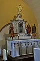
Altar, at the top St. Gangolf

South-east entrance gate to the churchyard


Other sights


- Keysbrunnen : a system built in 1873 with five washing and drinking basins, but with a different layout than today. An equipment room was also partitioned off here to accommodate fire engines and fire fighting equipment . The source of the Kelsbach, which was set in earlier times, feeds the system. In 1908 a daily spring discharge of 75 m² of pure water was measured . After the Second World War, the facility was rebuilt: four troughs without the washing facility now form a small village square where people meet and where a fountain festival has been held every three years since 1983, offering local delicacies such as Viez or ham sandwiches. The guests are entertained with music from local choral and music associations.
- Windloch orchids location with orchid , Nestwurz , twayblade and Daphne in the south of the town. A small temple is said to have stood here in Roman times.
- Hawthorn , sloe and dry grass can be found in the abandoned quarry outside the village .
- House No. 15: Quereinhaus , northeast of the church ( Location → ) Plastered building under a slate-covered half-hip roof . An inscription indicates that it was built in 1867. The facade structure is characterized by pilaster strips as a frame and a plaster eaves. The basement ceiling is above street level, so that the house is entered via three entrance steps. The windows sit on a narrow cornice on the ground floor, the frames of the windows are made of red sandstone. The neighboring business section shows a wicker-arched wide barn door, a stable door and above a barn floor for feed and grain. The property is well preserved and was restored in 1992. In front of the property you enter an old paved courtyard area.
- At the western exit of the village on the K 120 ( Lage → ) the war memorial cross ("Büchelkreuz") stands on a three-part sandstone pedestal made of cube-shaped elements. A modern cast-iron crucifix stands on the top piece. The front of this cube bears a relief depicting an iron cross with oak leaves. The basis for the cubes is a sandstone block that is embedded in the earth. The cross was erected in honor of Matthias Büchel, who fell at the age of 22 on June 19, 1915 in Nennig . The iron cross was renewed in 1992.
- On the dirt road to Portz, which initially runs parallel to the K 122, there is another stone cross on the left side of the path, the Bennings Cross ( Location → ). The upper part contains the Christ monogram (XP). The cross was about 2.10 m high and is incomplete today: the part of the inscription is missing. This part was taken into custody by the former property owner named Benning and placed in his garden. The stone originally came from the Kelsen cemetery and landed here on the meadow after the churchyard had become too small. It is the tombstone of Benning's grandmother, as evidenced by the inscription: JESU MARIA JOSEF AÑA Anna Benning from Kelsen, virgin died July 22, 1866, aged 32 years . The block of inscriptions has disappeared today, the inscription was copied by the Kelsen restorer and local history researcher Ernst Steffny around 2000.
See also
literature
- Ernst Wackenroder : The art monuments of the Saarburg district . (= Paul Clemen (Hrsg.): Die Kunstdenkmäler der Rheinprovinz , Volume 15, III. Department). L. Schwann, Düsseldorf 1939 (reprint from the Academic Bookshop Interbook, Trier 1982), p. 124.
- Ernst Steffny and Clemens Lehnert: Merzkirchen - a chronicle. Merzkirchen 2012, ISBN 978-3-00-037531-6 .
Web links
- To search for cultural assets in the Kelsen district of the Merzkirchen municipality in the database of cultural assets in the Trier region .
Individual evidence
- ↑ a b Official municipality directory 2006 ( Memento from December 22, 2017 in the Internet Archive ) (= State Statistical Office Rhineland-Palatinate [Hrsg.]: Statistical volumes . Volume 393 ). Bad Ems March 2006, p. 187 (PDF; 2.6 MB). Info: An up-to-date directory ( 2016 ) is available, but in the section "Territorial changes - Territorial administrative reform" it does not give any population figures.