
Saargau
.jpg)
Saargau denotes on the one hand a Franconian district and on the other the ridge between the Saar and the Moselle or in the southern area between the Saar and the French border.
Saargau county
The Saargau was a Franconian county that is already documented for the year 699 and at that time also included the part of the Saar valley that is now in France. In the Treaty of Meersen ( 870 ) two Saar counties are named, comitatus Sarachuua inferior (Lower Saargau) around Merzig and comitatur Sarachuua subterior (Upper Saargau) around Sarrebourg , of which only the Lower Saargau continued the name Saargau in the late Middle Ages. The lower Saargau was ecclesiastically part of the Archdiocese of Trier , the upper Saargau to the diocese of Metz . In Carolingian documents, in addition to the Upper and Lower Saargau, the Bliesgau, Niedgau, Albegau and Rosselgau are named as Gau counties on the Saar. The boundaries of the individual districts are difficult to determine. For the Bliesgau , which is bounded by the Köllertal Forest and the Palatinate Mountain Forests , the location information is relatively numerous. The counties seem to have dissolved very early on. The tradition in the period between the 10th and the 12th centuries with few documents makes researching the situation difficult.
Saargau landscape
The Saargau is a mountain range west of the Saar . It begins in the south at Berus , runs along the French border to the north, from Saarland across to neighboring Rhineland-Palatinate . The northern part is bounded in the west by the Moselle and ends at Konz , where the Saar flows into the Moselle.
The eastern edge of the Saargau slopes steeply in the Saarland part towards the Saar valley. To the west, towards Lorraine and beyond the national border, the Gaulandschaft is rather flat and wide, with gentle waves and hills. Geologically, the Saargau belongs to the Lothringer stepland , which has a steep step every few kilometers, from west to east, and rises barely noticeably between every two such steps. Wine is grown on the western foothills of the Saargau near the Moselle. Above all, the Elbling grape variety grows here .
The Gau landscape is largely shaped by the heavy shell limestone soil. In the area of Borg , Oberleuken , Büschdorf , Eft-Hellendorf , Sinz , Münzingen , Kesslingen and Faha , there is a pronounced agriculture. One speaks here of the Saarland's granary . This area, which is heavily influenced by arable farming, also extends into the neighboring Rhineland-Palatinate to the north , especially in the area of Merzkirchen , Fisch and Mannebach (near Saarburg) . In addition, orchards can be found everywhere and, to a lesser extent, in the towns of Tettingen - Butzdorf and Borg there is commercial fruit growing. Viezstraße leads across the Saargau . The eastern foothills of the Saargau are mostly overgrown with forest on the steep slopes that descend towards the Saar. In the northern area from Saarburg also with wine. The well-known Rhineland-Palatinate Saar Riesling thrives here .
In its northern part, the Saargau reaches heights of around 400 meters above sea level ( Nitteler Höcht 390 m above sea level, Helenenkreuz near Wincheringen 413 m above sea level), further south of around 450 meters (Eiderberg near Freudenburg 440 m above sea level, Kewelsberg near Tünsdorf 442 m above sea level)
Attractions
- Beckingen : large nature reserve "Wolferskopf" with "Fischerberghaus" (orchids, herd of suckler cows with Vosges cattle , circular hiking trails)
- Berus: Remains of the medieval city fortress, parish church of St Martin, European monument , Oranna chapel
- Borg: Reconstructed Roman Villa Borg
- Felsberg: Teufelsburg and Felsberg-Berus transmitter
- Gisingen : Museum "Haus Saargau"
- Him: Roman spring shrine on the Sudelfels
- Kastel-Staadt: Klause Kastel high above the Saar
- Niedaltdorf: Niedaltdorf stalactite cave
- Orscholz: viewpoint on the Saar loop
- Siersburg : Siersburg Castle. Valley of the Nied
- St. Barbara : Roman copper mine
- Wellingen: sculpture symposium " stones at the border "
photos
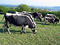
At the " Wolferskopf " with a view of the Saargau
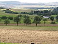
Saargau near Kerlingen ...

... and at Merzkirchen
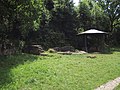
Sudelfels spring shrine
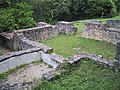
Ruins of the Roman cult site in Him

Oranna Chapel near Berus
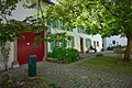
Lorraine House in Gisingen


.jpg)
Web links
Individual evidence
- ↑ Hans-Walter Herrmann: History of the County of Saar Werdenb up to 1527, 2 volumes (Publications of the Commission for Saarland State History and Folk Research 1), Saarbrücken 1957-1960, Vol. 1, No. 1a.
- ^ Josef Niessen: On the territorial history of the Saarland, in: Hermann Overbeck u. Georg Wilhelm Sante: Saar Atlas, Gotha 1934, pp. 43–49, here p. 49.
- ↑ Monumenta Germaniae Historica , Capitularia 2, pp. 193–195, no. 251.
- ↑ Johannes Hoops, Heinrich Beck (Ed.): Reallexikon der Germanischen Altertumskunde . tape 26 . Walter de Gruyter, Munich 2004, ISBN 978-3-11-017734-3 , p. 12 ( google.de ).
- ^ Josef Niessen: On the territorial history of the Saarland, in: Hermann Overbeck u. Georg Wilhelm Sante: Saar Atlas, Gotha 1934, pp. 43–49, here p. 49.