
Saar loop

|


The Saar Bow is in contrast to the little ones Saarschleife in Hamm (a district of Taben-Rodt ) and Great Saar loop at Mettlach called a transverse valley of the Saar by the Taunus quartzite and is one of the most famous sights of Saarland . The most popular view is the Cloef viewpoint, 180 m high above the river, in the Orscholz district of Mettlach . The bank is formed by rock faces, rubble heaps and small ravines.
location
The Saar loop begins shortly after the Merzig district of Besseringen and ends in Mettlach. The air line between Besseringen and Mettlach is only about two kilometers. However, the Saar makes a detour that is almost ten kilometers.
The former monastery church of St. Gangolf with parts of the former monastery complex and the castle ruins of Montclair are located on the wooded ridge within the Saar loop . The only place directly on the Saarschleife is the village of Dreisbach , to which you can take a ferry.
There is a continuous hiking and cycling path on both the inside and the outside loop . An area of around 100 hectares west of the Saarschleife is under nature protection as Steinbachtal west of the Saarschleife .
geography
The narrowing of the Saar loop between Besseringen and Dreisbach is due to the fact that the Saar , which comes from the red sandstone of the Merzig basin, enters a section of hard quartzite rock here . It is not exactly clear why the Saar did not manage to choose the direct route between Besseringen and Mettlach in the past. One possibility would be that the Saar followed fissures of the Devonian quartzite, i.e. a weak zone, on its way . The pursuit of a weak rock over a length of more than two kilometers would be unusual, however. Investigations showed that in the Saar loop and its surroundings, the red sandstone is only unevenly superimposed on the quartzite below. When it was formed, the red sandstone did not cover a previous level, but rather buried an existing relief. The quartzite crevice must have existed earlier and the red sandstone that lay on top of it was cleared away by the waters of the Saar at this point. Together with the great Mettlacher Saarmäander, the Saar loop deepened at a later mountain elevation. The gradual incision of the Saar is clearly recognizable if you look at the terraced sliding slope opposite from the Cloef, i.e. the rock above the turning point of the Saar loop on the Prallhang .
This mountain spur surrounded by the Saar is 4 km long and at its highest point is 318 m above sea level , while the level of the Saar water is around 166 m above sea level. The entire area around the Saar loop is largely forest-covered. The forest is largely natural. A red beech forest usually grows on the red sandstone remains of the Saarschleife . Hornbeams and oaks predominate on the quartzite . On the steep slopes, the woods merge into a bush forest of hornbeam and oak. Due to the favorable climate, the evergreen sub-Mediterranean-Atlantic European holly also grows here . Only lichens and mosses settle on the so-called “Rosseln”, the scree slopes created by weathering.
Anthropogenic use


The favorable location of the mountain spur around it prompted the Celtic indigenous population to build a protective wall two kilometers east of the medieval castle ruins of Montclair. The mountain spur of the Saar loop was probably used as a Celtic refuge. Traces of the Romans on the steep slope facing the sun are detectable. After the fall of the Roman Empire in the migration of peoples and the establishment of Frankish rule , an Ardennes noble family built Skiva Castle (also Skipha or Sissiva) on the mountain spur around the year 1000. There were constant conflicts with the Archbishops of the Archdiocese and Archbishopric of Trier , who were feudal lords . Around the year 1016 the Archbishop of Trier Poppo von Babenberg succeeded in conquering and destroying the castle complex.
It was not until two hundred years later that Archbishop Arnold I of Trier permitted the construction of a new castle complex in 1180. The construction of this castle, called Montclair (Mons clarus, Heller Berg), was completed in 1190. The castle complex came to the Dukes of Lorraine in the course of time . The castle was destroyed in 1351 in a conflict between the dukes of Lorraine and the Archbishopric of Trier. It was not until 1426 that the noble dynasty of the Lords of Sierck received the right to build a much smaller castle on the Saarschleifenbergsporn. This second Montclair castle fell into ruin after 1620. In 1661, the French King Louis XIV agreed with the Archbishop of Trier, Karl Kaspar von der Leyen , that the Montclair castle ruins should not be rebuilt, as they would have been usable in the event of war against the Kingdom of France . Thus the ruin of the castle progressed. It was not until the 19th century that the preserved remains began to be secured. The initiator of the conservation measures was the Prussian King Friedrich Wilhelm IV , who stayed in Mettlach for the first time in 1835.
In the time of National Socialism , Adolf Hitler's plan existed to build a "Reichsschulungsburg" on the wooded Montclair ridge, which would have taken up 170 hectares. A Thingstätte for 4000 people, a tower, a “Hall of Honor for the Victims on the Saar” and an 800-meter-long training building for 600 people were to be built. The designs for the large-scale facility were provided by the Cologne-based architect Clemens Klotz , who also built the Kraft durch Freude facility in Prora on Rügen and the NS-Ordensburg Vogelsang in the Eifel . Robert Ley , Reichsleiter of the NSDAP , and the German Labor Front were directly responsible for planning the project on the Saarschleife . The planned construction of the “Reichsschulungsburg an der Saarschleife” was announced as a “thank you to the Saar people” in the wake of the referendum in 1935. The NS newspaper "Rhein-NSZ-Front" noted in its July 31, 1935 edition, however, "that there were still some difficulties in acquiring the site. (...) The current owner of the property can - and we do not want to put any doubts into his reasons - to part with this piece of his property with a heavy heart for ideal reasons. ”This meant the von Boch family who did not own the property wanted to sell. Due to the military-technical activities for the fortification of the western border ( Westwall ) from 1936 the realization of the Ordensburg on the Saarschleife had to be postponed. Instead, as a so-called “thank you from Hitler” to the Saar people, the “Gautheater Saarbrücken”, today's Saarland State Theater, was built in Saarbrücken .
Treetop path with a lookout tower
On July 23, 2016, the Saarschleife treetop path was opened with an observation tower located above the Cloef lookout point. From the observation tower you have a much wider view than from the Cloef and, if visibility is good, u. a. recognize the towers of the Mettlach parish church and the Ensdorf power station (distance around 4 km and 28 km as the crow flies).
Prominent visitors
The Saarschleife is considered the symbol of the Saarland. It always comes into the spotlight when heads of state gather there. Friedrich Wilhelm IV. , King of Prussia, visited the Cloef viewpoint with a view of the Saar loop on September 29, 1856. Adolf Hitler was at this point on May 16, 1939. At that time, a memorial plaque was attached, which was later removed. Oskar Lafontaine and Gerhard Schröder were photographed on August 4, 1997 at the Cloef in front of the Saarschleife. The then deceased Presidents of France and Poland, Jacques Chirac and Lech Kaczyński , met there for a tripartite summit with Chancellor Angela Merkel on December 5, 2006.
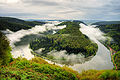
View from the Cloef to the Saar loop

Lookout tower on the Saarschleife treetop path
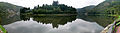
Panorama of the Saar loop at the bank level

The Welles ferry allows a change of the Saar side in the area of the Saar loop


Web links
- Literature about the Saar loop in the Saarland Bibliography
- Saarschleife and the surrounding area. Photo collection by Wolfgang Reichel, Merzig-Besseringen.
- Panorama picture Saarschleife 360 ° panorama picture of the Saarschleife
Individual evidence
- ↑ Ordinance on the nature reserve “Steinbachtal west of Saarschleife” ( memento of the original from March 4, 2016 in the Internet Archive ) Info: The archive link was automatically inserted and not yet checked. Please check the original and archive link according to the instructions and then remove this notice. , accessed April 30, 2012.
- ↑ Herbert Liedtke, Karl-Heinz-Hepp, Christoph Jentsch: The Saarland in map and aerial photo, A contribution to regional studies, ed. from the Land Survey Office of the Saarland, Neumünster 1974, pp. 80–81.
- ↑ Herbert Liedtke, Karl-Heinz-Hepp, Christoph Jentsch: The Saarland in map and aerial photo, A contribution to regional studies, ed. from the Land Survey Office of the Saarland, Neumünster 1974, pp. 80–81.
- ^ Gisela Tascher: The Fuehrer's First Gift - Even before the Gautheater in Saarbrücken, the Nazis were planning an Ordensburg on the Saarschleife, in: Saargeschichten issue 1, 2012, pp. 4-9.
- ↑ Dietmar Klostermann: Hitler's crazy Saarschleife plan, Saarbrücker Zeitung, March 14, 2012.
- ↑ Treetop Walk Saarschleife. Retrieved on September 27, 2016 (operator's website).
Coordinates: 49 ° 30 ′ 4 ″ N , 6 ° 32 ′ 58 ″ E