
Cloef

The Cloef (French la clœf ) is a rocky vantage point at the apex of the Saar loop near Orscholz , a district of Mettlach , where a protruding rock formation made of Taunus quartzite extends down to the Saar and was an obstacle to shipping in earlier times.
There are two theories about the origin of the name Cloef:
- One version derives it from the Latin of CLIVUS or CLEVUS, meaning "slope". This would coincide with the rock formation on which the Cloef refuge stands.
- Another version derives the name from the Celtic, after which it means a "stony kerb valley".
There is also a place called “Clef”, as it is pronounced in the Moselle Franconian dialect, in Luxembourgish . It is the name of the city of Clervaux and Clervaux in Ösling. Similar to the Saar loop, the Clerve river has cut into the mountains, like in a stony, rocky Kerb valley.
The same root also exists on the Lower Rhine with the district town of Kleve (formerly Cleve / Cleef). This is the origin of today's words cliff / cliff. The Schwanenburg in Kleve was built on a rock over an arm of the Old Rhine .
The Cloef viewpoint offers the best view of the Saarschleife , Saarland's landmark, at the foot of Orscholz. Numerous heads of state and politicians visited the lookout point, including the Prussian King Friedrich Wilhelm IV (on September 29, 1856) and Adolf Hitler (on May 16, 1939). The then Saarland Prime Minister Oskar Lafontaine and the later German Chancellor Gerhard Schröder were photographed on August 4, 1997 in front of the striking background. The French President Jacques Chirac and the Polish President Lech Kaczyński met down at the Saarschleife for the three-way summit with Chancellor Angela Merkel on December 5, 2006.

Refuge and viewing terrace
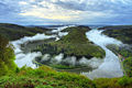
View from the Cloef to the Saar loop
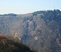
View of the Cloef from Montclair

View from the Cloef to the Saar loop in late summer with the first fog

Visitors on the visitor terrace


Web links
Coordinates: 49 ° 30 ′ 6.8 ″ N , 6 ° 32 ′ 26.7 ″ E