
Sudelfels
The Sudelfels (Sudel: inflected form of sudeln) is located at an altitude of 220 meters above sea level on the Hirnberg on the L354 between the villages of Ihn and Niedaltdorf in Saargau , which are part of the Saarland community of Wallerfangen . It is the site of a Gallo-Roman spring shrine.
geology

The Sudelfelsen is a rock made of limestone tuff . Its formation is due to the leakage of calcareous groundwater at frequently changing places in this area. The rock owes its name to this fact. The Sudelfels is the largest limestone deposit in the Saarland. It is several meters thick and lies on the edge of the Ihner Bach valley.
Mill on the Sudelfelsen

If you follow the concrete path from the Sudelfelsen down, you will find the remains of an oil mill carved into the rock. It was only mentioned and described in the intelligence journal of the Saarlouis district from 1831. It was a two-story building with basement rooms sunk into the rock, a kitchen and two other rooms. In addition, there seems to have been a relatively large population of trees. The water required to operate the mill wheel had to be dammed above the mill. Further information about the mill has not survived. It is likely to be the same mill that the pastor and local history researcher Philipp Schmitt mentioned in 1850.
The fire rider from Sudelfels (legend)
The legend is set in the Thirty Years War :
During the Thirty Years' War a troop of Croatian soldiers on horseback, led by a young ensign, passed the mill on the Sudelfels while fleeing Swedish troops had been defeated by Count Gallas. There they asked the old miller who lived there for bread, bacon and wine. But the miller's wife could only offer you freshly baked bread. The soldiers, however, mocked her and threatened her with death. When the old woman begged for mercy, since she actually had nothing more, the ensign got so angry that he threw one of the loaves of bread at the woman's head and she fell unconscious to the floor. Then the soldiers searched the mill and burned it to the ground with the unconscious miller in it. Then the soldiers moved on and devastated the settlements of Him and Sermlingen. At Tromborn, however, the soldiers were ambushed by displaced peasants and all were killed. Since then, the young ensign has been condemned to ride along the river with a torch on some nights. It is said that if the fire rider is seen, the land is threatened with hardship and danger.
It cannot be proven whether the mill described in the legend was a forerunner of the mill mentioned in 1831 and 1850. However, the saga contains some historically proven facts. Thus, after fighting with the fleeing French troops and their Swedish allies, the imperial troops managed to cross the Saar under the leadership of the aforementioned Count Gallas near Dillingen. The French and Swedish troops fled to the fortified city of Wallerfangen, which was captured by Count Gallas after heavy fighting. Remnants of the French and Swedish troops fled via the Saargau after the conquest. The imperial troops commanded by Gallas actually included Croatian cavalry , who served as mercenaries in the army. As a result of the fighting and looting, the area around Catfish was devastated. The area around Wallerfangen lost around 70% of its population by the end of the war. In 1650 the community of Leidingen, a neighboring community of him, only had 6 households.
Gallo-Roman spring sanctuary
The pastor and local researcher Philipp Schmitt described the current site as early as 1850. He noticed Roman roof tiles and shards of red clay in the garden, the mill then in existence there. Remnants of the wall were found during construction work on a water pipe in 1903. The Provincial Museum in Trier, which was responsible at the time, had an excavation carried out. During this excavation, the floor plans of two temples and parts of a wall were uncovered. After a while, however, the excavation site was covered with soil again. Only between 1981 and 1984 were systematic excavations for scientific research under the direction of Dr. Hermann Maisant instead. Parts of the facility were subsequently reconstructed.
The attachment
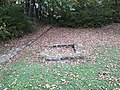
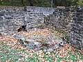
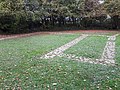
The center of the complex is a small temple area that is separated from the rest of the complex by a wall to the north, south and west. It comprises a total of four adjacent buildings. In the north a small square building, then a rectangular building and an octagonal building and in the south the fountain ( nymphaeum ) with a hexagonal border and a basin consisting of a sandstone block. On the walls of the fountain were pillars that supported a roof. The area in front of the buildings was partly covered with panels. Since the small, square building only has an interior space of 1 m 2 , it is assumed that there was a statue here. The walls of the octagonal structure next to the fountain supported pillars with a roof. In front of this building, in its original position, there is a cube made of lime sinter on a foundation. It is assumed that spring water was drained under the foundation. The water was led via a wooden pipe under the basin of the well, from where it exited through a hole up into the basin.
Square construction

Rectangular construction

Octagonal structure and cuboid made of lime sinter


In the south of the temple complex the remains of an estate ( villa rustica ) with a cold bath ( frigidarium ) were uncovered. The building had a heating system ( hypocaust ) with which the floor and walls could be heated. The bath was drained to the outside through a pipe. The manor was supplied with water from the spring via a pipe made of stone slabs. In the north of the temple area, the foundation walls of other buildings were excavated. These are farm buildings belonging to the farm. The arrangement of the temple district, the manor and the farm buildings leave no doubt as to their togetherness.

Villa rustica
Hotplate
Farm buildings


The size of the complex indicates that the spring sanctuary must have had supraregional importance.
Dating and useful life of the source sanctuary
The use of the individual areas could be determined on the basis of many coin finds. A first sanctuary, consisting of the fountain, the octagonal temple and probably also the rectangular building, was dated to the early 1st century AD. The manor, the farm buildings and the square temple were added later. An examination of the stone monuments and the fact that the setting up of consecration stones and statues as votive offerings was common during this period revealed that the period of use was between the second half of the second century and the first half of the third century AD. The dendrochronological examination of the wooden pipe that supplied the well with water showed that the wood came from an oak that was felled in 267 AD.
Gods worshiped in the spring sanctuary
Rome used the so-called Interpretatio Romana in its conquered territories . That is, local deities were equated and assimilated to Roman deities. The Romans used this practice to maintain religious peace in the occupied territories. In the Roman occupied Gaul, however, there was also the Celtic counterpart, the so-called Interpretatio Celtica, with which the Celts equated and assimilated Roman deities with their deities. Based on their representation and their attributes, as well as on the basis of the consecration altars, sculptures and inscriptions found on consecration tablets, three goddesses and three gods could be identified who were venerated in the spring sanctuary by Celts and Romans:
- Apollo and the Celtic goddess Sirona, who is equated with him
- Mercury and the equated Celtic goddess Rosmerta
- Minerva
- Jupiter
Finds
During the excavations, a woman's torso of a statue was discovered with a snake wrapped around its arm. This torso has been identified as a representation of the Celtic goddess Sirona. After the find, the fountain was named after her Sirona fountain. The largest group of finds are small finds, which predominantly consist of numerous pieces of jewelry and 700 coins. These were offered to the gods as votive offerings. Most of the coins were found in the temple area. In addition, 30 fragments of statues made of limestone and sandstone, consecration tablets and consecration altars, which were set up as votive offerings, were excavated. It is interesting that the votive inscriptions can only be read on the front, which means that they were against a wall. Votive inscriptions with some of the names of the consecrators have also been preserved in fragments. In most cases, the votive inscriptions first name the god or goddess invoked. Then the name of the consecrator is mentioned. They end with the Latin formula VSLM ( votum solvit libens merito: he / she gladly honored the vow gratefully ). The following names of consecrators have been preserved:
- Messor (additional information that he was a libertus , i.e. a released slave )
- Lucius Geminius Similis (additional information that he was a doctor)
- Gi. . .mius Rufinus
- Silvinius Adiuto
- Silvinius Junianus
The finds are in the State Collection of Antiquities at the State Monuments Office in Landsweiler-Reden , in the Museum of Prehistory and Early History in Saarbrücken , in the District Home Museum Dillingen - Leases and in the Historical Museum Wallerfangen .
Franconian graves
During the excavations, two graves were also uncovered in front of the entrance to the manor. The execution of the graves and the finds in the graves made it possible to identify them as Franconian graves. Anthropological research showed that one of the skeletons was a man between 50 and 70 years old.
literature
- Wolfgang Adler , Gerd Weisgerber : Catfish catch. In: Reallexikon der Germanischen Altertumskunde (RGA). 2nd Edition. Volume 33, Walter de Gruyter, Berlin / New York 2006, ISBN 3-11-018388-9 , pp. 143-149.
Web links
Individual evidence
- ↑ a b c Isabelle Jost: The source sanctuary Sudelfels in Him . In: iflis.de (Institute for Regional Studies in Saarland), accessed on October 22, 2018.
- ↑ a b c d Barbara Ames-Adler: The source sanctuary Sudelfels . Saarlouis district. Archived from the original on October 25, 2018. Retrieved December 1, 2019.
- ^ Aloys Lehnert: History of the city of Dillingen / Saar, Dillingen . Published by the city administration of Dillingen, 1978.
- ^ Anton Jakob: The Thirty Years' War and its consequences for the lower Saargau . 3rd yearbook of the Association for Local Lore in the Merzig District, Merzig 1934.
- ↑ Traces of the past - Leidingen (2) . In: Verein-fuer-Heimatforschung-Wallerfangen.de , accessed on October 22, 2018.
- ↑ a b c d e Barbara Ames-Adler: Him - Sudelfels: A spring sanctuary from Roman times . In: Kreis-saarlouis.de , Tourismusverband Landkreis Saarlouis, accessed on October 22, 2018 (PDF).
- ^ Johann Figl (Ed.): Handbuch Religionswissenschaft: Religionen and their central themes . Tyrolia Verlag, Vienna 2017, ISBN 9783702236144 .
Coordinates: 49 ° 20 ′ 9.7 ″ N , 6 ° 36 ′ 24 ″ E