Upper hatches
|
Upper hatches
Perl parish
|
||
|---|---|---|
| Coordinates: 49 ° 30 ′ 22 ″ N , 6 ° 28 ′ 9 ″ E | ||
| Height : | 353 m | |
| Area : | 7.14 km² | |
| Residents : | 543 (Jul 1, 2014) | |
| Population density : | 76 inhabitants / km² | |
| Incorporation : | 1st January 1974 | |
| Postal code : | 66706 | |
| Area code : | 06865 | |
|
Location of Oberleuken in Saarland |
||
|
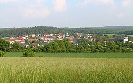
View from the north to Oberleuken
|
||
Oberleuken is a district of the municipality of Perl in the Merzig-Wadern district ( Saarland ). Together with Keßlingen and Münzingen , the district forms a municipality. Until the end of 1973 Oberleuken was an independent municipality.
geography
Oberleuken lies in a valley on both sides of the Leukbach , which rises in Eft , five kilometers above Oberleuken. The village is located on one of the oldest settlement areas in the area, as shown by the antiquities excavated and found in the area ( axes , hand axes , remains of bowls, pots and bowls). Building foundations and archaeological remains of a Roman settlement ( Villa Borg ) were discovered in the southeastern part of the community forest of the neighboring village of Borg .
history
The first documented information about Oberleuken comes from the year 964. In a so-called precarious contract (land loan contract), Gaugraf Siegfried gave Trier Archbishop Heinrich I 73 acres of land (fields and meadows) and 7 servants (subjects) to “Odowines luica “(Oberleuken) in Saargau . Later Oberleuken is only called "luca" (1126) and "Luke" (1255) and only in 1533 is called "Oberleuken".
In the Middle Ages , the Leukbach was once a border river. The inhabitants on the left of the Leuk belonged to the Electorate of Trier and those on the right of the Leuk to the Duchy of Lorraine .
When the Duchy of Lorraine was dissolved in 1766, all previous Lorraine towns, including the part of Oberleuken to the right of the Leuk, came to France . In 1797 the whole Saargau was united with France.
At the Congress of Vienna in 1815, the lower Saar area was awarded to Prussia . But it wasn't until 1830 that the border from Perl to the west of Merzig was finally determined. The year 1830 can still be read on an old boundary stone.
As part of the regional and administrative reform in Saarland , the previously independent municipality of Oberleuken was assigned to the new municipality of Perl on January 1, 1974 .
Population development
The development of the population of Oberleuken, the values from 1939 to 1974 are based on censuses:
| year | Residents |
|---|---|
| 1939 | 495 |
| 1950 | 441 |
| 1961 | 446 |
| 1970 | 469 |
| 1974 | 454 |
| 2004 | 524 |
| 2010 | 544 |
| 2012 | 517 |
| 2013 | 533 |
| 2014 | 543 |
| 2020 | 571 |
literature
- Ernst Wackenroder : The art monuments of the Saarburg district . (= Paul Clemen (Hrsg.): Die Kunstdenkmäler der Rheinprovinz , Volume 15, III. Department). L. Schwann, Düsseldorf 1939 (reprint from the Academic Bookshop Interbook, Trier 1982), pp. 154–155.
Web links
- Homepage of Oberleuken
- Oberleuken district on the Perl website
- Literature about Oberleuken in the Saarland Bibliography
Individual evidence
- ↑ a b Statistical overview of the municipality of Perl on www.perl-mosel.de
- ^ Federal Statistical Office (ed.): Historical municipality directory for the Federal Republic of Germany. Name, border and key number changes in municipalities, counties and administrative districts from May 27, 1970 to December 31, 1982 . W. Kohlhammer, Stuttgart / Mainz 1983, ISBN 3-17-003263-1 , p. 804 .


