Leukbach
| Leukbach | ||
|
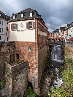
Waterfall of the Leuk |
||
| Data | ||
| Water code | DE : 26496 | |
| location | Germany | |
| River system | Rhine | |
| Drain over | Saar → Moselle → Rhine → North Sea | |
| source | in Eft , district Eft-Hellendorf, municipality Perl 49 ° 28 ′ 38 ″ N , 6 ° 26 ′ 43 ″ E |
|
| Source height | approx. 365 m above sea level NN | |
| muzzle | in Saarburg in the Saar coordinates: 49 ° 36 '28 " N , 6 ° 33' 13" E 49 ° 36 '28 " N , 6 ° 33' 13" E |
|
| Mouth height | approx. 145 m above sea level NN | |
| Height difference | approx. 220 m | |
| Bottom slope | approx. 15 ‰ | |
| length | 15 km | |
| Catchment area | 87.9 km² | |
| Discharge at the Saarburg gauge 2 A Eo : 76 km² Location: 1.2 km above the mouth |
NNQ (23.09.1974) MNQ 1963/2007 MQ 1963/2007 Mq 1963/2007 MHQ 1963/2007 HHQ (23.01.1995) |
57 l / s 223 l / s 806 l / s 10.6 l / (s km²) 17.7 m³ / s 59.5 m³ / s |
The Leukbach (or the Leuk ) is a left tributary of the Saar and has a length of 15 km. The catchment area is 87.9 km². It is a second order body of water from the mouth in Saarburg to the Saarland border near Freudenburg .
geography
course
The Leukbach rises in Eft , district Eft-Hellendorf, municipality of Perl in Saarland and flows through the municipalities of Mettlach , Kollesleuken (Freudenburg), Trassem and flows into the Saar in Saarburg ( Rhineland-Palatinate ).
The Leukbach was diverted near Saarburg in the 12th century and has since plunged over an 18 m high waterfall . This makes it practically inaccessible to fish and other aquatic fauna from the Saar.
Tributaries
- Hellendorfbach ( right )
- Schuhbour ( right )
- Hundelsbach ( right )
- Galgenbach ( left )
- Fischerbach ( left )
- Oberleukner Klingelbach ( left )
- Gliederbach ( left ), 4.0 km
- Merlbach ( right )
- Dinscheidbach ( right )
- Ortungsbach ( right )
- Gehansbach ( right )
- Endinger Bach ( right )
- Schenkelbach ( right ), 0.6 km
- Ebertsbach ( right ), 1.2 km
- Perbesbach ( left )
- Ehlgraben ( left )
- Freudenburger Bach ( right ), 2.7 km
- Kirfer Bach ( left ), 1.6 miles
- Meuricher Bach ( Weyerbach ) ( left ), 2.5 km
- Schondbach ( left )
- Muschbach ( right )
- Sprenkelbach ( left ), 3.2 km
- Zinnbach ( left )
- Kreuzbach ( right )
- Mandelbach ( left )
- Lohbach ( left ), 3.3 km
Individual evidence
Web links
Commons : Leukbach - Collection of images, videos and audio files
