
Kirf
| coat of arms | Germany map | |
|---|---|---|

|
Coordinates: 49 ° 33 ' N , 6 ° 29' E |
|
| Basic data | ||
| State : | Rhineland-Palatinate | |
| County : | Trier-Saarburg | |
| Association municipality : | Saarburg-Kell | |
| Height : | 320 m above sea level NHN | |
| Area : | 19.14 km 2 | |
| Residents: | 804 (Dec. 31, 2019) | |
| Population density : | 42 inhabitants per km 2 | |
| Postal code : | 54441 | |
| Primaries : | 06582, 06583 | |
| License plate : | TR, SAB | |
| Community key : | 07 2 35 062 | |
| Community structure: | 3 districts | |
| Association administration address: | Schloßberg 6 54439 Saarburg |
|
| Website : | ||
| Local Mayor : | Reinhold Anton (FWG) | |
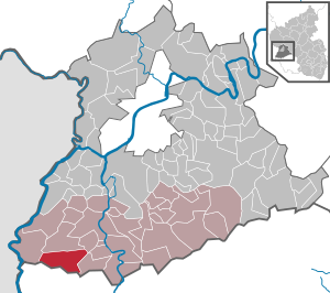
| Location of the local community Kirf in the district of Trier-Saarburg | ||
  |
||


Kirf is a municipality in the Trier-Saarburg district in Rhineland-Palatinate . It belongs to the Saarburg-Kell association.
Community structure
The local community Kirf consists of the eponymous capital and the districts of Beuren / Saargau and Meurich. Both districts are local districts . The residential areas Hof Breitenacker and Hof Spirkelsbach also belong to the Kirf district ; Beuren includes the hamlet of Breinsdorf and the Kampholzer Hof and Waldhof residential areas; Meurich includes the Oberste and Unterste Neumühle as well as the Weyerhäuschen and “In den Dreimorgen” residential areas.
history
The place was settled early, as evidenced by stone age equipment finds and Roman building remains in the area. Since the middle of the 5th century, a Franconian cemetery has been occupied in the area around today's church. This carries the Remigius - patronage , suggesting a church founded in the 7th century. The place appears as Kirchfa in 1222 in the list of places on pilgrimage to Mettlach in the 10th century . The place name is derived from the Franconian Vach, weir for fishing.
Medieval and modern local history shows church, state and manorial rights fragmented. Kirf was with a Beuren kurtrierisch - Lorraine Kondominat , parts of the village were also among Luxembourg dominions. According to the Trier fire book , there were 21 fireplaces or families in Kirf in 1563; in 1684 only eleven were counted.
The area was conquered during the First Coalition War and came under French administration in 1798. After the Congress of Vienna , the Kingdom of Prussia came into being in 1815 .
On July 18, 1946, Kirf, together with 80 other communities in the districts of Trier and Saarburg , was annexed to the Saar area , which was separated from the rest of the French occupation zone in February 1946 and which was no longer subject to the Allied Control Council at the time . On June 6, 1947, this territorial outsourcing was withdrawn to 21 communities, so Kirf came to the 1946 newly formed state of Rhineland-Palatinate .
On June 7, 1969, part of the community with 101 residents was re-congregated to Freudenburg . The two previously independent communities Beuren (Saargau) (205 inhabitants at the time) and Meurich (201 inhabitants) were incorporated on March 17, 1974.
- Population development
The development of the population of Kirf in relation to today's municipality area; the values from 1871 to 1987 are based on censuses:
|
|
politics
Municipal council
The local council in Kirf consists of twelve council members, who were elected in a personalized proportional representation in the local elections on May 26, 2019 , and the honorary local mayor as chairman.
The distribution of seats in the local council:
| choice | CDU | Flat share 1 | Flat share 2 | Flat share 3 | FWG | total |
|---|---|---|---|---|---|---|
| 2019 | 3 | 2 | 2 | - | 5 | 12 seats |
| 2014 | 4th | 2 | 2 | - | 4th | 12 seats |
| 2009 | 5 | 4th | 2 | 1 | - | 12 seats |
| 2004 | 5 | 3 | 2 | 2 | - | 12 seats |
- FWG = Free Voting Group Local Community Kirf e. V.
Districts
The two local districts of Beuren and Meurich have directly elected mayors , but no local councils .
coat of arms
|
|
Blazon : "In blue a silver curved tip , inside a continuous red bar cross , in front a golden double cross, behind four silver bars ." |
| Foundation of the coat of arms: Before 1800, Kirf belonged to three different manors. Most of the community belonged to Kurtrier , which is indicated by the Electoral Trier cross at the top; another part was Lorraine , hence the Lorraine double cross in front; a small part belonged to Luxembourg , represented by the basic colors of the former Luxembourg coat of arms, divided by silver and blue (nine times today). |
Attractions
The townscape of Kirf is characterized by the Catholic parish church of St. Remigius and the opposite war memorial for the fallen soldiers of the First World War .
See also: List of cultural monuments in Kirf
Personalities
- Maria Croon (1891–1983), writer
- Otto Theisen (1924-2005), lawyer and politician (CDU)
literature
- Ernst Wackenroder : The art monuments of the Saarburg district . (= Paul Clemen (Hrsg.): Die Kunstdenkmäler der Rheinprovinz , Volume 15, III. Department). L. Schwann, Düsseldorf 1939 (reprint from the Academic Bookshop Interbook, Trier 1982), pp. 126–127.
Web links
- Local community Kirf on the website of the Saarburg-Kell association
- To search for cultural assets of the local community Kirf in the database of cultural assets in the Trier region .
- Link catalog on Kirf at curlie.org (formerly DMOZ )
Individual evidence
- ↑ State Statistical Office of Rhineland-Palatinate - population status 2019, districts, communities, association communities ( help on this ).
- ↑ State Statistical Office Rhineland-Palatinate (ed.): Official directory of the municipalities and parts of the municipality. Status: January 2019 [ Version 2020 is available. ] . S. 124 (PDF; 3 MB).
- ↑ Local community Kirf on region-trier.de
- ^ Wilhelm Fabricius : Explanations for the Historical Atlas of the Rhine Province. The map from 1789 (2nd volume), Bonn 1898, p. 149.
- ↑ a b Official municipality directory 2006 ( Memento from December 22, 2017 in the Internet Archive ) (= State Statistical Office Rhineland-Palatinate [Hrsg.]: Statistical volumes . Volume 393 ). Bad Ems March 2006, p. 176, 182 (PDF; 2.6 MB). Info: An up-to-date directory ( 2016 ) is available, but in the section "Territorial changes - Territorial administrative reform" it does not give any population figures.
- ↑ State Statistical Office Rhineland-Palatinate: My village, my city. Retrieved July 17, 2019 .
- ^ The Regional Returning Officer Rhineland-Palatinate: Local elections 2019, city and municipal council elections

Aach | Ayl | Baldringen | Bekond | Notification | Beuren (high forest) | Bonerath | Damflos | Detzem | Ensch | Farschweiler | Fur | Fish | Pine | Franzenheim | Freudenburg | Geisfeld | Greimerath | Grimburg | Gusenburg | Gusterath | Gutweiler | Heddert | Stalling | Herl | Hermeskeil | Hinzenburg | Hinzert-Pölert | Hockweiler | Holzerath | Hedgehog | Irsch | Kanzem | Chasuble | Kastel-Staadt | Kell am See | Kenn | Kirf | Klüsserath | Conc | Cord | Korlingen | Köwerich | Lampades | Langsur | Leiwen | Lunge | Longuich | Lorscheid | Mandern | Mannebach | Mehring | Mertesdorf | Merzkirchen | Morscheid | Naurath (Eifel) | Naurath (forest) | Neuhütten | Newel | Nittel | Upper cheap | Ockfen | Ollmuth | Onsdorf | Osburg | Palzem | Paschel | Pellingen | Pluwig | Pölich | Ralingen | Swift oath | Reinsfeld | Riol | Riveris | Saarburg | Schillings | Schleich | Schoden | Schömerich | Schondorf | Schweich | Serrig | Sommerau | Taben-Rodt | Tawern | Temmels | Thomm | Thörnich | Trassem | Trierweiler | Trittenheim | Vierherrenborn | Waldrach | Waldweiler | Wasserliesch | Wawern | Waves | Welschbillig | Wiltingen | Wincheringen | Zemmer | Zerf | Züsch