
Bad Kreuznach district
| coat of arms | Germany map |
|---|---|

|

Coordinates: 49 ° 49 ' N , 7 ° 41' E |
| Basic data | |
| State : | Rhineland-Palatinate |
| Administrative headquarters : | Bad Kreuznach |
| Area : | 863.76 km 2 |
| Residents: | 158,345 (Dec. 31, 2019) |
| Population density : | 183 inhabitants per km 2 |
| License plate : | KH |
| Circle key : | 07 1 33 |
| NUTS : | DEB14 |
| Circle structure: | 118 parishes |
| Address of the district administration: |
Salinenstrasse 47 55543 Bad Kreuznach |
| Website : | |
| District Administrator : | Bettina Dickes ( CDU ) |
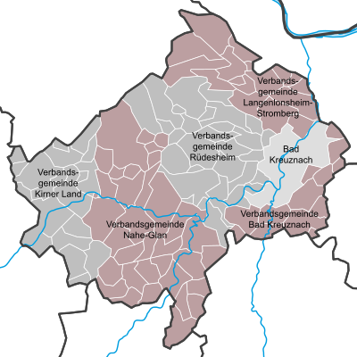
| Location of the Bad Kreuznach district in Rhineland-Palatinate | |
  |
|
The Bad Kreuznach district is a regional authority in the center of Rhineland-Palatinate . The seat of the district administration and at the same time the most populous municipality is the city of the same name, Bad Kreuznach .
geography
location
The Bad Kreuznach district comprises parts of the Rheinhessen table and hill country in the east, the northern Palatinate mountain region in the south and the Hunsrück in the west and north . The main axis in the district is the Nahe , which flows from the west through Kirn , Bad Sobernheim and Bad Kreuznach and leaves the district in the north. The Bad Kreuznach district, together with parts of the Mainz-Bingen district and the Donnersberg district, form the Nahe wine-growing region .
Neighboring areas
The district borders in a clockwise direction in the northeast with the districts of Mainz-Bingen , Alzey-Worms , Donnersbergkreis , Kusel , Birkenfeld and Rhein-Hunsrück-Kreis .
history
Until the end of the 18th century, the area of today's Bad Kreuznach district was divided into various smaller and larger territories .
In 1794 the Left Bank of the Rhine was occupied during the First Coalition War , and in 1798 the area was reorganized by the French directorate based on the French model. The area of the later district of Kreuznach was divided into the Rhine-Moselle department and the Saar department until 1814 . After the end of French rule in the area on the left bank of the Rhine (1814), the region was assigned to the Kingdom of Prussia at the Congress of Vienna (1815) . Under the Prussian administration, the Kreuznach district in the Koblenz administrative district was re-established in 1816 and had belonged to the Rhine province since 1822 .
In 1932 the Kreuznach district was merged with the Meisenheim district. As part of the first step of the district reform in Rhineland-Palatinate , the district was redesigned on June 7, 1969 and renamed the Bad Kreuznach district . New arrivals to the county
- the local communities Frei-Laubersheim , Fürfeld , Neu-Bamberg and Tiefenthal from the dissolved Alzey district
- the local communities Biebelsheim , Bosenheim , Hackenheim , Ippesheim , Pfaffen-Schwabenheim , Planig , Pleitersheim and Volxheim from the dissolved district of Bingen
- the local community Kirnsulzbach from the Birkenfeld district
- the local communities Becherbach , Gangloff , Reiffelbach , Roth and Schmittweiler from the Kusel district as well
- the local communities Altenbamberg , Callbach , Duchroth , Ebernburg , Feilbingert , Hallgarten , Hochstätten , Lettweiler , Oberhausen an der Nahe , Odernheim am Glan and Rehborn from the dissolved district of Rockenhausen .
At the same time, the district gave the local communities of Bingerbrück , Münster-Sarmsheim , Waldalgesheim and Weiler bei Bingerbrück to the new district of Mainz-Bingen and the local communities of Hoppstädten and Medard to the district of Kusel.
In the second step of the district reform, the district took on the local communities Bruschied , Kellenbach , Königsau , Schneppenbach and Schwarzerden from the Rhein-Hunsrück district on November 7, 1970 and ceded the local community Genheim to the Mainz-Bingen district.
Population statistics

|
|
Denomination statistics
According to the 2011 census , in 2011 the majority of the population was 43.8% Protestant , 32.2% Roman Catholic and 24.0% were non-denominational , belonged to another religious community or did not provide any information. The number of Protestants and Catholics has fallen since then. Currently (as of March 31, 2020) 38.0% are Protestant, 29.0% of the population are Roman Catholic and 33.0% either belong to another religion or are non-denominational.
politics
district council of the Bad Kreuznach district 2019
- Left : 2
- Greens : 7
- SPD : 12
- FREE VOTERS : 2
- FWG district : 3
- FDP : 3
- CDU : 16
- AfD : 5
District council

The district council of the Bad Kreuznach district consists of 50 elected members and the district administrator as chairman. The district election on May 26, 2019 led to the following election result:
| Parties and constituencies |
% 2019 |
Seats 2019 |
% 2014 |
Seats 2014 |
% 2009 |
Seats 2009 |
|
| CDU | Christian Democratic Union of Germany | 31.4 | 16 | 37.4 | 19th | 37.0 | 19th |
| SPD | Social Democratic Party of Germany | 25.1 | 12 | 34.5 | 17th | 32.9 | 16 |
| GREEN | Alliance 90 / The Greens | 15.0 | 7th | 8.1 | 4th | 8.0 | 4th |
| AfD | Alternative for Germany | 9.6 | 5 | 5.2 | 3 | - | - |
| FDP | Free Democratic Party | 6.8 | 3 | 4.4 | 2 | 9.9 | 5 |
| FWG circle | Free group of voters in the Bad Kreuznach district | 5.2 | 3 | 7.0 | 3 | 8.8 | 4th |
| THE LEFT. | THE LEFT. | 3.7 | 2 | 3.5 | 2 | 3.4 | 2 |
| FREE VOTERS | FREE VOTERS | 3.3 | 2 | - | - | - | - |
| total | 100.0 | 50 | 100.0 | 50 | 100.0 | 50 | |
| Voter turnout in% | 61.1 | 57.5 | 55.3 | ||||
District administrators
The district administrator is directly elected for eight years. In the April 2017 election, Bettina Dickes (CDU) prevailed.
- 1816-1818 Damian Bitter
- 1818–1846 Ludwig Philipp Hout (1775–1846)
- 1846–1861 Gustav von Jagow (1813–1879)
- 1861–1902 Otto Agricola (1829–1902)
- 1903–1920 Erwin von Nasse
- 1920–1933 Erich Müser (1882–1944), expelled 1923–1924
- 1923–1924 Otto Ehrensberger (1887–1968), acting
- 1933 Ernst Schmitt (1896–1972)
- 1933–1936 Hellmuth Rademacher (1900–1984)
- 1936–1940 Nikolaus Simmer (1902–1986)
- 1940–1945 Konrad Noell (1904–1965)
- 1945 Philipp Palm
- 1945–1946 Fritz Sieben (1883–1966)
- 1946–1967 Philipp Graeff
- 1967–1990 Hans Schumm (1927–2007)
- 1990–1991 Walter Zuber (1943–2014), SPD
- 1991–2009 Karl-Otto Velten (* 1949), SPD
- 2009–2017 Franz-Josef Diel (* 1949), CDU
- 2017–2025 Bettina Dickes (* 1971), CDU
Bettina Dickes took up her position on July 7, 2017. In the runoff election on April 2, 2017, she prevailed against Hans-Dirk Nies (SPD) with a share of 58.7% of the vote, after none of the original four applicants had achieved a sufficient majority in the direct election on March 19, 2017.
badges and flags
Hoist flag

Banner flag

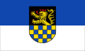
The Bad Kreuznach district has a coat of arms as well as a hoist and banner flag .
|
|
Blazon : "Divided: the top of a growing black, red crowned and reinforced golden lion, down in four rows geschacht of blue and gold."
The coat of arms was approved on September 13, 1939. |
| Justification of the coat of arms: The lion symbolizes the former parts of the Electoral Palatinate, the lower part of the shield the possessions of the Vordere Grafschaft Sponheim. |
Partnerships
-
 Tempelhof-Schöneberg District , Berlin , Germany (since 1963)
 -
 Kirjat Motzkin , Israel (since 1969)
 -
 Szczytno , Poland (since 1993)
Economy and Infrastructure
The district is characterized by agriculture (wine, wheat, rape, barley, maize and cattle breeding). Only in the east around Bad Kreuznach is there a denser concentration of medium-sized companies, especially in production and logistics. In addition to mechanical engineering and the manufacture of spare parts, the wine industry, in particular bottling and cellar technology, is important. Tourism is also playing an increasingly important role in the marketing of the Nahe wine, the spa towns of Bad Kreuznach and Bad Münster am Stein-Ebernburg, parts of the North Palatinate Uplands and the Hunsrück.
In the Future Atlas 2016 , the Bad Kreuznach district was ranked 226 out of 402 districts, municipal associations and urban districts in Germany, making it one of the regions with a “balanced risk-opportunity mix” for the future.
traffic
In the east of the Bad Kreuznach district, the federal motorway 61 (Ludwigshafen – Koblenz) touches the district area. The federal highways 41 , 48 , 421 and 428 also run through the district. The B 420 runs along the very southern edge .
cities and communes
(in brackets the number of inhabitants as of December 31, 2019)
| Association-free city |
|

Association municipalities with their association members:
The following municipalities in the district have lost their independence to this day:
- Wald-Erbach was incorporated into the Warmsroth community in 1920.
- Münster near Bingerbrück and Sarmsheim were merged on October 1, 1928 to form the municipality of Münster-Sarmsheim .
- On June 7, 1969, Bad Münster am Stein merged with the community of Ebernburg to form the community of Bad Münster am Stein-Ebernburg .
- Dhaun , Hochstädten and Hochstetten b. Kirn were merged on June 7, 1969 to form the municipality of Hochstetten-Dhaun .
- Heddesheim (Nahe) and Waldhilbersheim were merged on June 7, 1969 to form the community of Guldental .
- Heimberg and Krebsweiler merged on June 7, 1969 to form the community of Heimweiler .
- Kallenfels was incorporated into the city of Kirn on June 7, 1969.
- Winzenheim was incorporated into the city of Bad Kreuznach on June 7, 1969.
- Eckweiler and Pferdefeld were incorporated into the town of Bad Sobernheim on June 10, 1979.
- The city of Bad Münster am Stein-Ebernburg was incorporated into the city of Bad Kreuznach on July 1, 2014.
License Plate
On July 1, 1956, the district was assigned the distinctive sign KH when the vehicle registration number that is still valid today (at that time still the Kreuznach district ) was assigned. It is still issued today.
Web links
- Website of the Bad Kreuznach district
- Statistical data for the Bad Kreuznach district from the Rhineland-Palatinate State Statistical Office
- Literature from and about the Bad Kreuznach district in the catalog of the German National Library
- Literature on the Bad Kreuznach district in the Rhineland-Palatinate state bibliography
Individual evidence
- ↑ State Statistical Office of Rhineland-Palatinate - population status 2019, districts, communities, association communities ( help on this ).
- ↑ Official municipality directory 2006 ( Memento from December 22, 2017 in the Internet Archive ) (= State Statistical Office Rhineland-Palatinate [Hrsg.]: Statistical volumes . Volume 393 ). Bad Ems March 2006, p. 159 (PDF; 2.6 MB). Info: An up-to-date directory ( 2016 ) is available, but in the section "Territorial changes - Territorial administrative reform" it does not give any population figures.
- ^ Contributions to the statistics of the Königl. Prussian Rhineland. 1829, p. 20 , accessed November 11, 2017 .
- ^ The Rhine Province under Prussia, Willemsen, 1842
- ↑ a b Community encyclopedia for the Kingdom of Prussia 1885
- ↑ a b c d e f Michael Rademacher: German administrative history from the unification of the empire in 1871 to the reunification in 1990. kreuznach.html. (Online material for the dissertation, Osnabrück 2006).
- ↑ Statistical Yearbook for the Federal Republic of Germany 1972
- ↑ Statistical Yearbook for the Federal Republic of Germany 1981
- ↑ Statistical Yearbook for the Federal Republic of Germany 1992
- ↑ Statistical Yearbook for the Federal Republic of Germany 2002
- ↑ Landkreis Bad Kreuznach Religion , 2011 census
- ↑ Rhineland-Palatinate municipal statistics for the Bad Kreuznach district , accessed on May 7, 2020
- ^ The regional returning officer RLP: Bad Kreuznach district. Final result of the 2019 district council election. Accessed August 10, 2019 .
- ^ Stefan Munzlinger: District election in Bad Kreuznach: landslide victory for Bettina Dickes, debacle for Nies. Rhein-Zeitung - Oeffentlicher Anzeiger, April 3, 2017, accessed on December 1, 2019 .
- ↑ Future Atlas 2016. (No longer available online.) Archived from the original on October 2, 2017 ; accessed on March 23, 2018 . Info: The archive link was inserted automatically and has not yet been checked. Please check the original and archive link according to the instructions and then remove this notice.
- ↑ State Statistical Office of Rhineland-Palatinate - population status 2019, districts, communities, association communities ( help on this ).
Districts:
Ahrweiler |
Altenkirchen (Westerwald) |
Alzey-Worms |
Bad Dürkheim |
Bad Kreuznach |
Bernkastel-Wittlich |
Birkenfeld |
Cochem cell |
Donnersbergkreis |
Eifelkreis Bitburg-Prüm |
Germersheim |
Kaiserslautern |
Kusel |
Mainz-Bingen |
Mayen-Koblenz |
Neuwied |
Rhine-Hunsrück District |
Rhein-Lahn district |
Rhine-Palatinate District |
Southern Wine Route |
Southwest Palatinate |
Trier-Saarburg |
Vulkaneifel |
Westerwaldkreis
Independent cities:
Frankenthal (Pfalz) |
Kaiserslautern |
Koblenz |
Landau in the Palatinate |
Ludwigshafen am Rhein |
Mainz |
Neustadt an der Weinstrasse |
Pirmasens |
Speyer |
Trier |
Worms |
Zweibrücken