
Desloch
| coat of arms | Germany map | |
|---|---|---|

|
Coordinates: 49 ° 43 ' N , 7 ° 38' E |
|
| Basic data | ||
| State : | Rhineland-Palatinate | |
| County : | Bad Kreuznach | |
| Association municipality : | Nahe-Glan | |
| Height : | 285 m above sea level NHN | |
| Area : | 6.37 km 2 | |
| Residents: | 326 (Dec. 31, 2019) | |
| Population density : | 51 inhabitants per km 2 | |
| Postal code : | 55592 | |
| Area code : | 06753 | |
| License plate : | KH | |
| Community key : | 07 1 33 024 | |
| LOCODE : | DE D9H | |
| Association administration address: | Obertor 13 55590 Meisenheim, Germany |
|
| Website : | ||
| Local Mayor : | Udo Reidenbach | |
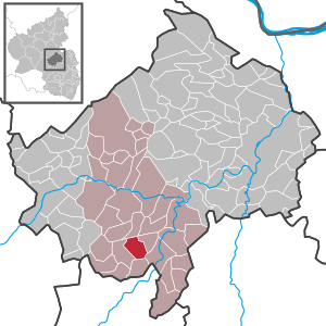
| Location of the local community Desloch in the Bad Kreuznach district | ||
  |
||

Desloch is a municipality in the Bad Kreuznach district in Rhineland-Palatinate . It belongs to the community of Nahe-Glan .
geography
The street village is located three kilometers northwest of Meisenheim am Glan on the northern edge of the North Palatinate highlands . To the south, Breitenheim , southwest Jeckenbach , in the north Lauschied and northeast is Raumbach .
The Neuwieser Hof residential area also belongs to Desloch .
history
Desloch was first mentioned in a document in 1184. From 1815 to 1866 it belonged to the Oberamt Meisenheim of the Landgraviate of Hessen-Homburg and came with this to Prussia in 1866 .
- Statistics on population development
The development of the population of Desloch, the values from 1871 to 1987 are based on censuses:
|
|
politics
Municipal council
The council in Desloch consists of eight council members, who in the local elections on May 26, 2019 in a majority vote were elected, and the honorary mayor as chairman.
mayor
Local mayor is Udo Reidenbach. In the local elections on May 26, 2019, he was confirmed in his office with a share of 69.82% of the votes.
coat of arms
|
|
Blazon : “Split of black and gold over a mountain of three in exchanged colors, inside a black star in front and a golden five-pointed star in the back. Above are two lions facing each other, holding a five-pointed star in the middle in reversed colors. In front the lion gold, red armored and crowned, behind the lion red, blue armored and crowned. " |
| Reasons for the coat of arms: The red lion reminds of the former affiliation to the Wild- and Rheingrafen , the golden lion to the Pfalz-Zweibrücken . |
traffic
The federal highway 420 runs to the east . In Staudernheim there is a train station of the Nahe Valley Railway .
See also
Web links
- Homepage of the local community Desloch
- Private website about Desloch
- Literature about Desloch in the Rhineland-Palatinate State Bibliography
Individual evidence
- ↑ State Statistical Office of Rhineland-Palatinate - population status 2019, districts, communities, association communities ( help on this ).
- ↑ State Statistical Office Rhineland-Palatinate (ed.): Official directory of the municipalities and parts of the municipality. Status: January 2019 [ Version 2020 is available. ] . S. 23 (PDF; 3 MB).
- ↑ State Statistical Office Rhineland-Palatinate: My village, my city. Retrieved October 19, 2019 .
- ^ The Regional Returning Officer RLP: City Council Election 2019 Desloch. Retrieved September 26, 2019 .
- ^ The Regional Returning Officer RLP: direct elections 2019. see Meisenheim, Verbandsgemeinde, fifth row of results. Retrieved September 26, 2019 .

Abtweiler | Allenfeld | Altenbamberg | Eagle swings | Floodplains | Bad Kreuznach | Bad Sobernheim | Bärenbach | Bärweiler | Becherbach | Becherbach near Kirn | Biebelsheim | Bockenau | Boos | Braunweiler | Brauweiler | Breitenheim | Bretzenheim | Bruschied | Burgsponheim | Callbach | Dalberg | Daubach | Daxweiler | Desloch | Dörrebach | Dorsheim | Duchroth | Eckenroth | Feilbingert | Frei-Laubersheim | Fürfeld | Gebroth | Guldental | Gutenberg | Hackenheim | Hahnenbach | Hallgarten | Hargesheim | Heimweiler | Heinzenberg | Hennweiler | Hergenfeld | Hochstätten | Hochstetten-Dhaun | Horbach | Hüffelsheim | Hundsbach | Ippenschied | Jeckenbach | Kellenbach | Kirn | Cherry red | Königsau | Langenlonsheim | Langenthal | Laubenheim | Listener | Lettweiler | Limbach | Löllbach | Almond | Martinstein | Meckenbach | Meddersheim | Meisenheim | Merxheim | Monzingen | Münchwald | New Bamberg | Niederhausen | Norheim | Walnut | Oberhausen an der Nahe | Oberhausen near Kirn | Oberstreit | Odernheim am Glan | Otzweiler | Pfaffen-Schwabenheim | Pleitersheim | Raumbach | Rehbach | Rehborn | Reiffelbach | Roth | Roxheim | Rudesheim | Rümmelsheim | Saint Catherine | Schloßböckelheim | Schmittweiler | Schneppenbach | Schöneberg | Black earth | Schweinschied | Schweppenhausen | Seesbach | Seibersbach | Simmertal | Summer slump | Spa bridges | Spall | Sponheim | Staudernheim | Stromberg | Tiefenthal | Traisen | Volxheim | Waldböckelheim | Waldlaubersheim | Wallhausen | Warmsroth | Hamlet near Monzingen | Weinsheim | Weitersborn | Windesheim | Winterbach | Winterburg