
Daxweiler
| coat of arms | Germany map | |
|---|---|---|

|
Coordinates: 49 ° 58 ' N , 7 ° 45' E |
|
| Basic data | ||
| State : | Rhineland-Palatinate | |
| County : | Bad Kreuznach | |
| Association municipality : | Langenlonsheim-Stromberg | |
| Height : | 365 m above sea level NHN | |
| Area : | 16.65 km 2 | |
| Residents: | 739 (Dec. 31, 2019) | |
| Population density : | 44 inhabitants per km 2 | |
| Postal code : | 55442 | |
| Primaries : | 06724, 06764 | |
| License plate : | KH | |
| Community key : | 07 1 33 023 | |
| Association administration address: | Warmsrother Grund 2 55442 Stromberg |
|
| Website : | ||
| Local Mayor : | Horst Rienecker | |
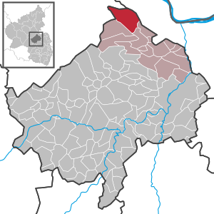
| Location of the local community of Daxweiler in the Bad Kreuznach district | ||
  |
||

Daxweiler is a municipality in the Bad Kreuznach district in Rhineland-Palatinate . It belongs to the Langenlonsheim-Stromberg community .
geography
The community is located in the Soonwald part of the Northern Upper Rhine Lowlands in Rhineland-Palatinate west of the Rhine . Extensive forest sections make up more than 85 percent of the area of Daxweiler. Daxweiler is easy to reach thanks to the close connection to the A 61 .
The residential areas Eichhof , Eichmühle , Forsthaus Emmerichshütte , Forsthaus Tiefenbach , Soonfried and Stromberger Neuhütte , Forsthaus Lauschhütte are located in the municipality .
history
Ritter Werner II. Of Bolanden mentioned the place name Daxweiler ( Dahswilre ) for the first time in his fief directory of 1190. 1419 took over the Palatinate Daxweiler the Elector of Mainz, earlier she had been around 1,375 in mortgage shaft taken. It remained in the possession of the Electoral Palatinate until the French Revolution at the end of the 18th century.
The history of the place is closely connected with the Puricelli family, who owned a company at the Stromberger Neuhütte and the Rheinböller Hütte and thus provided work in the region. Your family coat of arms can therefore also be found in the local coat of arms of Daxweiler.
On January 1, 1969, part of the community of Daxweiler with 70 inhabitants was re-municipalityed to Rheinböllen .
- Statistics on population development
The development of the population of Daxweiler in relation to today's municipal area; the values from 1871 to 1987 are based on censuses:
|
|
politics
Municipal council
The municipal council in Daxweiler consists of twelve council members, who were elected in a personalized proportional representation in the local elections on May 26, 2019 , and the honorary local mayor as chairman.
The distribution of seats in the municipal council:
| choice | WGR | WGM | WGC | WGD | WGJ | total |
|---|---|---|---|---|---|---|
| 2019 | 5 | 5 | 2 | - | - | 12 seats |
| 2014 | 5 | 1 | - | 4th | 2 | 12 seats |
- WGR = Voter Group Rienecker
- WGM = Mildner voters group
- WGC = Christian voter group
- WGD = Dilly voter group
- WGJ = Jürgens' group of voters
mayor
Local mayor is Horst Rienecker. In the local elections on May 26, 2019, he was confirmed in his office with a vote of 76.91%.
Culture and sights
Churches

The Catholic Church of the Birth of Mary is the center of the place. The Romanesque tower dates from the 12th / 13th centuries. Century, the late-Gothic choir from 1484. The three-aisled, rib-vaulted nave was built in neo-Gothic form in 1894/95.
Opposite the church is the Catholic rectory. The clinker brick building from the late 19th century was built at the end of the 19th century. There is a figure of Mary in the wall niche of the house front. Next to the rectory is the Catholic chapel. This is also a neo-Gothic clinker brick building with a cross roof and, according to the inscription, dates from 1892. All three buildings are listed.
The small Evangelical Christ Church is a roof top house . The church tower is set apart from the building.

Catholic Church, Heiligenhäuschen

Catholic Church

Protestant church

Evangelical church, tower

.jpg)


Fountain

In the village there are two cast-iron running fountains from 1870 and 1900. Both come from the nearby Stromberger Neuhütte .
graveyard
In front of the entrance to the cemetery is the mourning hall, which also serves as a war memorial. In the cemetery there is a neo-Gothic sandstone crucifix and next to it two priestly graves. The ensemble is a listed building.

Mourning hall and war memorial
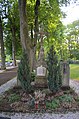
Neo-Gothic sandstone crucifix and priestly graves


House of the community
In 1978 the community house was built as a village community center .
Mayor-Daum-Platz
The village square in the center of the village offers a variety of leisure activities, for example a boules alley and a bookcase.
Web links
- Internet presence of the local community Daxweiler
- Local community Daxweiler on the website of the Verbandsgemeinde Stromberg
- Short portrait with a film about Daxweiler on SWR television
- Literature about Daxweiler in the Rhineland-Palatinate state bibliography
Individual evidence
- ↑ State Statistical Office of Rhineland-Palatinate - population status 2019, districts, communities, association communities ( help on this ).
- ↑ Official municipality directory 2006 ( Memento from December 22, 2017 in the Internet Archive ) (= State Statistical Office Rhineland-Palatinate [Hrsg.]: Statistical volumes . Volume 393 ). Bad Ems March 2006, p. 174 and 194 (PDF; 2.6 MB). Info: An up-to-date directory ( 2016 ) is available, but in the section "Territorial changes - Territorial administrative reform" it does not give any population figures.
- ↑ State Statistical Office Rhineland-Palatinate - regional data
- ^ The Regional Returning Officer RLP: City Council Election 2019 Daxweiler. Retrieved September 15, 2019 .
- ^ The Regional Returning Officer Rhineland-Palatinate: Municipal elections 2014, city and municipal council elections
- ↑ The regional returning officer RLP: direct elections 2019. see Stromberg, Verbandsgemeinde, first line of results. Retrieved September 15, 2019 .

Abtweiler | Allenfeld | Altenbamberg | Eagle swings | Floodplains | Bad Kreuznach | Bad Sobernheim | Bärenbach | Bärweiler | Becherbach | Becherbach near Kirn | Biebelsheim | Bockenau | Boos | Braunweiler | Brauweiler | Breitenheim | Bretzenheim | Bruschied | Burgsponheim | Callbach | Dalberg | Daubach | Daxweiler | Desloch | Dörrebach | Dorsheim | Duchroth | Eckenroth | Feilbingert | Frei-Laubersheim | Fürfeld | Gebroth | Guldental | Gutenberg | Hackenheim | Hahnenbach | Hallgarten | Hargesheim | Heimweiler | Heinzenberg | Hennweiler | Hergenfeld | Hochstätten | Hochstetten-Dhaun | Horbach | Hüffelsheim | Hundsbach | Ippenschied | Jeckenbach | Kellenbach | Kirn | Cherry red | Königsau | Langenlonsheim | Langenthal | Laubenheim | Listener | Lettweiler | Limbach | Löllbach | Almond | Martinstein | Meckenbach | Meddersheim | Meisenheim | Merxheim | Monzingen | Münchwald | New Bamberg | Niederhausen | Norheim | Walnut | Oberhausen an der Nahe | Oberhausen near Kirn | Oberstreit | Odernheim am Glan | Otzweiler | Pfaffen-Schwabenheim | Pleitersheim | Raumbach | Rehbach | Rehborn | Reiffelbach | Roth | Roxheim | Rudesheim | Rümmelsheim | Saint Catherine | Schloßböckelheim | Schmittweiler | Schneppenbach | Schöneberg | Black earth | Schweinschied | Schweppenhausen | Seesbach | Seibersbach | Simmertal | Summer slump | Spa bridges | Spall | Sponheim | Staudernheim | Stromberg | Tiefenthal | Traisen | Volxheim | Waldböckelheim | Waldlaubersheim | Wallhausen | Warmsroth | Hamlet near Monzingen | Weinsheim | Weitersborn | Windesheim | Winterbach | Winterburg