
Simmertal
| coat of arms | Germany map | |
|---|---|---|

|
Coordinates: 49 ° 49 ' N , 7 ° 31' E |
|
| Basic data | ||
| State : | Rhineland-Palatinate | |
| County : | Bad Kreuznach | |
| Association municipality : | Kirner Land | |
| Height : | 190 m above sea level NHN | |
| Area : | 8.08 km 2 | |
| Residents: | 1858 (Dec. 31, 2019) | |
| Population density : | 230 inhabitants per km 2 | |
| Postal code : | 55618 | |
| Area code : | 06754 | |
| License plate : | KH | |
| Community key : | 07 1 33 096 | |
| Association administration address: | Bahnhofstrasse 31 55606 Kirn |
|
| Website : | ||
| Mayoress : | Christina Bleisinger ( SPD ) | |
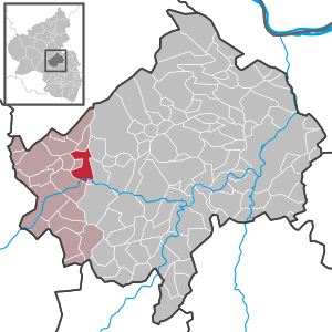
| Location of the local community Simmertal in the Bad Kreuznach district | ||
  |
||

Simmertal is a municipality in the Bad Kreuznach district in Rhineland-Palatinate . It belongs to the Kirner Land association. Simmertal is a state-approved resort . Until 1971 the community was called Simmern under Dhaun .
geography
Simmertal is located near the confluence of the Simmerbach (also called Kellenbach ) in the Nahe ( 190 m above sea level ), south of the Soonwald between Hochstetten-Dhaun in the west and Martinstein in the east. To the south of the community rises - on the other side of the Nahe - the Saar-Nahe-Bergland .
Simmertal also includes the Bergmühle, Franzhof and Simmerhammer residential areas .
history
Like Kirn and Rhaunen , the place is mentioned as "Simera" as early as 841 in a document about individual possessions of the old imperial monastery of Fulda . The Celtic origin of this name in the meaning of "water" as well as finds from Roman times are evidence of a very old settlement history of the "Simera" mark.
The imperial abbey of St. Maximin in front of Trier , which owned this remote property from King Charles III , had been in control of the land and people of this large area since 912 . was confirmed by West Franconia in the same year. From this time on, "Simera" (Symera) appears regularly in the royal and papal deeds as the manorial property of the Imperial Abbey of St. Maximin. The representation of the imperial eagle in the front half of the shield of the Simmertal coat of arms symbolizes the medieval affiliation of the village to this imperial monastery.
Within the manorial rule of St. Maximin there were still some settlements that later disappeared (e.g. Rechelnhusen, Niederau) and the villages of Brauweiler , Horbach , Martinstein , Weitersborn and Gonratherhof, which had their own landmarks in the late Middle Ages . Together, these communities formed a parish and a market cooperative with shared use of forest, water and meadows. "Simere" was the main place of this settlement association, from which the neighboring communities were also looked after.
The nucleus of the settlement, which gradually developed into a village, was the fortified Fron- or Herrenhof, the area known to the locals as the "Kuhn'sche Hof" behind the Protestant church built in 1730. A previous church consecrated to St. Maximin was mentioned in a document as early as 1140.
Around 1200 Simmern comprised twelve, in 1484 25 farms. Around 1600 there were already 69 taxable households, but these were reduced to eleven "Hausgesäß" in 1644 as a result of a wave of plague and the Thirty Years' War.
With the judicial and administrative sovereignty within the spell of Simmern, originally the Wildgraves of Dhaun were enfeoffed by the Imperial Abbey of St. Maximin . This temporary office loan was subsequently converted into an inheritance that the later Wild and Rhine Counts had through ministerials (officials). The old settlement name "Simere" became "Dhaunisch Simere" and finally to "simmering under Dhaun", meaning the country stately assignment of the place was marked. The depiction of the Dhauner lion in the back half of the shield of the Simmertal local coat of arms reminds of the fact that the village belonged to the Dhaun administrative district up to the end of the 18th century.
In 1794 the Left Bank of the Rhine was occupied during the First Coalition War , and in 1798 the area was reorganized by the French directorate based on the French model. The village of Simmern unter Dhaun was assigned to the newly formed Mairie Monzingen in the canton of Sobernheim and the arrondissement Simmern in the Rhine-Moselle department in 1798 . After the end of French rule in the area on the left bank of the Rhine (1814), Simmern under Dhaun came to the Monzingen mayor in 1816 (Monzingen office since 1927) in the Prussian district of Kreuznach . After the dissolution of the Monzingen office, Simmern came under Dhaun to the community of Kirn-Land in 1970 .
The community was renamed on January 1, 1971 in "Simmertal". The old name was retained in the name of the evangelical parish Simmern under Dhaun. The parish still includes the parishes of the medieval “Simera” rule.
- Population development
The development of the population of Simmertal, the values from 1871 to 1987 are based on censuses:

|
|
politics
Municipal council
The municipal council in Simmertal consists of 16 council members, who were elected in the local elections on May 26, 2019 in a personalized proportional representation, and the honorary local mayor as chairman.
The distribution of seats in the municipal council:
| choice | SPD | FWG | total |
|---|---|---|---|
| 2019 | 7th | 9 | 16 seats |
| 2014 | 9 | 7th | 16 seats |
| 2009 | 7th | 9 | 16 seats |
| 2004 | 9 | 7th | 16 seats |
- FWG = Free Voting Community Simmertal e. V.
mayor
Christina Bleisinger is the local mayor. In the local elections on May 26, 2019, she was elected with a share of 61.19% of the vote, making her successor to Werner Speh (SPD).
coat of arms
|
|
Blazon : "In a golden shield, split by a blue wave pole, in front a black, red-armored eagle looking to the left, behind a red, blue-tongued and armored lion." |
|
Justification of the coat of arms: The coat of arms is based on the coat of arms documented in the court seal of Simmern for the year 1568, which shows the eagle and lion in this combination. The lion refers to the former affiliation to the Wild Rhine County, the wave pole symbolizes the Simmerbach.
The municipal council commissioned the graphic artist Brust, Kirn-Sulzbach, to develop a design for a municipal coat of arms. At its meeting on February 3, 1971, the Council adopted the draft presented. |
Parish partnership
Since 1988 there has been a community partnership with the French community of Oudon .
Economy and Infrastructure
There is a kindergarten and a primary school in Simmertal . The place can be reached via the B 421 , which meets the B 41 here , as well as the Bingen - Saarbrücken railway line . Frankfurt-Hahn Airport is connected to the northwest via the first-mentioned federal road.
See also
Web links
- Simmertal near the community of Kirn-Land
- Literature about Simmertal in the Rhineland-Palatinate state bibliography
Individual evidence
- ↑ State Statistical Office of Rhineland-Palatinate - population status 2019, districts, communities, association communities ( help on this ).
- ↑ a b State Statistical Office Rhineland-Palatinate - regional data
- ↑ State Statistical Office Rhineland-Palatinate (ed.): Official directory of the municipalities and parts of the municipality. Status: January 2018 [ Version 2020 is available. ] . S. 15 (PDF; 2.2 MB).
- ↑ Local history of the community of Simmertal
- ↑ a b Statistical Maps, VG Kirn-Land, 2009
- ^ The Regional Returning Officer RLP: Municipal Council Election 2019 Simmertal. Retrieved September 21, 2019 .
- ^ The Regional Returning Officer Rhineland-Palatinate: Municipal elections 2014, city and municipal council elections
- ^ The Regional Returning Officer RLP: direct elections 2019. see Kirn-Land, Verbandsgemeinde, 16th line of results. Retrieved September 21, 2019 .

Abtweiler | Allenfeld | Altenbamberg | Eagle swings | Floodplains | Bad Kreuznach | Bad Sobernheim | Bärenbach | Bärweiler | Becherbach | Becherbach near Kirn | Biebelsheim | Bockenau | Boos | Braunweiler | Brauweiler | Breitenheim | Bretzenheim | Bruschied | Burgsponheim | Callbach | Dalberg | Daubach | Daxweiler | Desloch | Dörrebach | Dorsheim | Duchroth | Eckenroth | Feilbingert | Frei-Laubersheim | Fürfeld | Gebroth | Guldental | Gutenberg | Hackenheim | Hahnenbach | Hallgarten | Hargesheim | Heimweiler | Heinzenberg | Hennweiler | Hergenfeld | Hochstätten | Hochstetten-Dhaun | Horbach | Hüffelsheim | Hundsbach | Ippenschied | Jeckenbach | Kellenbach | Kirn | Cherry red | Königsau | Langenlonsheim | Langenthal | Laubenheim | Listener | Lettweiler | Limbach | Löllbach | Almond | Martinstein | Meckenbach | Meddersheim | Meisenheim | Merxheim | Monzingen | Münchwald | New Bamberg | Niederhausen | Norheim | Walnut | Oberhausen an der Nahe | Oberhausen near Kirn | Oberstreit | Odernheim am Glan | Otzweiler | Pfaffen-Schwabenheim | Pleitersheim | Raumbach | Rehbach | Rehborn | Reiffelbach | Roth | Roxheim | Rudesheim | Rümmelsheim | Saint Catherine | Schloßböckelheim | Schmittweiler | Schneppenbach | Schöneberg | Black earth | Schweinschied | Schweppenhausen | Seesbach | Seibersbach | Simmertal | Summer slump | Spa bridges | Spall | Sponheim | Staudernheim | Stromberg | Tiefenthal | Traisen | Volxheim | Waldböckelheim | Waldlaubersheim | Wallhausen | Warmsroth | Hamlet near Monzingen | Weinsheim | Weitersborn | Windesheim | Winterbach | Winterburg