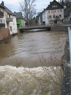
Simmerbach
|
Simmerbach Kellenbach (lower course) |
||
|
Simmerbach in the local area of Simmern |
||
| Data | ||
| Water code | EN : 2544 | |
| location |
Hunsrück
|
|
| River system | Rhine | |
| Drain over | Nahe → Rhine → North Sea | |
| source | near Wiebelsheim and Laudert 50 ° 5 ′ 24 ″ N , 7 ° 35 ′ 50 ″ E |
|
| Source height | approx. 511 m above sea level NHN | |
| muzzle | near Simmertal in the Nahe Coordinates: 49 ° 48 ′ 15 " N , 7 ° 31 ′ 26" E 49 ° 48 ′ 15 " N , 7 ° 31 ′ 26" E |
|
| Mouth height | approx. 169 m above sea level NHN | |
| Height difference | approx. 342 m | |
| Bottom slope | about 6 ‰ | |
| length | 57.2 km | |
| Catchment area | 395.058 km² | |
| Discharge at the Kellenbach A Eo gauge : 361.6 km² Location: 9 km above the mouth |
NNQ (08/27/1976) MNQ 1958/2016 MQ 1958/2016 Mq 1958/2016 MHQ 1958/2016 HHQ (12/21/1993) |
27 l / s 294 l / s 2.57 m³ / s 7.1 l / (s km²) 48.8 m³ / s 149 m³ / s |
| Small towns | Simmern / Hunsrück | |
| Navigable | by kayak and canoe | |
The Simmerbach is a 57.2 kilometer long left tributary of the Nahe in Rhineland-Palatinate ( Germany ). In the lower reaches from Gemünden the river is also called Kellenbach .
geography
course
The Simmerbach rises about 500 m above sea level in the Hunsrück near Laudert and Wiebelsheim and flows through Simmern , Ravengiersburg , Womrath-Wallenbrück , Gemünden , among others . From Gemünden the body of water is called Kellenbach. It flows into the Nahe between Kirn and Bad Sobernheim near Simmertal when coming from the north .
Tributaries
In the following, the tributaries of the Simmerbach are named in the order from the source to the mouth, which are managed by the Rhineland-Palatinate water management authority. In each case, the orographic position of the mouth, the length, the size of the catchment area, the altitude of the mouth and the river code are given.
| Surname
|
location | Length [km] |
EZG [km²] |
Mouth height [m above sea level NHN ] |
GKZ |
|---|---|---|---|---|---|
| Bach from the Schneidewald | Left | 1.7 | 2,315 | 409 | 254412 |
| Eichbach | right | 1.5 | 2,647 | 388 | 254414 |
| Grundbach | right | 7.7 | 24.723 | 379 | 25442 |
| Klingelbach | right | 4.2 | 7,868 | 369 | 254434 |
| Benzweilerbach | Left | 5.7 | 25,124 | 354 | 254436 |
| Rinkenbach | Left | 3.6 | 6.118 | 341 | 254438 |
| Külzbach | right | 13.8 | 62.829 | 323 | 25444 |
| Reichenbach | Left | 2.9 | 6.159 | 322 | 254452 |
| Holzbach | Left | 3.0 | 3,630 | 318 | 254454 |
| Verschbach | Left | 1.6 | 1.808 | 315 | 2544552 |
| Bustebach | Left | 1.4 | 1,000 | 312 | 254456 |
| Verschbach | Left | 2.4 | 1,948 | 310 | 2544572 |
| Gartenbach | Left | 2.9 | 3.019 | 308 | 254458 |
| Kauerbach | right | 12.0 | 48.867 | 299 | 25446 |
| Sülzbach | right | 5.6 | 8.412 | 299 | 254472 |
| Rolzbach | right | 4.4 | 4,941 | 299 | 254474 |
| Scheidbach | right | 4.8 | 6.470 | 290 | 254476 |
| Lametbach | Left | 11.7 | 58.150 | 283 | 25448 |
| Rohrbach | right | 4.1 | 7.354 | 273 | 254492 |
| Schlierschieder Bach | right | 3.1 | 3.209 | 279 | 2544932 |
| Asbach | Left | 4.3 | 10.791 | 231 | 254494 |
| Weitersbach | Left | 1.6 | 5.204 | 222 | 2544952 |
| Mottelbach | right | 3.1 | 6,594 | 209 | 254496 |
| Heinzenbach | right | 2.0 | 2.185 | 202 | 2544972 |
| Wiesbach | Left | 1.8 | 2.361 | 193 | 254498 |
| Apfelbach | Left | 3.2 | 3.173 | 179 | 2544992 |
Flora and fauna
The Simmerbach flows through extensively used valley meadows, on the bank there are mainly willows and alders , which are hardly used economically today. Gray herons and mallards are the most common water birds in the Bachtal. Individual specimens of the beaver have recently been observed between Simmern and Ravengiersburg .
