
Womrath
| coat of arms | Germany map | |
|---|---|---|

|
Coordinates: 49 ° 55 ' N , 7 ° 27' E |
|
| Basic data | ||
| State : | Rhineland-Palatinate | |
| County : | Rhein-Hunsrück district | |
| Association municipality : | Kirchberg (Hunsrück) | |
| Height : | 375 m above sea level NHN | |
| Area : | 8.39 km 2 | |
| Residents: | 188 (Dec. 31, 2019) | |
| Population density : | 22 inhabitants per km 2 | |
| Postal code : | 55481 | |
| Primaries : | 06763, 06765 | |
| License plate : | SIM, GOA | |
| Community key : | 07 1 40 163 | |
| Community structure: | 2 districts | |
| Association administration address: | Marktplatz 5 55481 Kirchberg (Hunsrück) |
|
| Website : | ||
| Local Mayor : | Dirk Auler | |
| Location of the local community of Womrath in the Rhein-Hunsrück district | ||
  |
||

Womrath is a municipality in the Rhein-Hunsrück district in Rhineland-Palatinate . It belongs to the Kirchberg (Hunsrück) community .
geography
Womrath is located on a ridge of the Hunsrück, southeast of Kirchberg . The hamlet of Wallenbrück and the Langenauer Mühle, both located in the Simmerbach valley, belong to the local community .
Neighboring places
| Maitzborn and Kirchberg | Rödern | Ravengiersburg and Belgweiler |
| Hedges |
.svg)
|
Crowd difference |
| Dickenschied | Gehlweiler | Gemünden |
history
Womrath has been settled since the Stone Age, as finds in the district show. From the time of the Celts , Treveri and Romans , parts of a Jupiter statue , jewelry, clay vessels and urns made of clay and copper were discovered. The Romans built a road through Womrath, which connected the Trier - Bingen trunk road from Dumnissus (today: Denzen, district of Kirchberg (Hunsrück)) with the Nahe valley and led to Cruciniacum (today: Bad Kreuznach). In 1924 a paved Roman road was detected at a depth of 50 cm.
The area remained continuously inhabited. A farm in the area of Womrath served to supply the Counts of Sponheim . The first documentary mention can be found on October 16, 1299 in an agreement on legal responsibilities in the area of Dill between the Lords of the Front and the Rear Counties of Sponheim , who were based in Bad Kreuznach and Enkirch . After the Left Bank of the Rhine was occupied by French revolutionary troops in 1794 , the place became part of France . In 1815 he was assigned to the Kingdom of Prussia at the Congress of Vienna . After the First World War, the place was temporarily occupied by the French . Since 1946 it has been part of the then newly formed state of Rhineland-Palatinate.
Until 1931 the school was attended by children from Womrath, Wallenbrück and Panzweiler . The schoolhouse from 1839/40 - today a Protestant parish hall - was paid for by Womrath for 5/6 and Panzweiler for 1/6.
Population development
| year | population |
|---|---|
| 1817 | 332 |
| 1840 | 370 |
| 1864 | 333 |
| 1905 | 288 |
| 1960 | 269 |
| 1980 | 221 |
| 1999 | 256 |
| 2014 | 194 |
people
Werner von Womrath
In 1287, the suspected murder of Werner von Womrath , who presumably fell victim to a sexual offense, is reported from Bacharach ; the corpse washed ashore was found near Oberwesel. Rumors were spread that he was the victim of a communal Jewish ritual murder on Good Friday ; Werner was employed by a Jewish family. This led to pogroms against Jews along the Middle Rhine as well as processions of “Christian charity ” to Oberwesel , where he lived, and Womrath, his hometown.
Despite many attempts, Werner was not canonized, but a Werner festival was regularly celebrated until the Catholic diocese of Trier officially removed it from its festival calendar in 1963 after Catholic church historians had proven the untenability due to internal contradictions in the legends. The Christian ritual murder legend about Werner von Oberwesel, as he is now called, seems almost typical of the time today. In Bacharach the ruins of the romantic Wernerkapelle still stand today .
Schinderhannes
In the 17th and 18th centuries, the ancestors of Johannes Bückler , known as "Schinderhannes", lived as Wasenmeister on Wallenbrück, an otherwise uninhabited hamlet in the Womrath district with five inhabitants today. At that time the Simmerbach flowing there formed the border between the margraviate of Baden and the county of Sponheim and was therefore always of interest to people on the fringes of society.
religion
Today's Protestant church was laid out in 1773 and used as a simultaneous church from 1774 to 1912 . Since then, the Protestant parish of Womrath, which belonged to the Simmern-Trarbach parish , has been the sole owner. Since the Reformation in 1557, Womrath was parishally connected to the Evangelical Church Community of Dickenschied and committed to the Reformed Confession. Paul Schneider, who was murdered in the concentration camp, worked in Womrath as a Protestant pastor from 1934 to 1937 . In 2012 Womrath was affiliated to the Evangelical Church Community Dickenschied. 136 Womrathers are currently Protestant.
The Catholics belonging to the Dickenschied parish, who make up around one sixth of the population, have their own church building, the Werner Chapel, west of the village. The construction had been preceded by a number of disputes about the use of the simultaneous church. Finally, on July 5, 1910, a contract was signed. In it it was regulated that the Catholic community receives a severance payment of 3500 Marks for their waiver of rights to the previous simultaneous church. In addition, both churches agreed that the Catholics could use the - now Protestant - church on every third Sunday of the month and for their Werner procession on April 19th. The foundation stone of the Werner Chapel was laid on October 16, 1910, and the consecration on July 2, 1911.
politics
Municipal council
The municipal council in Womrath consists of six council members, who were elected by a majority vote in the local elections on May 26, 2019 , and the honorary local mayor as chairman.
mayor
Local mayor of Womrath is Dirk Auler. In the local elections on May 26, 2019, no candidate ran, he was re-elected by the local council.
coat of arms
Blazon : "In blue 3 (2: 1) golden crosses of thorns."

The Evangelical Church of Womrath

Interior view of the Protestant church with parsonage and presbyter pews

Catholic Werner Chapel
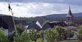
Womrath, view from the north, with Soonwald and Lützelsoon

The hamlet of Wallenbrück in the Simmerbach valley


Economy and trade
The formerly dominant agriculture has almost completely disappeared. A full-time farm, a part-time business and a horse boarding facility are still left.
literature
- Albert Rosenkranz : The Evangelical Rhineland, Volume 1 ; Series of publications by the Association for Rhenish Church History, Vol. 3; Düsseldorf: Church in Time, 1956; P. 535f;
- Dieter Diether: The houses of worship in the Evangelical Church District Simmern-Trarbach ; Kirchberg (Hunsrück): Simmern-Trarbach church district, 1998; P. 34f
- Hotte Schneider: Womrath - A village in the Hunsrück ; Womrath: Ortsgemeinde Womrath, 1999; ISBN 3-00-004779-4
See also
Web links
- Christian Gallon: Womrath. A portrait of the place. In: This country . SWR , November 5, 2004, accessed April 10, 2015 .
- Literature about Womrath in the Rhineland-Palatinate State Bibliography
Individual evidence
- ↑ State Statistical Office of Rhineland-Palatinate - population status 2019, districts, communities, association communities ( help on this ).
- ^ H. Schneider: Womrath ; P. 216
- ^ H. Schneider: Womrath ; P. 135
- ↑ Some texts speak of Maundy Thursday.
- ↑ On the whole paragraph: H. Schneider: Womrath ; P. 178
- ^ The regional returning officer RLP: Municipal council election 2019 Womrath. Retrieved October 7, 2019 .
- ^ The Regional Returning Officer RLP: direct elections 2019. see Kirchberg, Verbandsgemeinde, 38th result line. Retrieved October 7, 2019 .
- ↑ Verbandsgemeinde Kirchberg: local community Womrath. Local council. Retrieved October 7, 2019 .

Bärenbach | Belg | Büchenbeuren | Dickenschied | Dill | Dillendorf | Gehlweiler | Gemünden | Rooster | Hedges | Heinzenbach | Henau | Hirschfeld (Hunsrück) | Kappel | Kirchberg (Hunsrück) | Kludenbach | Laufersweiler | Lautzenhausen | Lindenschied | Maitzborn | Metzenhausen | Low cost | Low ears | Niederweiler | Upper cost | Raversbeuren | Reckershausen | Rödelhausen | Rödern | Rohrbach | Conclusion | Blacks | Sohren | Sohrschied | Death Red | Unzenberg | Wahlenau | Womrath | Woppenroth | Würrich

Alterkülz | Altweidelbach | Argenthal | Badenhard | Bärenbach | Belg | Belgweiler | Bell (Hunsrück) | Beltheim | Benzweiler | Bergenhausen | Bulging | Bickenbach | Beavers | Birkheim | Boppard | Braunshorn | Bubach | Book | Büchenbeuren | Budenbach | Damscheid | Dichtelbach | Dickenschied | Dill | Dillendorf | Dommershausen | Dörth | Ellern (Hunsrück) | Emmelshausen | Erbach | Fronhofen | Gehlweiler | Gemünden | Gödenroth | Gondershausen | Rooster | Halsenbach | Hasselbach | House Bay | Hedges | Heinzenbach | Henau | Hirschfeld | Hollnich | Holzbach | Horn | Hungenroth | Kappel | Karbach | Kastellaun | Keidelheim | Kirchberg (Hunsrück) | Kisselbach | Klosterkumbd | Kludenbach | Korweiler | Kratzenburg | Külz (Hunsrück) | Kümbdchen | Lahr | Laubach | Laudert | Laufersweiler | Lautzenhausen | Leiningen | Liebshausen | Lindenschied | Linger Hahn | Maisborn | Maitzborn | Mastershausen | Mengiffer | Mermuth | Metzenhausen | Michelbach | Mörschbach | Mörsdorf | Morshausen | Mill path | Mother difference | Nannhausen | Neuerkirch | Ney | Low cost | Niederburg | Niederkumbd | Low ears | Niedert | Niederweiler | Norath | Upper cost | Oberwesel | Ohlweiler | Oppertshausen | Perscheid | Pfalzfeld | Pleizenhausen | Ravengiersburg | Raversbeuren | Rayanders | Reckershausen | Empire | Rheinböllen | Riegenroth | Riesweiler | Rödelhausen | Rödern | Rohrbach | Roth | Sankt Goar | Sargenroth | Conclusion | Schnorbach | Schönborn | Torrent | Blacks | Simmern / Hunsrück | Sohren | Sohrschied | Expense red | Steinbach | Thörlingen | Tiefenbach | Death Red | Uhler | Unzenberg | Urbar | Utzenhain | Wahlbach | Wahlenau | Wiebelsheim | Womrath | Woppenroth | Würrich | Wüschheim | Zilshausen