
Kirchberg (Hunsrück)
| coat of arms | Germany map | |
|---|---|---|

|
Coordinates: 49 ° 57 ' N , 7 ° 24' E |
|
| Basic data | ||
| State : | Rhineland-Palatinate | |
| County : | Rhein-Hunsrück district | |
| Association municipality : | Kirchberg (Hunsrück) | |
| Height : | 420 m above sea level NHN | |
| Area : | 18.05 km 2 | |
| Residents: | 3993 (Dec. 31, 2019) | |
| Population density : | 221 inhabitants per km 2 | |
| Postal code : | 55481 | |
| Area code : | 06763 | |
| License plate : | SIM, GOA | |
| Community key : | 07 1 40 067 | |
| Association administration address: | Marktplatz 5 55481 Kirchberg (Hunsrück) |
|
| Website : | ||
| City Mayor : | Werner Wöllstein ( FDP ) | |
| Location of the city of Kirchberg (Hunsrück) in the Rhein-Hunsrück district | ||
 _in_SIM.svg) |
||

Kirchberg (Hunsrück) is a town in the Rhein-Hunsrück district in Rhineland-Palatinate . The administrative seat of the association of the same name is also located here .
geography
Kirchberg, the "town on the mountain", called Kerbrich in Moselle Franconian dialect , received town charter in 1259 and is therefore the oldest town on the Hunsrück . It lies at the intersection of the old road connection Trier – Kirchberg – Bingen – Mainz, the Römerstraße or Ausoniusstraße (today B 50 ), with the Keltenweg Nahe – Mosel (today B 421 and Landesstraße 184). The city center has been relieved by the B 50 bypass road since 1990. The disused railway line of the Hunsrückquerbahn Langenlonsheim – Stromberg – Rheinböllen – Simmern – Kirchberg – Hermeskeil is to be at least partially reactivated in the foreseeable future. The distance to the district town of Simmern / Hunsrück is 10 km in an easterly direction and to Frankfurt-Hahn Airport with international connections 12 km in a westerly direction.

The towers of the two churches and the characteristic water tower of the town of Kirchberg, located on a hill, can be seen from afar . From the tower of the Michaelskirche you can see: In the southeast the Soonwald with the castle ruins Koppenstein , in the south the Lützelsoon , in the southwest Idarkopf and Erbeskopf (816 m), in the northeast the area around Kastellaun , in the east the district town Simmern. To the west of Kirchberg lies the Kyrbachtal , to the east the Kauerbachtal . The Hunsrückhöhenstraße runs north of Kirchberg from Saarburg to Koblenz ( B 327 ).

Aerial photos of Kirchberg clearly show the step-by-step development of the city: The present-day district of Denzen (derived from the Celtic Dumno ), located northeast in a hollow, has its origin in a pre-Roman settlement at the old crossroads; the eastern part of the city was a military station on the Roman road from Trier over the Hunsrück to Bingen and Mainz, today called Ausoniusstraße after the Roman civil servant and poet Decimus Magnus Ausonius (approx. 310-394), who first described this route in his poem Mosella Has. The medieval city center was surrounded by a tower-reinforced wall with gate towers, the course of which is still visible today from a bird's eye view. In the period that followed, housing estates, schools and sports facilities, horticultural areas and industrial sites were built around the oval of this former city wall . The old town is still cut today by the route of the old Roman road, for the course of which the straightest possible alignment was typical.
The city area is 18 square kilometers, of which 50% is agricultural land, 30% forest, 18% built-up area and 2% other areas.
Neighboring places
| Lower cost and upper cost | Metzenhausen and Kappel | Reckershausen and Heinzenbach |
| Dillendorf |
.svg)
|
Unzenberg |
| Hedges | Dickenschied | Rödern and Maitzborn |
History and historical description of the place

The main road runs along the Ausoniusstraße from Trier to Bingen

The water tower in the west of the city (1899)

The third tower belongs to the Friedenskirche (1967) in the east of the city

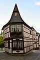
Oriel house (1698) and town hall (17th century / 1746)

Schwanen Pharmacy: half-timbered house after 1650, pharmacy since 1752
Heimathaus in Eifelgasse (1732)

Michaelskirche seen from the market square

Corner building at Marktplatz 11 (2nd half of the 17th century)

Former Baden Gendarmerie (after 1750)

St. Nepomuk (around 1750) in front of the former Baden Gendarmerie


,_Friedenskirche.jpg)

,_Schwanenapotheke.jpg)

,_St._Micha%C3%ABltsjerke_1.jpg)
,_Marktplatz_11.jpg)
,_Hauptstra%C3%9Fe_19.jpg)
,_Hauptstra%C3%9Fe_19,_Skulptur.jpg)
Archaeological finds suggest that this has been here since around 400 BC. The Celtic tribe of Treveri had settled. In the 1st century BC The Romans built the military road from Trier via Neumagen , " Stumpfer Turm " near Wederath (the Roman Belginum on the border between the Roman provinces of Belgica and Germania inferior ), Kirchberg, Bingen to Mainz ; In the eastern part of today's city of Kirchberg, the Romans built a settlement called Dumno or Vicus Dumnissus . This place name can already be found in a late antique road map from the 4th century, of which a true copy of the 12th century still exists today, the Tabula Peutingeriana, named after its discoverer . In the year 368 the Roman poet Ausonius also mentioned the place Dumnissus (= Dumno = Kirchberg) in his poem Mosella , which contains a poetic description of his journey from Bingen via the Hunsrück to Neumagen and Trier. This makes Kirchberg the oldest known settlement in the highlands between the Moselle, Rhine, Nahe and Saar.
In the 5th century, the Roman Fiskalland became the crown property of the Frankish kings. A new settlement emerged from the Roman vicus , which received a first church (wooden structure) in the 7th century at the latest, probably on the site of today's Michael’s Church. The new settlement was called "Chiriperg" (probably after the Kyrbach ), from which "Kirchberg" later emerged.
In 995 King Otto III. the former Konigsgut Denzen (praedium Domnissa) the Trechirgaugrafen Bezelin, the ancestor of the Gaugrafengeschlechts Bertholde, then the eastern half (with Denzen) the donated by them 1074 Augustine Chorherrenstift Ravengiersburg transferred. The western half (with Kirchberg) fell to the Counts of Sponheim in 1248 . Since then, the historical development of Kirchberg has been closely linked to the Sponheimers and their heirs. In 1259 Kirchberg received town charter . (A first document with minor rights had already been issued in 1249).
When the county of Sponheim was divided in the 13th century, the Kirchberg office became part of the Vorderen Grafschaft Sponheim and when the Sponheimers died out in 1437, it became part of the common rule of the Elector of the Palatinate , Margrave of Baden and Count of Veldenz (later Palatinate-Simmern ) with the seat the administration in Kirchberg. In 1689, during the War of the Palatinate Succession , French troops destroyed the city and the fortifications. The communal rule was ended by the real division of 1708, with the Kirchberg office and the Koppenstein sub-office falling to Baden ; Kirchberg became the seat of the Baden Oberamt of the same name. The last Oberamtmann in Baden was until 1794 the father of Karl Freiherr von Drais , the inventor of the first two-wheeled running machine called the Draisine . From 1798 to 1814 Kirchberg was the administrative seat of a French canton in the Simmern arrondissement of the Rhin-et-Moselle department . In 1816 the city became the seat of the Prussian mayor's office with 18 surrounding communities.
On February 10, 1928, the neighboring village of Denzen , the former Dumnissus , was incorporated into the town of Kirchberg against the resistance of the population of Denz. Since 1946 Kirchberg and Denzen have belonged to the then newly formed state of Rhineland-Palatinate.
The cityscape is characterized by three towers: the tower of the historic Michaelskirche in the center, the tower of the Evangelical Church of Peace in the east and the 36 meter high water tower in the west, which was built in 1899. The towers represent medieval history, industrialization and the modern city.
Religions
Church conditions
The large parish of Kirchberg with a central baptistery in Kirchberg and chapels in Gemünden, Dickenschied, Womrath, Denzen, Kappel, Metzenhausen, Ober Kostenz, Würrich and Altlay was established in the area of the Denzer Königsgut under the Carolingians . Until the 16th century Kirchberg was one of the most important centers on the Hunsrück. A total of 51 villages belonged to the pastoral district of Kirchberg.
Elector Ottheinrich von der Pfalz had the Kirchberg office visited in 1556 and the Lutheran creed introduced. In May 1599 there was another change of denomination: Under Elector Friedrich IV. (Palatinate) the Reformed Confession came into effect.
In the following years, the denominational relationships were determined by the sovereign or the military rulers: from 1620 under Spanish occupation after the conquest in the Thirty Years War by Lieutenant General Ambrosio Spinola again Catholic, 1631–1635 under Swedish influence, Lutheran, 1635–1648 Catholic and from 1648 reformed after the Peace of Westphalia . By treaty of 1652 the Catholics were given the right to worship in the house of the Baden clerk .
Michaelskirche

_6423.jpg)

In 1688, the use of Michaelskirche as a simultaneous church was introduced with the stipulation that Catholic and Protestant Christians were each allowed to use the Michaelskirche , which they shared in shared ownership, at certain times; The Catholics were also entitled to use the choir with the high altar, the two side altars and the confessionals alone. This simultaneum was repealed by mutual agreement by a notarial contract of June 15, 1965 and replaced by a new regulation with ecumenical objectives: The Protestant parish sold half of its stake to the Catholic parish, which enabled the seller to build the new peace church with community center. In addition, it was regulated that the Protestant parish could use the Michaelskirche until the new church was ready for occupancy and that in return the Catholic parish could be guests in the Friedenskirche until the fundamental restoration of the Michaelskirche with tower and the preceding archaeological excavations in the church area by the Office for Prehistory and Early History, Koblenz. The work was finally finished on July 6, 1969.
The archaeological excavations under Michael’s Church brought astonishing results: Today’s late Gothic hall church St. Michael had three previous stone buildings, the foundations of which could be partially exposed and prepared for inspection under the church's choir. An uninterrupted continuity of the churches in the same place from pre-Carolingian times to the present day has been established. This means that these church buildings are among the most historically important and probably also the oldest between Trier, Koblenz and Boppard.
Building I from the time after 700 was a small early Carolingian hall building with a retracted rectangular choir . In this building was u. a. the fragment of an early Christian tombstone with an inscription was found, which is held to be the oldest real testimony to the fact that Christians lived on the Hunsrück even in post-Roman times. The description says: “In addition, due to the early dating of the tombstone, it can be assumed that the early Christian community of the later Kirchberg has already gathered in a previous building of the archaeologically proven Church Building I. This was perhaps an early wooden church or even a private house used as a church meeting place. "
Building II , erected around 850, contained a hall building that was about twice as large, this time equipped with a baptismal font and a gallery in the entrance area.

Building III was a three-aisled, flat-roofed pillar basilica with a semicircular apse from the period before 1050, again with a baptismal font and western gallery. According to Seibrich, this early Romanesque church could have looked something like the church of St. Cyriak in Sulzburg / Markgräflerland , which has been preserved to this day and was consecrated only a few decades earlier (993). Today's church tower was built around 1200 on the basement of Building III and later heightened and supplemented several times.
With the room volume doubled again from 1460 to 1485, today's late Gothic hall church St. Michael was built over the foundations of the previous buildings I to III with a vestibule and main portal on the south side. Across the center post carries a Wilder Mann a Konsolstütze on which a sculpture of the Madonna or the church patron might have been. The mask-like heads on the four consoles of the double portal depict: On the right side Jesus with a crown of thorns and a cross nimbus and opposite a woman's head with a cross diadem ( Ecclesia ); on the left a faun's face with goat ears and a head with a negroid expression, interpreted as symbols of the damned.
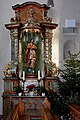
In the church interior are noteworthy above all: The in the nave of pillars distributed and vaulted ribs numerous masons' marks , the sandstone pulpit (around 1490), the grave monuments from the 15th to the 18th century with the famous tomb of Catherine of Hoising in the choir (Master Johann von Trarbach , after 1577) and several tombstones of the von Koppenstein family , the baptismal font with the alliance coat of arms of the donor families (1st half of the 18th century), the high altar and side altars as well as the organ prospect from the second half of the 18th century. The baroque painting in the caps of the choir vault was partially restored in 1969. In the middle are shown: Madonna with two female saints, baptism of Jesus , apocalypse and mercy seat ; on the sides: the twelve apostles and the four Latin doctors of the church; in the vault caps to the west: Sebastian and Rochus , Barbara and Margaretha , Florian and Martin ; In addition, juxtapositions of New Testament scenes with depictions from the life of the Carmelites who were active in Kirchberg until 1757 : Petri fishing and following Christ , depiction of Jesus in the temple and preparations for baptism in a church, whereby the last scene bears a striking resemblance to St. Michael's Church and its baptismal font. The rest of the painting of the church was designed in 1969 based on remains found and additionally based on historical models.

High altar with painting Michael fighting with Lucifer (after Guido Reni)
Marien Altar on the north side

Nepomuk altar on the south side
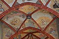
Painting of the choir vault with the twelve apostles

Organ gallery with ornate parapet

15th century stonemason's mark in the nave
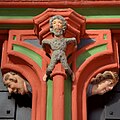
At the south portal: Wilder Mann between Ecclesia and Faunskopf.
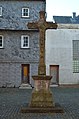
Cemetery cross from 1744 in front of the south portal

Back of the former cemetery cross

Catholic rectory, formerly a Piarist monastery from 1765
,_St._Micha%C3%ABltsjerke,_heechalter.jpg)
,_St._Micha%C3%ABltsjerke,_noardlik_sydalter.jpg)
,_St._Micha%C3%ABltsjerke,_s%C3%BAdlik_sydalter.jpg)
,_St._Micha%C3%ABltsjerke,_ferwulft_heechalter.jpg)
,_St._Micha%C3%ABltsjerke,_oargel.jpg)
,_St._Micha%C3%ABltsjerke,_portaaldekoraasje.jpg)
,_Kirchplatz,_Kreuz,_Vorderseite.jpg)
,_Kirchplatz,_Kreuz,_R%C3%BCckseite.jpg)
,_Kirchplatz_2_(1).jpg)
The church square around Michaelskirche, which served as a cemetery until 1792 , is now bordered on all sides by rows of houses. In front of the south portal there is still a cemetery cross from 1744 (copy) with the old inscription, which translates as: “This is God, as the portrait teaches; but God is not the image itself. Always worship it, but in your spirit worship what you see in it. ”On the west side is the baroque building of the former Piarist monastery from 1765, which today serves as a rectory and community center. The (restored) coat of arms above the portal shows the coat of arms of Margrave August Georg von Baden with his individual coats of arms : Front County Sponheim , County Eberstein, Breisgau , Badenweiler , Margrave Baden , Dominion Üsenberg , Rötteln , Lahr and Mahlberg , Rear County Sponheim.

Castle house with stair tower of Jakob von Eich (1578)

Old customs house

Two-story garden pavilion (around 1780)

Nikolauskapelle in Denzen with the choir tower from 1236
Weathered gravestones in the Jewish cemetery
,_Hauptstra%C3%9Fe_75.jpg)
,_Altes_Zollhaus.jpg)
,_Gartenh%C3%A4uschen,_Simmerner_Stra%C3%9Fe,_bei_Nr._25.jpg)

.jpg)
Friedenskirche
The Protestant Peace Church with community center was essentially built according to the plans of the architect Heinrich Otto Vogel , Trier. The foundation stone was taken from the portal wall of the Michael Church; the baptismal font, consisting of a stone carved in Roman times and found during the excavations under St. Michael's Church, is a gift from the Catholic parish. In return, the Protestant parish gave the Catholic parish a bronze bowl for the baptismal font in the choir of St. Michael's Church. The garden pavilion and the draw well in front of the Friedenskirche formed the center of a walled garden around 1780, which is said to have been laid out by the Baden governor at the time.
Nicholas Chapel
Today's Nikolaus Chapel in Kirchberg-Denzen with its Romanesque choir tower from 1236 also looks back on a long tradition: According to the research results, an own chapel was built as a baptistery in the area of the Denzen royal court between 650 and 700 and St. John the Baptist was consecrated as the patron saint of the church. In the Ottonian period (around 955) it was rededicated to Nikolaus von Myra , following a veneration of this saint that had arisen in the Rhineland at that time. A small hall was added to the choir tower in 1966.
Synagogue and Jewish cemetery
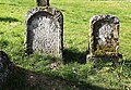
Most of the Jews who lived in Kirchberg between the 18th and 20th centuries were united in a religious community; they owned a small synagogue in today's Glöcknergasse, a religious school and their own cemetery on Metzenhausener Strasse, which is still preserved.
politics
City council
The city council consists of 20 council members, who were elected in a personalized proportional representation in the local elections on May 26, 2019 , and the chairman.
The distribution of seats in the city council:
| choice | SPD | CDU | FDP | FWG | total |
|---|---|---|---|---|---|
| 2019 | 4th | 6th | 5 | 5 | 20 seats |
| 2014 | 4th | 8th | 3 | 5 | 20 seats |
| 2009 | 4th | 8th | 4th | 4th | 20 seats |
| 2004 | 4th | 9 | 2 | 5 | 20 seats |
| 1999 | 5 | 10 | 2 | 3 | 20 seats |
mayor
- 1994-2004: Hans Dunger
- 2004–2009: Werner Elsen
- 2009–2019: Udo Kunz
- 2019– : Werner Wöllstein
Werner Wöllstein prevailed in the runoff election on June 16, 2019 with a share of the vote of 66.61% against the previous incumbent Udo Kunz, after none of the original three applicants could achieve a sufficient majority in the local election on May 26, 2019.
Coat of arms and seal
Blazon : "In red a rafter made of gold (yellow) and blue in two rows, underneath a golden (yellow) helmet crown ."
The coat of arms was modeled on the city seal from the 14th century. The chested rafter is a variant of the coat of arms of the Counts of Sponheim , Vordere Grafschaft, which Kirchberg granted city rights in 1259. The meaning of the crown is unclear; possibly it refers to the Reich loyalty of the Sponheimers. The crown appears in the coat of arms of Kastellaun and Sohren .
Town twinning
Kirchberg (Hunsrück) has a partnership with the French city of Villeneuve-l'Archevêque in Burgundy.
Education, culture and sights
In the city of Kirchberg there is a primary school and a cooperative comprehensive school. The Kirchberger Heimatmuseum in the Eifelgasse gives an impression of life in the past centuries. The buildings worth seeing include:
- Church of St. Michael (13th and 15th centuries) and church square with the Catholic rectory (1765)
- Town hall (17th century / 1746) and market square
- Half-timbered house at Marktplatz 6 with five-sided bay window (1698)
- Schwanen-Apotheke Marktplatz 4, typical half-timbered house from the 17th century (the pharmacy privilege was first granted in 1752 by the Margrave of Baden; this makes the Kirchberg pharmacy the oldest on the Hunsrück)
- Corner house with half-timbered Marktplatz 11 (2nd half of the 17th century) next to the entrance to the church square,
- Hauptstrasse 17 and 19 on the south side of the market square, built in the middle of the 18th century as the "Badische Försterei" and "Badische Gendarmerie" of the Badischer Oberamt Kirchberg (today partially replaced by renovations)
- Local history museum in Eifelgasse, half-timbered house from 1732
- Former noble court of the von Eich family, Hauptstraße 75, with stair tower and spiral staircase from 1578
- Water tower from 1899, which was integrated into the municipal water supply until a few years ago
- Historical Roman fountain in the Denzen district
- Youth center "Am Zug", since the first day of opening on February 18, 2003, an interdenominational meeting point for young people from the age of 12 with all-day care sponsored by the international humanitarian association we-SHARE (member of the joint welfare association Rhineland-Palatinate / Saarland). There are various projects and activities for children from 6 years of age (KinderKino Kirchberg, summer vacation program "KINDER AM ZUG!", Offers of artistic design)
- Evangelical Peace Church (1965–1967), built according to plans by Heinrich-Otto Vogel (Trier), on Simmerner Straße. Organ from the Oberlinger brothers (Windesheim) with 23 registers.
In 1981, Kirchberg was the location for the German feature film “Raindrops”. The autobiographical film by the Kirchberg-born author and actor Harry Raymon tells a story of Jewish children during fascism in Germany. The roles were u. a. with the actors Elfriede Irrall , Walter Renneisen , Giovanni Früh , and Pit Krüger . “Raindrops” was Film of the Month for June 1982 by the Protestant Film Work jury.
Old cityscapes

_b_102_1.jpg)
In the two important compilations of cityscapes of the 17th century by Daniel Meisner and Eberhard Kieser with the title Thesaurus philopoliticus or Politisches Schatzkästlein and by Matthäus Merian Topographia Germaniae there are also copper engravings by Kirchberg. The first-mentioned illustration "Kirchberg / Hunnor" from 1629 was made by the engraver Sebastian Furck , as indicated by the signature SF fecit . Sebastian Furck also made the copper engraving of Kastellaun , which has the following special features: In the foreground on the right, the draftsman and copper engraver Sebastian Furck (born in Alterkülz near Kastellaun in 1598) himself is shown sitting in front of the silhouette of Kastellaun his publisher Eberhard Kieser (1583 Born in Kastellaun) in front of his hometown in the picture.
The second view of the city by Matthäus Merian is from 1645; In the description of Kirchberg it says literally: "Is not big, but was well built before this war (meaning the Thirty Years War)".
An oil painting by Kirchberg (before 1610) is only preserved in old photographs. Three city plans from the years 1635, 1655 and 1688 are also revealing for the city's history.
freetime and sports
Kirchberg has an indoor and an outdoor swimming pool, several tennis courts, a tennis hall, the open youth center “Am Zug” and an indoor climbing hall. The Freiherr-von-Drais cycle path leads 14 km around the city. The Lützelsoon cycle path to Kirn begins in Kirchberg. Numerous hiking trails go into the surrounding area, including the Keltenweg and Ausoniusweg as long-distance trails. There is also a sports club, TuS Kirchberg 1909, and a handball club, HSV Kirchberg 1974.
Personalities


sons and daughters of the town
- Johannes Rulitius (1602–1666), pastor in Dorchester, Heidelberg and Amsterdam
- Sophie Reinhard (1775–1844), painter
- Wilhelm Ludwig Frommel (1795–1869), Protestant clergyman and educator, honorary citizen of Pforzheim
- Nanny Lambrecht (1868–1942), a novelist associated with the Hunsrück
- Otto Back (1834–1917), District Administrator in Simmern, Mayor of Strasbourg, President of the State Parliament
- Harry Raymon (* 1926 in Kirchberg as Harry Heymann), actor
- Barthold C. Witte (1928–2018), Ministerialbeamter
- Klaus Schmittinger (* 1950), table tennis player
Other personalities
People who lived in Kirchberg but were not born here:
- Karl Wilhelm Ludwig Friedrich Drais Freiherr von Sauerbronn (1755–1830), senior bailiff and man of letters, later president of the court of higher courts and Baden historian
- Karl von Drais (1785–1851), inventor of the two-wheeler principle and a "high-speed typewriter" with 16 keys; lived in Kirchberg as a child from 1790 to 1794
literature
- Jakob Göhl: From Kirchberg's past. Kirchberg 1949.
- City of Kirchberg (Ed.): Festschrift 700 years of the city of Kirchberg. Walter printer, Kirchberg 1949.
- Albert Rosenkranz: Kirchberg, a little history of the evgl. Parish of this Vordersponheim Oberamtsstadt. Simmern 1959.
- Ferdinand Pauly, Hans Eiden, Norbert Müller-Dietrich u. a .: St. Michael in Kirchberg. History - excavation - figure. Published by: Katholische Kirchengemeinde Kirchberg, Kirchberg 1969.
- Karl Faller: Kirchberg, the oldest town in the Hunsrück. Simmern 1974.
- Magnus Backes , Hans Caspary, Norbert Müller-Dietrich: The art monuments of the Rhein-Hunsrück district. Part 1: Former Simmern district. Munich 1977 (with extensive references).
- W. Binsfeld: Ausonius Street . In: Guide to Prehistoric and Protohistoric Monuments. Western Hunsrück. Mainz 1977.
- J. Kalb: The market square in Kirchberg. Urban architecture on the Hunsrück. In: Rheinische Heimatpflege . New episode. Vol. 18, 1981, p. 179 ff.
- Hans Georg Wehrens: St. Michael in Kirchberg / Hunsrück. Munich 1983.
- Wolfgang Seibrich: On the history of the parish St. Michael in Kirchberg. Lecture manuscript from September 27, 1985 (Catholic parish archives).
- J. Mötsch: The oldest seal of the town of Kirchberg on the Hunsrück . In: Hunsrücker Heimatblätter 1987, p. 10ff.
- Hans Georg Wehrens: The Baden coat of arms on the portal of the former Piarist monastery in Kirchberg. In: Hunsrücker Heimatblätter. 1988, p. 169 ff.
- Willi Wagner, Alfred Bauer, Peter Casper, Hans Dunger: 1000 years of Denzen 995–1995. Kirchberg 1995.
- Hans Georg Wehrens, Willi Wagner: Kirchberg in the Hunsrück (= Rheinische Kunststätten . Issue 46). Cologne 1997.
- Alfred Bauer, Hans Dunger: The Roman Kirchberg (= series of publications on the history of the city of Kirchberg. Volume 1). Kirchberg 1999.
- Hans Dunger, Willi Wagner: Kirchberg was first mentioned in 875 years (= series of publications on the history of the city of Kirchberg. Volume 5) Kirchberg 2002.
- City of Kirchberg (Ed.): Heimathaus Kirchberg. History you can touch. Compiled by Hans-Werner Johann, Kirchberg o. J.
- Hans Dunger: Kirchberg around the turn of the millennium. Memories of a Hunsrück city mayor (= series of publications on the history of the city of Kirchberg. Volume 8). Kirchberg 2006.
- Hans Dunger: The Kirchberg mayors since 1800 (= series of publications on the history of the city of Kirchberg. Volume 11). Kirchberg 2009.
- City of Kirchberg (Hrsg.): 750 years of Kirchberg city rights (= series of publications on the history of the city of Kirchberg. Volume 12). Kirchberg 2009.
- Eberhard J. Nikitsch: The inscriptions of the Rhein-Hunsrück-Kreis II, formerly Lkrs. Simmern and the western part of the former Lkrs. St. Goar (= The German Inscriptions 79, Mainzer Row 12 ), Dr. Ludwig Reichert Verlag Wiesbaden 2010.
- Michael Rathmann: Tabula Peutingeriana. The only world map from ancient times . Introduced and commented. Philipp von Zabern, Darmstadt 2016.
Web links
- Website of the Kirchberg Association
- Arno Jung: Website about the Kirchberg water tower ( Memento from June 21, 2012 in the Internet Archive )
- Hans H. Stassen: Kirchberg in the Hunsrück .
- Literature about Kirchberg in the Rhineland-Palatinate State Bibliography
Individual evidence
- ↑ State Statistical Office of Rhineland-Palatinate - population status 2019, districts, communities, association communities ( help on this ).
- ^ W. Binsfeld: Ausonius-Strasse . In: Guide to Prehistoric and Protohistoric Monuments. Western Hunsrück. Mainz 1977
- ↑ Magnus Backes, Hans Caspary, Norbert Müller-Dietrich: The art monuments of the Rhein-Hunsrück district. Part 1: Former Simmern district . Munich 1977, pp. 515f. (with detailed references)
- ^ Willi Wagner in: Hans Georg Wehrens / Willi Wagner: Kirchberg im Hunsrück ( Rheinische Kunststätten issue 46), 2nd edition Cologne 1997, p. 3ff.
- ^ Alfred Bauer, Hans Dunger: The Roman Kirchberg (= series of publications on the history of the city of Kirchberg. Volume 1). Kirchberg 1999
- ^ Michael Rathmann: Tabula Peutingeriana. The only world map from ancient times . Introduced and commented. Philipp von Zabern, Darmstadt 2016
- ↑ Stadt Kirchberg (ed.): 750 years of Kirchberg town rights (= series of publications on the history of the town of Kirchberg. Volume 12). Kirchberg 2009
- ^ City of Kirchberg (ed.): Festschrift 700 years of the city of Kirchberg . Walter printer, Kirchberg 1949
- ^ Willi Wagner in: Hans Georg Wehrens / Willi Wagner: Kirchberg im Hunsrück ( Rheinische Kunststätten Heft 46), 2nd edition Cologne 1997, p. 5
- ↑ Hans Eiden and Norbert Müller-Dietrich in: Ferdinand Pauly, Hans Eiden, Norbert Müller-Dietrich u. a .: St. Michael in Kirchberg. History - excavation - figure . Ed .: Katholische Kirchengemeinde Kirchberg, Kirchberg 1969, pp. 13-17
- ↑ see Eberhard J. Nikitsch with picture and description
- ↑ Wolfgang Seibrich: On the history of the parish St. Michael in Kirchberg. Lecture manuscript from September 27, 1985 (Catholic parish archive)
- ^ HG Wehrens in: Hans Georg Wehrens / Willi Wagner: Kirchberg im Hunsrück ( Rheinische Kunststätten Heft 46), 2nd edition Cologne 1997, p. 7ff.
- ^ HG Wehrens in: Hans Georg Wehrens / Willi Wagner: Kirchberg im Hunsrück ( Rheinische Kunststätten Heft 46), 2nd edition Cologne 1997, p. 12ff.
- ^ Hans Georg Wehrens: St. Michael in Kirchberg / Hunsrück . Schnell & Steiner, Munich 1983, p. 14f.
- ^ HG Wehrens in: Hans Georg Wehrens / Willi Wagner: Kirchberg im Hunsrück ( Rheinische Kunststätten booklet 46), 2nd edition Cologne 1997, pp. 20f.
- ^ HG Wehrens in: Hans Georg Wehrens / Willi Wagner: Kirchberg im Hunsrück ( Rheinische Kunststätten Heft 46), 2nd edition Cologne 1997, p. 21
- ^ HG Wehrens in: Hans Georg Wehrens / Willi Wagner: Kirchberg im Hunsrück ( Rheinische Kunststätten Heft 46), 2nd edition Cologne 1997, p. 21.
- ^ The Regional Returning Officer RLP: City Council Election 2019 Kirchberg (Hunsrück), City. Retrieved October 7, 2019 .
- ^ The Regional Returning Officer Rhineland-Palatinate: Municipal elections 2014, city and municipal council elections
- ↑ Markus Lorenz: Local election in Kirchberg: Ex-Mayor wants to know again . Rhein-Zeitung , April 24, 2014, accessed on January 24, 2018.
- ↑ Hans Dunger: The Kirchberg mayors since 1800 (= series of publications on the history of the city of Kirchberg. Volume 11). Kirchberg 2009.
- ↑ Werner Elsen passed away . Rhein-Zeitung, January 15, 2018, accessed on January 24, 2018.
- ^ The election events in the Rhein-Hunsrück-Kreis . Rhein-Zeitung, May 25, 2014, accessed on January 24, 2018.
- ^ The Regional Returning Officer RLP: direct elections 2019. see Kirchberg, Verbandsgemeinde, 15th line of results. Retrieved October 7, 2019 .
- ↑ Charlotte Krämer-Schick: Clear vote in Kirchberg - Werner Wöllstein is the new city boss. Rhein-Hunsrück-Zeitung, June 16, 2019, accessed on October 7, 2019 .
- ^ J. Mötsch: The oldest seal of the town of Kirchberg on the Hunsrück . In: Hunsrücker Heimatblätter 1987, p. 10ff.
- ↑ Klemens Stadler : Deutsche Wappen , Volume 2: The municipal coats of arms of Rhineland-Palatinate and Saarland, Bremen, Hamburg, West Berlin: Addendum and corrections to Volume 1 . Angelsachsen-Verlag, Bremen, 1966, DNB 458203432 , p. 38
- ^ J. Kalb: The market place in Kirchberg. Urban architecture on the Hunsrück . In: Rheinische Heimatpflege. New episode. Vol. 18, 1981, p. 179 ff.
- ^ City of Kirchberg (ed.): Heimathaus Kirchberg. History you can touch . Compiled by Hans-Werner Johann, Kirchberg o. J.
- ^ "Raindrops" on the website of the Filmkulturelles Zentrum, a department in the joint venture of Evangelische Publizistik gGmbH (GEP)
- ^ Willi Wagner in: Hans Georg Wehrens / Willi Wagner: Kirchberg im Hunsrück ( Rheinische Kunststätten Heft 46), 2nd edition Cologne 1997, p. 6f.

Bärenbach | Belg | Büchenbeuren | Dickenschied | Dill | Dillendorf | Gehlweiler | Gemünden | Rooster | Hedges | Heinzenbach | Henau | Hirschfeld (Hunsrück) | Kappel | Kirchberg (Hunsrück) | Kludenbach | Laufersweiler | Lautzenhausen | Lindenschied | Maitzborn | Metzenhausen | Low cost | Low ears | Niederweiler | Upper cost | Raversbeuren | Reckershausen | Rödelhausen | Rödern | Rohrbach | Conclusion | Blacks | Sohren | Sohrschied | Death Red | Unzenberg | Wahlenau | Womrath | Woppenroth | Würrich

Alterkülz | Altweidelbach | Argenthal | Badenhard | Bärenbach | Belg | Belgweiler | Bell (Hunsrück) | Beltheim | Benzweiler | Bergenhausen | Bulging | Bickenbach | Beavers | Birkheim | Boppard | Braunshorn | Bubach | Book | Büchenbeuren | Budenbach | Damscheid | Dichtelbach | Dickenschied | Dill | Dillendorf | Dommershausen | Dörth | Ellern (Hunsrück) | Emmelshausen | Erbach | Fronhofen | Gehlweiler | Gemünden | Gödenroth | Gondershausen | Rooster | Halsenbach | Hasselbach | House Bay | Hedges | Heinzenbach | Henau | Hirschfeld | Hollnich | Holzbach | Horn | Hungenroth | Kappel | Karbach | Kastellaun | Keidelheim | Kirchberg (Hunsrück) | Kisselbach | Klosterkumbd | Kludenbach | Korweiler | Kratzenburg | Külz (Hunsrück) | Kümbdchen | Lahr | Laubach | Laudert | Laufersweiler | Lautzenhausen | Leiningen | Liebshausen | Lindenschied | Linger Hahn | Maisborn | Maitzborn | Mastershausen | Mengiffer | Mermuth | Metzenhausen | Michelbach | Mörschbach | Mörsdorf | Morshausen | Mill path | Mother difference | Nannhausen | Neuerkirch | Ney | Low cost | Niederburg | Niederkumbd | Low ears | Niedert | Niederweiler | Norath | Upper cost | Oberwesel | Ohlweiler | Oppertshausen | Perscheid | Pfalzfeld | Pleizenhausen | Ravengiersburg | Raversbeuren | Rayanders | Reckershausen | Empire | Rheinböllen | Riegenroth | Riesweiler | Rödelhausen | Rödern | Rohrbach | Roth | Sankt Goar | Sargenroth | Conclusion | Schnorbach | Schönborn | Torrent | Blacks | Simmern / Hunsrück | Sohren | Sohrschied | Expense red | Steinbach | Thörlingen | Tiefenbach | Death Red | Uhler | Unzenberg | Urbar | Utzenhain | Wahlbach | Wahlenau | Wiebelsheim | Womrath | Woppenroth | Würrich | Wüschheim | Zilshausen