
Pfalzfeld
| coat of arms | Germany map | |
|---|---|---|

|
Coordinates: 50 ° 7 ' N , 7 ° 35' E |
|
| Basic data | ||
| State : | Rhineland-Palatinate | |
| County : | Rhein-Hunsrück district | |
| Association municipality : | Hunsrück-Middle Rhine | |
| Height : | 440 m above sea level NHN | |
| Area : | 5.27 km 2 | |
| Residents: | 615 (Dec. 31, 2019) | |
| Population density : | 117 inhabitants per km 2 | |
| Postal code : | 56291 | |
| Area code : | 06746 | |
| License plate : | SIM, GOA | |
| Community key : | 07 1 40 117 | |
| LOCODE : | DE ZED | |
| Community structure: | 2 districts | |
| Association administration address: | Rathausstrasse 1 56281 Emmelshausen |
|
| Website : | ||
| Local Mayor : | Rainer Steeg | |
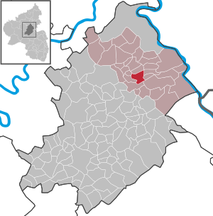
| Location of the local community Pfalzfeld in the Rhein-Hunsrück district | ||
  |
||

Pfalzfeld is a municipality in the Rhein-Hunsrück district in Rhineland-Palatinate . It belongs to the Hunsrück-Mittelrhein community .
Geographical location
Pfalzfeld is centrally located in the Hunsrück between Emmelshausen and Kastellaun , directly on the Schinderhannes cycle path .
The district of Nenzhäuserhof ( 520 m above sea level ) belongs to the municipality of Pfalzfeld .
history
In 893 the place was first mentioned in the Prümer Urbar . Later it belonged to the Lower County of Katzenelnbogen and was the seat of the Vogtei Pfalzfeld. The Vogtei was given to the Lords of Braunshorn as a Katzenelnbogen fief until 1367 . In addition to Pfalzfeld, the bailiwick included the villages of Badenhard , Hausbay (partly), Hungenroth ( Hüncherodt ), Mühlpfad , Niedert and Utzenhain . The Vogtei Pfalzfeld was part of the Niedergrafschaft Katzenelnbogen until the end of the 18th century and belonged to the Rheinfels office .
After the occupation of the Left Bank of the Rhine (1794) by French revolutionary troops , the place became French . Pfalzfeld was subordinate to the canton Sankt Goar in the Rhine-Moselle department from 1798 to 1814 .
At the Congress of Vienna (1815) the region and thus Pfalzfeld was assigned to the Kingdom of Prussia . From the French Mairie emerged mayoralty Pfalzfeld in 1816 the newly formed district of St. Goar in Koblenz assigned, that of 1822 to the Rhine province belonged.
After the First World War temporarily occupied by the French , the place has been part of the state of Rhineland-Palatinate since 1946 .
In 1993, the town's 1100th birthday was celebrated as part of a large local festival.
politics
Municipal council
The local council in Pfalzfeld consists of twelve council members, who were elected in the local elections on May 26, 2019 in a majority vote, and the honorary local mayor as chairman.
mayor
Local mayor is Rainer Steeg. In the local elections on May 26, 2019, the previous mayor, Peter Hammes, narrowly missed re-election with 47.15% of the vote, so a repeat election was necessary.
coat of arms
|
|
Blazon : "In gold an erect red obelisk , which shows a human head with a winged hood and surrounding tendrils." |
|
Justification for the coat of arms: The obelisk represents the so-called Celtic column (see Pfalzfeld column ), which was found in Pfalzfeld in 1649. The colors indicate that Pfalzfeld belonged to the Lower County of Katzenelnbogen until the end of the old empire.
The "column" dates from the 4th century BC. BC and represents one of the most important testimonies of the Latène period . Today the column is in the Rheinisches Landesmuseum in Bonn . |
Buildings
- historic water tower near Pfalzfeld
- Protestant church
- Copy of the “Pfalzfelder column” from 1993 in the center of the village
See also: List of cultural monuments in Pfalzfeld
- Views of landmarks

Schinderhannes cycle path in the Pfalzfeld area, train station

Historic water tower

Main street in the center

The Pfalzfelder column in the Rheinisches Landesmuseum in Bonn

Evangelical Church Pfalzfeld with evening lighting


traffic
The Pfalzfeld train station was on the Hunsrück Railway , which is now only used to Emmelshausen . The remaining part to Simmern has been closed and converted into the Schinderhannes cycle path .
Personalities
- Heinz-Peter Baecker (1945–2015), photographer, cameraman, journalist, screenwriter, director and since 1997 also a writer
Web links
- Website of the local community Pfalzfeld
- Literature about Pfalzfeld in the Rhineland-Palatinate State Bibliography
Individual evidence
- ↑ State Statistical Office of Rhineland-Palatinate - population status 2019, districts, communities, association communities ( help on this ).
- ↑ State Statistical Office Rhineland-Palatinate (ed.): Official directory of the municipalities and parts of the municipality. Status: January 2019 [ Version 2020 is available. ] . S. 56 (PDF; 3 MB).
- ^ Wilhelm von der Nahmer: Handbook of the Rhenish Particular Law. Volume 3. Sauerländer, 1832, p. 556 ( online at Google Books )
- ^ The Regional Returning Officer Rhineland-Palatinate: City Council Election 2019 Pfalzfeld. Retrieved October 5, 2019 .
- ↑ The Regional Returning Officer Rhineland-Palatinate: direct elections 2019. Retrieved on October 5, 2019 (see Hunsrück-Mittelrhein, Verbandsgemeinde, 29th line of results).
- ^ Local community Pfalzfeld: election to local council and mayor. September 14, 2019, accessed October 5, 2019 .

Alterkülz | Altweidelbach | Argenthal | Badenhard | Bärenbach | Belg | Belgweiler | Bell (Hunsrück) | Beltheim | Benzweiler | Bergenhausen | Bulging | Bickenbach | Beavers | Birkheim | Boppard | Braunshorn | Bubach | Book | Büchenbeuren | Budenbach | Damscheid | Dichtelbach | Dickenschied | Dill | Dillendorf | Dommershausen | Dörth | Ellern (Hunsrück) | Emmelshausen | Erbach | Fronhofen | Gehlweiler | Gemünden | Gödenroth | Gondershausen | Rooster | Halsenbach | Hasselbach | House Bay | Hedges | Heinzenbach | Henau | Hirschfeld | Hollnich | Holzbach | Horn | Hungenroth | Kappel | Karbach | Kastellaun | Keidelheim | Kirchberg (Hunsrück) | Kisselbach | Klosterkumbd | Kludenbach | Korweiler | Kratzenburg | Külz (Hunsrück) | Kümbdchen | Lahr | Laubach | Laudert | Laufersweiler | Lautzenhausen | Leiningen | Liebshausen | Lindenschied | Linger Hahn | Maisborn | Maitzborn | Mastershausen | Mengiffer | Mermuth | Metzenhausen | Michelbach | Mörschbach | Mörsdorf | Morshausen | Mill path | Mother difference | Nannhausen | Neuerkirch | Ney | Low cost | Niederburg | Niederkumbd | Low ears | Niedert | Niederweiler | Norath | Upper cost | Oberwesel | Ohlweiler | Oppertshausen | Perscheid | Pfalzfeld | Pleizenhausen | Ravengiersburg | Raversbeuren | Rayanders | Reckershausen | Empire | Rheinböllen | Riegenroth | Riesweiler | Rödelhausen | Rödern | Rohrbach | Roth | Sankt Goar | Sargenroth | Conclusion | Schnorbach | Schönborn | Torrent | Blacks | Simmern / Hunsrück | Sohren | Sohrschied | Expense red | Steinbach | Thörlingen | Tiefenbach | Death Red | Uhler | Unzenberg | Urbar | Utzenhain | Wahlbach | Wahlenau | Wiebelsheim | Womrath | Woppenroth | Würrich | Wüschheim | Zilshausen