
Tiefenbach (Hunsrück)
| coat of arms | Germany map | |
|---|---|---|

|
Coordinates: 49 ° 56 ' N , 7 ° 33' E |
|
| Basic data | ||
| State : | Rhineland-Palatinate | |
| County : | Rhein-Hunsrück district | |
| Association municipality : | Simmern-Rheinböllen | |
| Height : | 361 m above sea level NHN | |
| Area : | 5.79 km 2 | |
| Residents: | 750 (Dec. 31, 2019) | |
| Population density : | 130 inhabitants per km 2 | |
| Postal code : | 55471 | |
| Area code : | 06761 | |
| License plate : | SIM, GOA | |
| Community key : | 07 1 40 150 | |
| Association administration address: | Brühlstrasse 2 55469 Simmern / Hunsrück |
|
| Website : | ||
| Local Mayor : | Thorsten Fuchs (FWG) | |
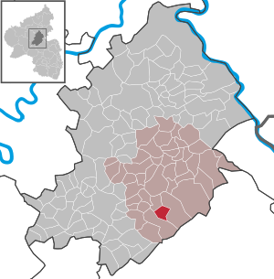
| Location of the local community Tiefenbach in the Rhein-Hunsrück district | ||
  |
||

Tiefenbach is a municipality in the Hunsrück in the Rhein-Hunsrück district in Rhineland-Palatinate . It belongs to the Simmern-Rheinböllen community . Tiefenbach grew together from the districts of Unter- and Obertiefenbach .


geography
Tiefenbach is located in the middle of the Hunsrück in the valley of the Brühlbach on the north side of the Soonwald .
| Wimmersbacher Hof | Holzbach | Riesweiler |
| Belgweiler |
.svg)
|
the Soonwald |
| Sargenroth and Mengigart |
history
The early history of Tiefenbach is connected with the Wildburg , which was first mentioned in a document in 1253. Later, Tiefenbach, located at the northern foot of the Soonwald, was part of Pfalz-Simmern , which introduced the Reformation in 1556 . In 1673 the place became part of the Electoral Palatinate and became part of France with the occupation of the left bank of the Rhine in 1794 by French revolutionary troops . In 1815 he was assigned to the Kingdom of Prussia at the Congress of Vienna . In 1912 a Catholic chapel was built. After the First World War, the place was temporarily occupied by the French again . In the 1930s, the local ore mine in Märkerei was shut down. Since 1946 the place has been part of the then newly formed state of Rhineland-Palatinate . In 1961 the Protestant church was built.
In 1921, Tiefenbach received a railway connection with a station building, this Simmern – Gemünden (Hunsrück) railway line was shut down in 1963, and all tracks were removed by 1965. Until 2006 there was still a viaduct from the line , which was then blown up because it was dilapidated. The embankment is still standing northeast of Tiefenbach. The dam's last underpass was demolished in August 2009.
politics
Municipal council
The municipal council in Tiefenbach consists of twelve council members, who were elected in a personalized proportional representation in the local elections on May 26, 2019 , and the honorary local mayor as chairman.
The distribution of seats in the municipal council:
| choice | FWG | WGS | total |
|---|---|---|---|
| 2019 | 9 | 3 | 12 seats |
| 2014 | 8th | 4th | 12 seats |
- FWG = Free Voting Group Tiefenbach e. V.
- WGS = Schuch voter group
Local mayor
The local mayor is Thorsten Fuchs (FWG). In the local elections on May 26, 2019, he was elected with a share of 64.62% of the vote and is the successor to Klaus Imig, who did not run again.
coat of arms
On top of the diamond pattern, the coat of arms shows the Electoral Palatinate hammer and mallet for the former iron mine. The Palatinate lion in the lower right corner also refers to the earlier rule of the Electoral Palatinate. The silver ribbon buckle in the right half stands for the barons of Schmidtburg , the wild counts , who had several farms in the village . The coat of arms was approved by the then district government of Koblenz on September 22, 1980 .
Culture and sights
Buildings
- Catholic Church of St. Francis Xavier
- Figure of Mary on the slope
- Old ore mine
- Wildburg
See also: List of cultural monuments in Tiefenbach
village life
The Wildburghalle was built as a multi-purpose hall in 1988. Several clubs, including a men's choir (the oldest local club, founded in 1903), a sports club , a motor sports club and the volunteer fire brigade , create social and cultural life in the village. There is also a Protestant kindergarten .
tourism
The Schinderhannes-Soonwald cycle path from Gemünden to Simmern runs through the village. The newly created “Soonwaldsteig” hiking trail is further away.
Infrastructure
The Tiefenbach volunteer fire brigade provides defensive fire protection and general help, especially at the local level.
Web links
- Literature about Tiefenbach in the Rhineland-Palatinate State Bibliography
literature
- Fritz Schellack: Chronicle Tiefenbach . Ed .: Local community Tiefenbach. Tiefenbach / Simmern 2007.
Individual evidence
- ↑ State Statistical Office of Rhineland-Palatinate - population status 2019, districts, communities, association communities ( help on this ).
- ↑ a b Fritz Schellack: Chronicle Tiefenbach . Ed .: Local community Tiefenbach. Tiefenbach / Simmern 2007.
- ↑ The Simmern – Gemünden line: Part 2 - Operation, decline and dismantling. In: Hunsrückerquerbahn. Archive Eisenbahnfreunde Simmern e. V., archived from the original on June 15, 2017 ; accessed on June 8, 2018 .
- ^ The Regional Returning Officer RLP: Municipal Council Election 2019 Tiefenbach. Retrieved October 4, 2019 .
- ^ The Regional Returning Officer Rhineland-Palatinate: Municipal elections 2014, city and municipal council elections
- ^ The Regional Returning Officer RLP: direct elections 2019. see Simmern-Rheinböllen, Verbandsgemeinde, 44th result line. Retrieved October 4, 2019 .

Alterkülz | Altweidelbach | Argenthal | Badenhard | Bärenbach | Belg | Belgweiler | Bell (Hunsrück) | Beltheim | Benzweiler | Bergenhausen | Bulging | Bickenbach | Beavers | Birkheim | Boppard | Braunshorn | Bubach | Book | Büchenbeuren | Budenbach | Damscheid | Dichtelbach | Dickenschied | Dill | Dillendorf | Dommershausen | Dörth | Ellern (Hunsrück) | Emmelshausen | Erbach | Fronhofen | Gehlweiler | Gemünden | Gödenroth | Gondershausen | Rooster | Halsenbach | Hasselbach | House Bay | Hedges | Heinzenbach | Henau | Hirschfeld | Hollnich | Holzbach | Horn | Hungenroth | Kappel | Karbach | Kastellaun | Keidelheim | Kirchberg (Hunsrück) | Kisselbach | Klosterkumbd | Kludenbach | Korweiler | Kratzenburg | Külz (Hunsrück) | Kümbdchen | Lahr | Laubach | Laudert | Laufersweiler | Lautzenhausen | Leiningen | Liebshausen | Lindenschied | Linger Hahn | Maisborn | Maitzborn | Mastershausen | Mengiffer | Mermuth | Metzenhausen | Michelbach | Mörschbach | Mörsdorf | Morshausen | Mill path | Mother difference | Nannhausen | Neuerkirch | Ney | Low cost | Niederburg | Niederkumbd | Low ears | Niedert | Niederweiler | Norath | Upper cost | Oberwesel | Ohlweiler | Oppertshausen | Perscheid | Pfalzfeld | Pleizenhausen | Ravengiersburg | Raversbeuren | Rayanders | Reckershausen | Empire | Rheinböllen | Riegenroth | Riesweiler | Rödelhausen | Rödern | Rohrbach | Roth | Sankt Goar | Sargenroth | Conclusion | Schnorbach | Schönborn | Torrent | Blacks | Simmern / Hunsrück | Sohren | Sohrschied | Expense red | Steinbach | Thörlingen | Tiefenbach | Death Red | Uhler | Unzenberg | Urbar | Utzenhain | Wahlbach | Wahlenau | Wiebelsheim | Womrath | Woppenroth | Würrich | Wüschheim | Zilshausen