
Korweiler
| coat of arms | Germany map | |
|---|---|---|

|
Coordinates: 50 ° 6 ′ N , 7 ° 25 ′ E |
|
| Basic data | ||
| State : | Rhineland-Palatinate | |
| County : | Rhein-Hunsrück district | |
| Association municipality : | Kastellaun | |
| Height : | 340 m above sea level NHN | |
| Area : | 2.43 km 2 | |
| Residents: | 78 (Dec. 31, 2019) | |
| Population density : | 32 inhabitants per km 2 | |
| Postal code : | 56288 | |
| Area code : | 06762 | |
| License plate : | SIM, GOA | |
| Community key : | 07 1 40 073 | |
| Association administration address: | Kirchstrasse 1 56288 Kastellaun |
|
| Website : | ||
| Local Mayor : | Georg Wagner | |
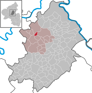
| Location of the local community Korweiler in the Rhein-Hunsrück district | ||
  |
||

Korweiler , called Korwel, official spelling until December 6, 1935: Corweiler, is a municipality in the Rhein-Hunsrück district in Rhineland-Palatinate . It belongs to the community of Kastellaun .
geography
Korweiler is located in the northern Hunsrück on a ridge east of the Dünnbach valley .
Location description

Korweiler is a typical Hunsrück Haufendorf, which is grouped around its Catholic church. The one-nave church, the Bartholomäuskapelle , built in 1907 , is dedicated to St. Bartholomäus . Once a year the congregation meets for the “congregation day” in the former school, a typical brick building, to eat, drink, “chat” and go over what has happened again.
history
The oldest evidence of settlement comes from the early La Tène period . Iron Age settlement groups were discovered to the south-east of the town in 1939/40 when dirt roads were being laid out. According to the ceramics found, they are around 2400 years old and can be attributed to the younger Hunsrück-Eifel culture . No further research was carried out at the time, but it is very likely that Iron Age houses were located here.
Today's place was first mentioned in 1307 as "Corwilre". According to the document, Sibodo von Schmidtberg donated his goods located in “Corwilre” to the Kumbd monastery , which in the following centuries until modern times owned a farm, serfs and income in the village.
Although Korweiler belonged to the rule and castle of Waldeck since the late Middle Ages or the early modern period , the place took a special position within the rule of Waldeck due to the Kumbder properties and rights . However, the Boos at Waldeck held the umbrella money for a long time, i. H. the rights and income of the monastery courtyard Kumbd. The rule of Waldeck was directly imperial from the 16th century at the latest and, in addition to the grounds of the castle itself, included the villages of Dorweiler , Mannebach and Korweiler as well as the deserted area of Hausen near Beltheim . Despite belonging to the Waldeck rule, all Korweiler residents were considered "Willibrord children", i.e. H. as originally belonging to a fiefdom of the Abbey of Sankt Willibrord in Echternach. From this multiple affiliation, disagreements arose again and again in the early modern period with the Knights of Waldeck, which led to conflicts and comparisons up to and including the Imperial Court of Justice.
In 1711 the place burned down, including the Kumbschen Erbhof for the most part and was rebuilt. As a result, only a few buildings have survived that are older than the 18th century.
In 1794 the region was occupied by French revolutionary troops, in 1798 it was incorporated into the Rhin-et-Moselle department and thus French until 1814. As a result of the redistribution of the territories agreed at the Congress of Vienna , substantial parts of the Rhineland , including Korweiler, became part of the Kingdom of Prussia in 1815 . Since 1946 the place has been part of the then newly formed state of Rhineland-Palatinate.
- Population development
The development of the population of Korweiler, the values from 1871 to 1987 are based on censuses:

|
|
|
politics
Municipal council
The council in Korweiler consists of six council members, who in the local elections on May 26, 2019 in a majority vote were elected, and the honorary mayor as chairman.
mayor
Local mayor is Georg Wagner. In the local elections on May 26, 2019, he was confirmed in his office with a share of 76.74% of the votes.
dialect
The Moselle-Franconian dialect of the region is still spoken by a majority of the inhabitants, although the number of those who actively speak and use the dialect is decreasing.
See also
Web links
- Korweiler on the website of the Association of Kastellaun
- Literature about Korweiler in the Rhineland-Palatinate State Bibliography
Individual evidence
- ↑ a b State Statistical Office of Rhineland-Palatinate - population status 2019, districts, municipalities, association communities ( help on this ).
- ^ Official register of municipalities for the German Reich (= Statistics of the German Reich . Volume 450 ). Part I. Berlin 1939, p. 267 .
- ^ Community population statistics . KommWis, accessed on December 29, 2017 .
- ^ The Regional Returning Officer RLP: City Council Election 2019 Korweiler. Retrieved October 7, 2019 .
- ^ The Regional Returning Officer RLP: direct elections 2019. see Kastellaun, Verbandsgemeinde, 26th line of results. Retrieved October 7, 2019 .

Alterkülz | Altweidelbach | Argenthal | Badenhard | Bärenbach | Belg | Belgweiler | Bell (Hunsrück) | Beltheim | Benzweiler | Bergenhausen | Bulging | Bickenbach | Beavers | Birkheim | Boppard | Braunshorn | Bubach | Book | Büchenbeuren | Budenbach | Damscheid | Dichtelbach | Dickenschied | Dill | Dillendorf | Dommershausen | Dörth | Ellern (Hunsrück) | Emmelshausen | Erbach | Fronhofen | Gehlweiler | Gemünden | Gödenroth | Gondershausen | Rooster | Halsenbach | Hasselbach | House Bay | Hedges | Heinzenbach | Henau | Hirschfeld | Hollnich | Holzbach | Horn | Hungenroth | Kappel | Karbach | Kastellaun | Keidelheim | Kirchberg (Hunsrück) | Kisselbach | Klosterkumbd | Kludenbach | Korweiler | Kratzenburg | Külz (Hunsrück) | Kümbdchen | Lahr | Laubach | Laudert | Laufersweiler | Lautzenhausen | Leiningen | Liebshausen | Lindenschied | Linger Hahn | Maisborn | Maitzborn | Mastershausen | Mengiffer | Mermuth | Metzenhausen | Michelbach | Mörschbach | Mörsdorf | Morshausen | Mill path | Mother difference | Nannhausen | Neuerkirch | Ney | Low cost | Niederburg | Niederkumbd | Low ears | Niedert | Niederweiler | Norath | Upper cost | Oberwesel | Ohlweiler | Oppertshausen | Perscheid | Pfalzfeld | Pleizenhausen | Ravengiersburg | Raversbeuren | Rayanders | Reckershausen | Empire | Rheinböllen | Riegenroth | Riesweiler | Rödelhausen | Rödern | Rohrbach | Roth | Sankt Goar | Sargenroth | Conclusion | Schnorbach | Schönborn | Torrent | Blacks | Simmern / Hunsrück | Sohren | Sohrschied | Expense red | Steinbach | Thörlingen | Tiefenbach | Death Red | Uhler | Unzenberg | Urbar | Utzenhain | Wahlbach | Wahlenau | Wiebelsheim | Womrath | Woppenroth | Würrich | Wüschheim | Zilshausen