
Dead red
| coat of arms | Germany map | |
|---|---|---|

|
Coordinates: 49 ° 59 ' N , 7 ° 21' E |
|
| Basic data | ||
| State : | Rhineland-Palatinate | |
| County : | Rhein-Hunsrück district | |
| Association municipality : | Kirchberg (Hunsrück) | |
| Height : | 390 m above sea level NHN | |
| Area : | 1.56 km 2 | |
| Residents: | 75 (Dec. 31, 2019) | |
| Population density : | 48 inhabitants per km 2 | |
| Postal code : | 55481 | |
| Area code : | 06763 | |
| License plate : | SIM, GOA | |
| Community key : | 07 1 40 151 | |
| Association administration address: | Marktplatz 5 55481 Kirchberg (Hunsrück) |
|
| Website : | ||
| Local Mayor : | Carsten Neuls | |
| Location of the local community of Todenroth in the Rhein-Hunsrück district | ||
  |
||

Todenroth is a municipality in the Rhein-Hunsrück district in Rhineland-Palatinate . It belongs to the Kirchberg (Hunsrück) community .
geography
Todenroth is located on the upper reaches of the Kyrbach on the central Hunsrück plateau. The agricultural community has an area of 1.56 km², of which 0.36 km² is forest.
history
The village was first mentioned in 1310 in the Sponheim slope register . With the occupation of the left bank of the Rhine in 1794 by French revolutionary troops , the place became French, in 1815 it was assigned to the Kingdom of Prussia at the Congress of Vienna . The Evangelical Church, a neo-Gothic hall church, was built in 1894. Since 1946 the place has been part of the state of Rhineland-Palatinate.
Religions
The Evangelical Church Community of Todenroth, to which Kludenbach and Metzenhausen also belonged, merged in 1978 with the Evangelical Church Community of Ober Kostenz .
politics
Municipal council
The municipal council in Todenroth consists of six council members, who were elected by a majority vote in the local elections on May 26, 2019 , and the honorary local mayor as chairman.
mayor
Local mayor is Carsten Neuls. In the local elections on May 26, 2019, he was confirmed in his office with 88.64% of the votes.
coat of arms
The description of the coat of arms reads: “In blue a curled golden tip, in it three black mill wheels 1: 2. In front a golden church. In the back three golden ears of corn. "
The colors blue and gold refer to the former affiliation to the front county of Sponheim . The church refers to the house of God towering over the place. The ears of wheat symbolize the former agricultural character of the community and the three mill wheels are reminiscent of the three mills in the village in the Kyrbachtal .
The coat of arms was approved on January 15, 1993 by the district administration of the Rhein-Hunsrück district .
Views of Todenroth

Todenroth from the south

Parish hall in the center of the village
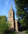
Todenroth, Protestant Church


Economy and Infrastructure
traffic
The federal highway 327 runs about two kilometers north of Todenroth and the federal highway 421 two kilometers east .
Todenroth is part of the Rhein-Mosel transport association . The Rheinhunsrückbus line 633 offers a connection to the next town, Kirchberg (Hunsrück) , on school days . The nearest train stations are Bullay on the Trier – Koblenz railway (25 kilometers away), Emmelshausen on the Boppard – Emmelshausen railway (28 kilometers) and Kirn on the Saarbrücken – Mainz railway (30 kilometers).
See also
Web links
- Todenroth parish
- Local community Todenroth on the website of the Kirchberg Association
- Literature about Todenroth in the Rhineland-Palatinate state bibliography
Individual evidence
- ↑ State Statistical Office of Rhineland-Palatinate - population status 2019, districts, communities, association communities ( help on this ).
- ^ The Regional Returning Officer RLP: City Council Election 2019 Todenroth. Retrieved October 7, 2019 .
- ^ The Regional Returning Officer RLP: direct elections 2019. see Kirchberg, Verbandsgemeinde, 35th line of results. Retrieved October 7, 2019 .
- ↑ Description of the coat of arms Todenroth

Bärenbach | Belg | Büchenbeuren | Dickenschied | Dill | Dillendorf | Gehlweiler | Gemünden | Rooster | Hedges | Heinzenbach | Henau | Hirschfeld (Hunsrück) | Kappel | Kirchberg (Hunsrück) | Kludenbach | Laufersweiler | Lautzenhausen | Lindenschied | Maitzborn | Metzenhausen | Low cost | Low ears | Niederweiler | Upper cost | Raversbeuren | Reckershausen | Rödelhausen | Rödern | Rohrbach | Conclusion | Blacks | Sohren | Sohrschied | Death Red | Unzenberg | Wahlenau | Womrath | Woppenroth | Würrich

Alterkülz | Altweidelbach | Argenthal | Badenhard | Bärenbach | Belg | Belgweiler | Bell (Hunsrück) | Beltheim | Benzweiler | Bergenhausen | Bulging | Bickenbach | Beavers | Birkheim | Boppard | Braunshorn | Bubach | Book | Büchenbeuren | Budenbach | Damscheid | Dichtelbach | Dickenschied | Dill | Dillendorf | Dommershausen | Dörth | Ellern (Hunsrück) | Emmelshausen | Erbach | Fronhofen | Gehlweiler | Gemünden | Gödenroth | Gondershausen | Rooster | Halsenbach | Hasselbach | House Bay | Hedges | Heinzenbach | Henau | Hirschfeld | Hollnich | Holzbach | Horn | Hungenroth | Kappel | Karbach | Kastellaun | Keidelheim | Kirchberg (Hunsrück) | Kisselbach | Klosterkumbd | Kludenbach | Korweiler | Kratzenburg | Külz (Hunsrück) | Kümbdchen | Lahr | Laubach | Laudert | Laufersweiler | Lautzenhausen | Leiningen | Liebshausen | Lindenschied | Linger Hahn | Maisborn | Maitzborn | Mastershausen | Mengiffer | Mermuth | Metzenhausen | Michelbach | Mörschbach | Mörsdorf | Morshausen | Mill path | Mother difference | Nannhausen | Neuerkirch | Ney | Low cost | Niederburg | Niederkumbd | Low ears | Niedert | Niederweiler | Norath | Upper cost | Oberwesel | Ohlweiler | Oppertshausen | Perscheid | Pfalzfeld | Pleizenhausen | Ravengiersburg | Raversbeuren | Rayanders | Reckershausen | Empire | Rheinböllen | Riegenroth | Riesweiler | Rödelhausen | Rödern | Rohrbach | Roth | Sankt Goar | Sargenroth | Conclusion | Schnorbach | Schönborn | Torrent | Blacks | Simmern / Hunsrück | Sohren | Sohrschied | Expense red | Steinbach | Thörlingen | Tiefenbach | Death Red | Uhler | Unzenberg | Urbar | Utzenhain | Wahlbach | Wahlenau | Wiebelsheim | Womrath | Woppenroth | Würrich | Wüschheim | Zilshausen