
Dichtelbach
| coat of arms | Germany map | |
|---|---|---|

|
Coordinates: 50 ° 1 ' N , 7 ° 42' E |
|
| Basic data | ||
| State : | Rhineland-Palatinate | |
| County : | Rhein-Hunsrück district | |
| Association municipality : | Simmern-Rheinböllen | |
| Height : | 403 m above sea level NHN | |
| Area : | 5.38 km 2 | |
| Residents: | 618 (Dec. 31, 2019) | |
| Population density : | 115 inhabitants per km 2 | |
| Postal code : | 55494 | |
| Area code : | 06764 | |
| License plate : | SIM, GOA | |
| Community key : | 07 1 40 027 | |
| Association administration address: | Am Markt 1 55494 Rheinböllen |
|
| Website : | ||
| Local Mayor : | Martin Huhn (acting) | |
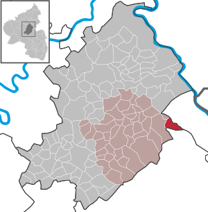
| Location of the local community Dichtelbach in the Rhein-Hunsrück district | ||
  |
||


Dichtelbach is a municipality in the Rhein-Hunsrück district in Rhineland-Palatinate . It belongs to the Simmern-Rheinböllen community .
geography
Dichtelbach is located in the eastern part of the Hunsrück , between the federal highway 61 and the Binger Forest . The village is on the old Roman road, the so-called Ausoniusstraße , which led from Trier to Bacharach . The place derives its name from the "Dichtelbach" which flows into the Guldenbach between Rheinböllen and Rheinböllerhütte .
The name is actually derived from Dadilebach , which means something like Feuerbach. It was called Feuerbach because of the many charcoal piles in the forest.
The Heidehof residential area also belongs to Dichtelbach.
history
Dichtelbach was first mentioned in a document in 996. The rulers were the dukes of Palatinate-Simmern and from 1673 the electors of the Palatinate . With the occupation of the Left Bank of the Rhine in 1794 by French revolutionary troops , the place became French, in 1815 it was assigned to the Kingdom of Prussia at the Congress of Vienna . Since 1946 the place has been part of the then newly formed state of Rhineland-Palatinate.
From 1986 to 1991 American Patriot missiles for anti-aircraft missiles were stationed on the Kandrich near Dichtelbach . A barrack in the forest and eight horseshoe-shaped protective walls on the Kandrich, where there are three wind turbines today, bear witness to this. In front of the Patriot anti-aircraft missiles, there was a radar station on the Kandrich, which was used to guide the Nike missiles , which were stationed on Grundlos-Wies until 1983 . At the end of the Cold War, the military facility on the Kandrich was given up, the barracks and the Bundeswehr mobilization base, built in 1992 on the Grundlos-Wies near Dichtelbach, followed by 2006.
- Population development
The development of the population of Dichtelbach, the values from 1871 to 1987 are based on censuses:
|
|
politics
Municipal council
The council in Dichtelbach consists of twelve council members, who in the local elections on May 26, 2019 in a majority vote were elected, and the honorary mayor as chairman.
mayor
The previous mayor, Martin Huhn, is currently continuing the official business on a provisional basis, as there was neither a candidate in the local elections on May 26, 2019, and the local council was unable to make an election due to a lack of applicants.
See also
Web links
- Internet presence of the community Dichtelbach
- Portrait of Dichtelbach near Hierzuland , SWR television
- Literature about Dichtelbach in the Rhineland-Palatinate State Bibliography }
Individual evidence
- ↑ State Statistical Office of Rhineland-Palatinate - population status 2019, districts, communities, association communities ( help on this ).
- ↑ State Statistical Office Rhineland-Palatinate (ed.): Official directory of the municipalities and parts of the municipality. Status: January 2018 [ Version 2020 is available. ] . S. 38 (PDF; 2.2 MB).
- ↑ State Statistical Office Rhineland-Palatinate - regional data
- ^ The Regional Returning Officer RLP: Municipal Council Election 2019 Dichtelbach. Retrieved October 3, 2019 .
- ↑ Local community Dichtelbach: The new local council introduces itself. August 28, 2019, accessed October 2, 2019 .

Alterkülz | Altweidelbach | Argenthal | Badenhard | Bärenbach | Belg | Belgweiler | Bell (Hunsrück) | Beltheim | Benzweiler | Bergenhausen | Bulging | Bickenbach | Beavers | Birkheim | Boppard | Braunshorn | Bubach | Book | Büchenbeuren | Budenbach | Damscheid | Dichtelbach | Dickenschied | Dill | Dillendorf | Dommershausen | Dörth | Ellern (Hunsrück) | Emmelshausen | Erbach | Fronhofen | Gehlweiler | Gemünden | Gödenroth | Gondershausen | Rooster | Halsenbach | Hasselbach | House Bay | Hedges | Heinzenbach | Henau | Hirschfeld | Hollnich | Holzbach | Horn | Hungenroth | Kappel | Karbach | Kastellaun | Keidelheim | Kirchberg (Hunsrück) | Kisselbach | Klosterkumbd | Kludenbach | Korweiler | Kratzenburg | Külz (Hunsrück) | Kümbdchen | Lahr | Laubach | Laudert | Laufersweiler | Lautzenhausen | Leiningen | Liebshausen | Lindenschied | Linger Hahn | Maisborn | Maitzborn | Mastershausen | Mengiffer | Mermuth | Metzenhausen | Michelbach | Mörschbach | Mörsdorf | Morshausen | Mill path | Mother difference | Nannhausen | Neuerkirch | Ney | Low cost | Niederburg | Niederkumbd | Low ears | Niedert | Niederweiler | Norath | Upper cost | Oberwesel | Ohlweiler | Oppertshausen | Perscheid | Pfalzfeld | Pleizenhausen | Ravengiersburg | Raversbeuren | Rayanders | Reckershausen | Empire | Rheinböllen | Riegenroth | Riesweiler | Rödelhausen | Rödern | Rohrbach | Roth | Sankt Goar | Sargenroth | Conclusion | Schnorbach | Schönborn | Torrent | Blacks | Simmern / Hunsrück | Sohren | Sohrschied | Expense red | Steinbach | Thörlingen | Tiefenbach | Death Red | Uhler | Unzenberg | Urbar | Utzenhain | Wahlbach | Wahlenau | Wiebelsheim | Womrath | Woppenroth | Würrich | Wüschheim | Zilshausen