
Klosterkumbd
| coat of arms | Germany map | |
|---|---|---|

|
Coordinates: 50 ° 2 ′ N , 7 ° 32 ′ E |
|
| Basic data | ||
| State : | Rhineland-Palatinate | |
| County : | Rhein-Hunsrück district | |
| Association municipality : | Simmern-Rheinböllen | |
| Height : | 403 m above sea level NHN | |
| Area : | 7.33 km 2 | |
| Residents: | 275 (Dec. 31, 2019) | |
| Population density : | 38 inhabitants per km 2 | |
| Postal code : | 55469 | |
| Area code : | 06761 | |
| License plate : | SIM, GOA | |
| Community key : | 07 1 40 070 | |
| Association administration address: | Brühlstrasse 2 55469 Simmern / Hunsrück |
|
| Website : | ||
| Local Mayor : | Klaus Nick | |
| Location of the local community Klosterkumbd in the Rhein-Hunsrück district | ||
  |
||

Klosterkumbd , official spelling until December 6, 1935: Klosterchumbd, is a municipality in the Rhein-Hunsrück district in Rhineland-Palatinate . It belongs to the community of Simmern-Rheinböllen and is located in the valley of the Kumbdbach, four kilometers northeast of the district town of Simmern .
Klosterkumbd also includes the living spaces Birkenhof , Binnenbergermühle , Forsthaus Klosterkumbd , Kloster and St. Georgenhausen .
history
The history of the place is determined by the former Cistercian monastery Kumbd , which was in the district of Kloster. It was founded in 1183 by Eberhard von Commeda ( Eberhard von Kumbd ) with the support and on the previous property of Heinrich von Dicka. In 1196 the Archbishop of Mainz Konrad von Wittelsbach confirmed the foundation. In 1566 the monastery was closed by the Count Palatine Georg von Simmern . In 1673 the place became part of the Electoral Palatinate . With the occupation of the left bank of the Rhine in 1794 by French revolutionary troops , the place became French, in 1815 it was assigned to the Kingdom of Prussia at the Congress of Vienna . Since 1946 the place has been part of the newly formed state of Rhineland-Palatinate.
politics
Municipal council
The council in Klosterkumbd consists of six council members, who in the local elections on May 26, 2019 in a majority vote were elected, and the honorary mayor as chairman.
mayor
The local mayor is Klaus Nick. In the local elections on May 26, 2019, he was confirmed in office with 93.33% of the votes.
Wind energy
The Klosterkumbd wind farm, which currently has six wind turbines, is located in a forest area northwest of the municipality .
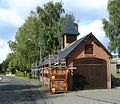
Culture and sights
- Views of Klosterkumbd

Klosterkumbd from the south-west

modern meeting house
historical bakery


Web links
- http://www.klosterkumbd.com
- Literature about Klosterkumbd in the Rhineland-Palatinate State Bibliography
Individual evidence
- ↑ State Statistical Office of Rhineland-Palatinate - population status 2019, districts, communities, association communities ( help on this ).
- ↑ Statistics of the German Reich, Volume 450: Official municipality directory for the German Reich, Part I, Berlin 1939; Page 267
- ↑ State Statistical Office Rhineland-Palatinate (ed.): Official directory of the municipalities and parts of the municipality. Status: January 2018 [ Version 2020 is available. ] . S. 39 (PDF; 2.2 MB).
- ^ The regional returning officer RLP: Municipal council election 2019 Klosterkumbd. Retrieved October 5, 2019 .
- ^ The Regional Returning Officer RLP: direct elections 2019. see Simmern-Rheinböllen, Verbandsgemeinde, 18th line of results. Retrieved October 5, 2019 .

Alterkülz | Altweidelbach | Argenthal | Badenhard | Bärenbach | Belg | Belgweiler | Bell (Hunsrück) | Beltheim | Benzweiler | Bergenhausen | Bulging | Bickenbach | Beavers | Birkheim | Boppard | Braunshorn | Bubach | Book | Büchenbeuren | Budenbach | Damscheid | Dichtelbach | Dickenschied | Dill | Dillendorf | Dommershausen | Dörth | Ellern (Hunsrück) | Emmelshausen | Erbach | Fronhofen | Gehlweiler | Gemünden | Gödenroth | Gondershausen | Rooster | Halsenbach | Hasselbach | House Bay | Hedges | Heinzenbach | Henau | Hirschfeld | Hollnich | Holzbach | Horn | Hungenroth | Kappel | Karbach | Kastellaun | Keidelheim | Kirchberg (Hunsrück) | Kisselbach | Klosterkumbd | Kludenbach | Korweiler | Kratzenburg | Külz (Hunsrück) | Kümbdchen | Lahr | Laubach | Laudert | Laufersweiler | Lautzenhausen | Leiningen | Liebshausen | Lindenschied | Linger Hahn | Maisborn | Maitzborn | Mastershausen | Mengiffer | Mermuth | Metzenhausen | Michelbach | Mörschbach | Mörsdorf | Morshausen | Mill path | Mother difference | Nannhausen | Neuerkirch | Ney | Low cost | Niederburg | Niederkumbd | Low ears | Niedert | Niederweiler | Norath | Upper cost | Oberwesel | Ohlweiler | Oppertshausen | Perscheid | Pfalzfeld | Pleizenhausen | Ravengiersburg | Raversbeuren | Rayanders | Reckershausen | Empire | Rheinböllen | Riegenroth | Riesweiler | Rödelhausen | Rödern | Rohrbach | Roth | Sankt Goar | Sargenroth | Conclusion | Schnorbach | Schönborn | Torrent | Blacks | Simmern / Hunsrück | Sohren | Sohrschied | Expense red | Steinbach | Thörlingen | Tiefenbach | Death Red | Uhler | Unzenberg | Urbar | Utzenhain | Wahlbach | Wahlenau | Wiebelsheim | Womrath | Woppenroth | Würrich | Wüschheim | Zilshausen