
Mill path
| coat of arms | Germany map | |
|---|---|---|

|
Coordinates: 50 ° 7 ' N , 7 ° 33' E |
|
| Basic data | ||
| State : | Rhineland-Palatinate | |
| County : | Rhein-Hunsrück district | |
| Association municipality : | Hunsrück-Middle Rhine | |
| Height : | 440 m above sea level NHN | |
| Area : | 1.39 km 2 | |
| Residents: | 70 (Dec 31, 2019) | |
| Population density : | 50 inhabitants per km 2 | |
| Postal code : | 56291 | |
| Area code : | 06746 | |
| License plate : | SIM, GOA | |
| Community key : | 07 1 40 098 | |
| Association administration address: | Rathausstrasse 1 56281 Emmelshausen |
|
| Website : | ||
| Local Mayor : | Florian Kneip | |
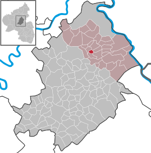
| Location of the local community Mühlpfad in the Rhein-Hunsrück district | ||
  |
||


Mühlpfad is the smallest municipality in the Rhein-Hunsrück district in Rhineland-Palatinate . It belongs to the Hunsrück-Mittelrhein community .
geography
Mühlpfad is located in the eastern part of the Hunsrück, south of Emmelshausen .
politics
Municipal council
The council in Mühlpfad consists of six members, in the local elections on May 26, 2019 in a majority vote were elected, and the honorary mayor as chairman.
mayor
Local mayor is Florian Kneip. In the local elections on May 26, 2019, he was confirmed in his office with 85.11% of the vote.
coat of arms
Blazon : “Divided by a green bar, at the top a blue millstone in silver , accompanied on the right and left by a red vertical mill iron ; below in gold a blue crowned, armored and tongued, looking red lion. "
traffic
Mühlpfad is close to the Hunsrückhöhenstraße and the federal motorway 61 .
Web links
Individual evidence
- ↑ State Statistical Office of Rhineland-Palatinate - population status 2019, districts, communities, association communities ( help on this ).
- ↑ The Regional Returning Officer RLP: Municipal Council Election 2019 Mühlpfad. Retrieved October 6, 2019 .
- ^ The Regional Returning Officer RLP: direct elections 2019. see Hunsrück-Mittelrhein, Verbandsgemeinde, 19th result line. Retrieved October 6, 2019 .

Alterkülz | Altweidelbach | Argenthal | Badenhard | Bärenbach | Belg | Belgweiler | Bell (Hunsrück) | Beltheim | Benzweiler | Bergenhausen | Bulging | Bickenbach | Beavers | Birkheim | Boppard | Braunshorn | Bubach | Book | Büchenbeuren | Budenbach | Damscheid | Dichtelbach | Dickenschied | Dill | Dillendorf | Dommershausen | Dörth | Ellern (Hunsrück) | Emmelshausen | Erbach | Fronhofen | Gehlweiler | Gemünden | Gödenroth | Gondershausen | Rooster | Halsenbach | Hasselbach | House Bay | Hedges | Heinzenbach | Henau | Hirschfeld | Hollnich | Holzbach | Horn | Hungenroth | Kappel | Karbach | Kastellaun | Keidelheim | Kirchberg (Hunsrück) | Kisselbach | Klosterkumbd | Kludenbach | Korweiler | Kratzenburg | Külz (Hunsrück) | Kümbdchen | Lahr | Laubach | Laudert | Laufersweiler | Lautzenhausen | Leiningen | Liebshausen | Lindenschied | Linger Hahn | Maisborn | Maitzborn | Mastershausen | Mengiffer | Mermuth | Metzenhausen | Michelbach | Mörschbach | Mörsdorf | Morshausen | Mill path | Mother difference | Nannhausen | Neuerkirch | Ney | Low cost | Niederburg | Niederkumbd | Low ears | Niedert | Niederweiler | Norath | Upper cost | Oberwesel | Ohlweiler | Oppertshausen | Perscheid | Pfalzfeld | Pleizenhausen | Ravengiersburg | Raversbeuren | Rayanders | Reckershausen | Empire | Rheinböllen | Riegenroth | Riesweiler | Rödelhausen | Rödern | Rohrbach | Roth | Sankt Goar | Sargenroth | Conclusion | Schnorbach | Schönborn | Torrent | Blacks | Simmern / Hunsrück | Sohren | Sohrschied | Expense red | Steinbach | Thörlingen | Tiefenbach | Death Red | Uhler | Unzenberg | Urbar | Utzenhain | Wahlbach | Wahlenau | Wiebelsheim | Womrath | Woppenroth | Würrich | Wüschheim | Zilshausen