
Birkheim
| coat of arms | Germany map | |
|---|---|---|

|
Coordinates: 50 ° 7 ' N , 7 ° 37' E |
|
| Basic data | ||
| State : | Rhineland-Palatinate | |
| County : | Rhein-Hunsrück district | |
| Association municipality : | Hunsrück-Middle Rhine | |
| Height : | 463 m above sea level NHN | |
| Area : | 2.3 km 2 | |
| Residents: | 148 (Dec. 31, 2019) | |
| Population density : | 64 inhabitants per km 2 | |
| Postal code : | 56291 | |
| Area code : | 06746 | |
| License plate : | SIM, GOA | |
| Community key : | 07 1 40 016 | |
| LOCODE : | DE 3BN | |
| Address of the municipal administration: |
Rathausstrasse 1 56281 Emmelshausen |
|
| Website : | ||
| Local Mayor : | Reiner Retz | |
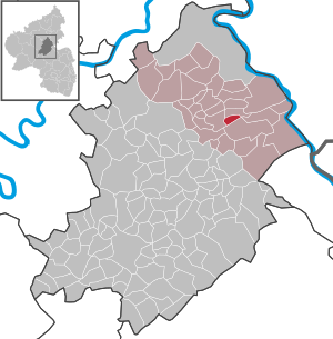
| Location of the local community Birkheim in the Rhein-Hunsrück district | ||
  |
||


Birkheim is a municipality in the Rhein-Hunsrück district in Rhineland-Palatinate . It belongs to the Hunsrück-Mittelrhein community .
Geographical location
Birkheim is located in the east of the Hunsrück , between the Middle Rhine Valley and the federal highway 61 .
history
The place was first mentioned in 1310 as Bircheym and was under the sovereignty of Kurtrier until the end of the 18th century .
With the annexation of the left bank of the Rhine (1794) by French revolutionary troops , the place became French . From 1798 to 1814 Birkheim belonged to the canton of Sankt Goar in the Rhine-Moselle department and from 1800 to the Mairie Sankt Goar . Due to the agreements made at the Congress of Vienna (1815), the region was assigned to the Kingdom of Prussia . Under the Prussian administration, Birkheim came to the mayor's office Pfalzfeld in the district of Sankt Goar and to the administrative district of Koblenz in the province of Grand Duchy of Lower Rhine (from 1822 Rhine province ). After the First World War temporarily occupied by the French , the place has been part of the then newly formed state of Rhineland-Palatinate since 1946 . The local community of Birkheim has been part of the Emmelshausen community since 1970 .
- Statistics on population development
The development of the population of the municipality of Birkheim, the values from 1871 to 1987 are based on censuses:
|
|
politics
Municipal council
The municipal council in Birkheim consists of six council members, who were elected by a majority vote in the local elections on May 26, 2019 , and the honorary local mayor as chairman.
mayor
The local mayor is Reiner Retz. In the local elections on May 26, 2019, he was confirmed in his office with 93.10% of the vote.
coat of arms
|
|
Blazon : "Shield in silver divided by a blue oblique left-hand wave beam, a red cross in front, a blue oblique right-hand wave beam in the back, a black water wheel below, a green birch leaf above." |
See also
literature
- Literature about Birkheim in the Rhineland-Palatinate State Bibliography
Web links
Individual evidence
- ↑ State Statistical Office of Rhineland-Palatinate - population status 2019, districts, communities, association communities ( help on this ).
- ↑ State Statistical Office Rhineland-Palatinate - regional data
- ^ The Regional Returning Officer RLP: City Council Election 2019 Birkheim. Retrieved October 5, 2019 .
- ^ The Regional Returning Officer RLP: direct elections 2019. see Hunsrück-Mittelrhein, Verbandsgemeinde, fourth line of results. Retrieved October 5, 2019 .

Alterkülz | Altweidelbach | Argenthal | Badenhard | Bärenbach | Belg | Belgweiler | Bell (Hunsrück) | Beltheim | Benzweiler | Bergenhausen | Bulging | Bickenbach | Beavers | Birkheim | Boppard | Braunshorn | Bubach | Book | Büchenbeuren | Budenbach | Damscheid | Dichtelbach | Dickenschied | Dill | Dillendorf | Dommershausen | Dörth | Ellern (Hunsrück) | Emmelshausen | Erbach | Fronhofen | Gehlweiler | Gemünden | Gödenroth | Gondershausen | Rooster | Halsenbach | Hasselbach | House Bay | Hedges | Heinzenbach | Henau | Hirschfeld | Hollnich | Holzbach | Horn | Hungenroth | Kappel | Karbach | Kastellaun | Keidelheim | Kirchberg (Hunsrück) | Kisselbach | Klosterkumbd | Kludenbach | Korweiler | Kratzenburg | Külz (Hunsrück) | Kümbdchen | Lahr | Laubach | Laudert | Laufersweiler | Lautzenhausen | Leiningen | Liebshausen | Lindenschied | Linger Hahn | Maisborn | Maitzborn | Mastershausen | Mengiffer | Mermuth | Metzenhausen | Michelbach | Mörschbach | Mörsdorf | Morshausen | Mill path | Mother difference | Nannhausen | Neuerkirch | Ney | Low cost | Niederburg | Niederkumbd | Low ears | Niedert | Niederweiler | Norath | Upper cost | Oberwesel | Ohlweiler | Oppertshausen | Perscheid | Pfalzfeld | Pleizenhausen | Ravengiersburg | Raversbeuren | Rayanders | Reckershausen | Empire | Rheinböllen | Riegenroth | Riesweiler | Rödelhausen | Rödern | Rohrbach | Roth | Sankt Goar | Sargenroth | Conclusion | Schnorbach | Schönborn | Torrent | Blacks | Simmern / Hunsrück | Sohren | Sohrschied | Expense red | Steinbach | Thörlingen | Tiefenbach | Death Red | Uhler | Unzenberg | Urbar | Utzenhain | Wahlbach | Wahlenau | Wiebelsheim | Womrath | Woppenroth | Würrich | Wüschheim | Zilshausen