
Belg
| coat of arms | Germany map | |
|---|---|---|

|
Coordinates: 49 ° 59 ' N , 7 ° 19' E |
|
| Basic data | ||
| State : | Rhineland-Palatinate | |
| County : | Rhein-Hunsrück district | |
| Association municipality : | Kirchberg (Hunsrück) | |
| Height : | 440 m above sea level NHN | |
| Area : | 4.79 km 2 | |
| Residents: | 112 (Dec. 31, 2019) | |
| Population density : | 23 inhabitants per km 2 | |
| Postal code : | 56858 | |
| Area code : | 06543 | |
| License plate : | SIM, GOA | |
| Community key : | 07 1 40 007 | |
| LOCODE : | DE B4K | |
| Association administration address: | Marktplatz 5 55481 Kirchberg (Hunsrück) |
|
| Website : | ||
| Local Mayor : | Karl-Heinz Schneider | |
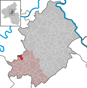
| Location of the local community Belg in the Rhein-Hunsrück district | ||
  |
||


Belg is a municipality in the Rhein-Hunsrück district in Rhineland-Palatinate . It belongs to the Kirchberg (Hunsrück) community .
geography
Belg is centrally located in the Hunsrück , directly on the Hunsrückhöhenstraße B 327 .
history
The first written mention comes from the year 1295.
Belg belonged to the late 18th century country wonderfully for Front County of Sponheim , the last in possession of the Margrave of Baden was. Within the Kirchberg office , Belg was the capital of an administrative and judicial district called care . The villages of Altlay , Kappel , Rödelhausen and Würrich also belonged to the care Belg .
With the occupation of the Left Bank of the Rhine in 1794 by French revolutionary troops , the place became French , from 1798 to 1814 it belonged to the canton of Kirchberg , which was assigned to the Rhine-Moselle department . At the Congress of Vienna (1815) the region was assigned to the Kingdom of Prussia . Under the Prussian administration, Belg was subordinate to the Mayor's office in Sohren in the Zell district from 1816 and belonged to the Rhine Province from 1822 until the end of the Second World War . Since 1946 the place has been part of the then newly formed state of Rhineland-Palatinate and has belonged to the Kirchberg community since 1970 .
- Statistics on population development
The development of the population of the municipality of Belg, the values from 1871 to 1987 are based on censuses:
|
|
politics
Municipal council
The council in Belg consists of six council members, who in the local elections on May 26, 2019 in a majority vote were elected, and the honorary mayor as chairman.
mayor
The local mayor of Belg is Karl-Heinz Schneider. In the local elections on May 26, 2019, no candidate ran, he was re-elected by the local council.
coat of arms
|
|
Blazon : "Split on the left, two diagonally crossed silver hammers in green at the front, covered with a silver ear, sheathed in gold and blue at the back." |
| Justification of the coat of arms: The ear of wheat symbolizes agriculture in the municipality, the hammers refer to the earlier slate mining in the district . The green color indicates forest ownership. The chess in the back half of the shield reminds of the former affiliation to the Vordere Grafschaft Sponheim . |
Web links
- Information on Belg from the Kirchberg Association
- Belg in the television show Hierzuland
- Literature about Belg in the Rhineland-Palatinate State Bibliography
Individual evidence
- ↑ State Statistical Office of Rhineland-Palatinate - population status 2019, districts, communities, association communities ( help on this ).
- ↑ State Statistical Office Rhineland-Palatinate - regional data
- ^ The Regional Returning Officer RLP: Municipal Council Election 2019 Belg. Retrieved October 8, 2019 .
- ^ The regional returning officer RLP: direct elections 2019. see Kirchberg, Verbandsgemeinde, second line of results. Retrieved October 8, 2019 .
- ^ Verbandsgemeinde Kirchberg: Ortsgemeinde Belg. Local council. Retrieved October 8, 2019 .

Alterkülz | Altweidelbach | Argenthal | Badenhard | Bärenbach | Belg | Belgweiler | Bell (Hunsrück) | Beltheim | Benzweiler | Bergenhausen | Bulging | Bickenbach | Beavers | Birkheim | Boppard | Braunshorn | Bubach | Book | Büchenbeuren | Budenbach | Damscheid | Dichtelbach | Dickenschied | Dill | Dillendorf | Dommershausen | Dörth | Ellern (Hunsrück) | Emmelshausen | Erbach | Fronhofen | Gehlweiler | Gemünden | Gödenroth | Gondershausen | Rooster | Halsenbach | Hasselbach | House Bay | Hedges | Heinzenbach | Henau | Hirschfeld | Hollnich | Holzbach | Horn | Hungenroth | Kappel | Karbach | Kastellaun | Keidelheim | Kirchberg (Hunsrück) | Kisselbach | Klosterkumbd | Kludenbach | Korweiler | Kratzenburg | Külz (Hunsrück) | Kümbdchen | Lahr | Laubach | Laudert | Laufersweiler | Lautzenhausen | Leiningen | Liebshausen | Lindenschied | Linger Hahn | Maisborn | Maitzborn | Mastershausen | Mengiffer | Mermuth | Metzenhausen | Michelbach | Mörschbach | Mörsdorf | Morshausen | Mill path | Mother difference | Nannhausen | Neuerkirch | Ney | Low cost | Niederburg | Niederkumbd | Low ears | Niedert | Niederweiler | Norath | Upper cost | Oberwesel | Ohlweiler | Oppertshausen | Perscheid | Pfalzfeld | Pleizenhausen | Ravengiersburg | Raversbeuren | Rayanders | Reckershausen | Empire | Rheinböllen | Riegenroth | Riesweiler | Rödelhausen | Rödern | Rohrbach | Roth | Sankt Goar | Sargenroth | Conclusion | Schnorbach | Schönborn | Torrent | Blacks | Simmern / Hunsrück | Sohren | Sohrschied | Expense red | Steinbach | Thörlingen | Tiefenbach | Death Red | Uhler | Unzenberg | Urbar | Utzenhain | Wahlbach | Wahlenau | Wiebelsheim | Womrath | Woppenroth | Würrich | Wüschheim | Zilshausen