
Schwall (Rhein-Hunsrück District)
| coat of arms | Germany map | |
|---|---|---|

|
Coordinates: 50 ° 9 ′ N , 7 ° 33 ′ E |
|
| Basic data | ||
| State : | Rhineland-Palatinate | |
| County : | Rhein-Hunsrück district | |
| Association municipality : | Hunsrück-Middle Rhine | |
| Height : | 420 m above sea level NHN | |
| Area : | 1.77 km 2 | |
| Residents: | 312 (Dec. 31, 2019) | |
| Population density : | 176 inhabitants per km 2 | |
| Postal code : | 56281 | |
| Area code : | 06747 | |
| License plate : | SIM, GOA | |
| Community key : | 07 1 40 140 | |
| Association administration address: | Rathausstrasse 1 56281 Emmelshausen |
|
| Website : | ||
| Local Mayor : | Hermann-Josef Wilhelm | |
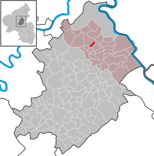
| Location of the local community Schwall in the Rhein-Hunsrück district | ||
  |
||

Schwall is a municipality in the Rhein-Hunsrück district in Rhineland-Palatinate . It belongs to the Hunsrück-Mittelrhein community .
geography
The community Schwall is located south of Emmelshausen on the Hunsrück plateau . The Hunsrückhöhenstrasse runs east of the village .
The Layenmühle and Schwallermühle residential areas also belong to Schwall .
history
The place was first mentioned in a document in 1300 under the name "Swalle".
The lords of Eltz were landlords and court lords in Leinigen and Schwall in the 16th century . later it belonged to the rule of the Counts von der Leyen . With the occupation of the Left Bank of the Rhine in 1794 by French revolutionary troops , the place became French, in 1815 it was assigned to the Kingdom of Prussia at the Congress of Vienna . After the First World War temporarily occupied by the French , the place has been part of the then newly formed state of Rhineland-Palatinate since 1946.
- Statistics on population development
The development of the population of the community Schwall, the values from 1871 to 1987 are based on censuses:
|
|
politics
Municipal council
The local council in Schwall consists of eight council members, who were elected by a majority vote in the local elections on May 26, 2019 , and the honorary local mayor as chairman.
mayor
The local mayor is Hermann-Josef Wilhelm. In the local elections on May 26, 2019, he was confirmed in office with 70.35% of the votes.
coat of arms
|
|
Blazon : "In a divided shield above in gold a red plow, below a silver pole in blue." |
| Foundation of the coat of arms: The upper half of the shield relates to the landscape structure of the municipality. The colors red and gold refer to the Lords of Eltz, who owned the village of Schwall in the 16th century. The lower half of the shield refers to the former belonging to the rule of the Counts von der Leyen. |
See also
Web links
- Literature about flood in the Rhineland-Palatinate state bibliography
Individual evidence
- ↑ State Statistical Office of Rhineland-Palatinate - population status 2019, districts, communities, association communities ( help on this ).
- ↑ State Statistical Office Rhineland-Palatinate (ed.): Official directory of the municipalities and parts of the municipality. Status: January 2018 [ Version 2020 is available. ] . S. 36 (PDF; 2.2 MB).
- ↑ Schwall in the historical local dictionary ( regionalgeschichte.net ; PDF file; 27 kB)
- ↑ State Statistical Office Rhineland-Palatinate - regional data
- ^ The Regional Returning Officer RLP: City Council Election 2019 Schwall. Retrieved October 6, 2019 .
- ^ The Regional Returning Officer RLP: direct elections 2019. see Hunsrück-Mittelrhein, Verbandsgemeinde, 34th line of results. Retrieved October 6, 2019 .

Alterkülz | Altweidelbach | Argenthal | Badenhard | Bärenbach | Belg | Belgweiler | Bell (Hunsrück) | Beltheim | Benzweiler | Bergenhausen | Bulging | Bickenbach | Beavers | Birkheim | Boppard | Braunshorn | Bubach | Book | Büchenbeuren | Budenbach | Damscheid | Dichtelbach | Dickenschied | Dill | Dillendorf | Dommershausen | Dörth | Ellern (Hunsrück) | Emmelshausen | Erbach | Fronhofen | Gehlweiler | Gemünden | Gödenroth | Gondershausen | Rooster | Halsenbach | Hasselbach | House Bay | Hedges | Heinzenbach | Henau | Hirschfeld | Hollnich | Holzbach | Horn | Hungenroth | Kappel | Karbach | Kastellaun | Keidelheim | Kirchberg (Hunsrück) | Kisselbach | Klosterkumbd | Kludenbach | Korweiler | Kratzenburg | Külz (Hunsrück) | Kümbdchen | Lahr | Laubach | Laudert | Laufersweiler | Lautzenhausen | Leiningen | Liebshausen | Lindenschied | Linger Hahn | Maisborn | Maitzborn | Mastershausen | Mengiffer | Mermuth | Metzenhausen | Michelbach | Mörschbach | Mörsdorf | Morshausen | Mill path | Mother difference | Nannhausen | Neuerkirch | Ney | Low cost | Niederburg | Niederkumbd | Low ears | Niedert | Niederweiler | Norath | Upper cost | Oberwesel | Ohlweiler | Oppertshausen | Perscheid | Pfalzfeld | Pleizenhausen | Ravengiersburg | Raversbeuren | Rayanders | Reckershausen | Empire | Rheinböllen | Riegenroth | Riesweiler | Rödelhausen | Rödern | Rohrbach | Roth | Sankt Goar | Sargenroth | Conclusion | Schnorbach | Schönborn | Torrent | Blacks | Simmern / Hunsrück | Sohren | Sohrschied | Expense red | Steinbach | Thörlingen | Tiefenbach | Death Red | Uhler | Unzenberg | Urbar | Utzenhain | Wahlbach | Wahlenau | Wiebelsheim | Womrath | Woppenroth | Würrich | Wüschheim | Zilshausen