
Oberwesel
| coat of arms | Germany map | |
|---|---|---|

|
Coordinates: 50 ° 7 ' N , 7 ° 43' E |
|
| Basic data | ||
| State : | Rhineland-Palatinate | |
| County : | Rhein-Hunsrück district | |
| Association municipality : | Hunsrück-Middle Rhine | |
| Height : | 75 m above sea level NHN | |
| Area : | 18.08 km 2 | |
| Residents: | 2781 (Dec. 31, 2019) | |
| Population density : | 154 inhabitants per km 2 | |
| Postal code : | 55430 | |
| Area code : | 06744 | |
| License plate : | SIM, GOA | |
| Community key : | 07 1 40 112 | |
| LOCODE : | DE OEE | |
| City structure: | 4 districts | |
City administration address : |
Rathausstrasse 3 55430 Oberwesel |
|
| Website : | ||
| City Mayor : | Marius Stiehl ( CDU ) | |
| Location of the city of Oberwesel in the Rhein-Hunsrück district | ||
  |
||


Oberwesel is a city on the Middle Rhine . It is located in Rhineland-Palatinate in the Rhein-Hunsrück district . The city belongs to the Hunsrück-Mittelrhein community and is one of the two administrative centers. Oberwesel is a state-approved tourist destination and designated as a basic center according to state planning .
In the high and late Middle Ages , Oberwesel was an independent imperial city in the Holy Roman Empire , which is reflected in the city's coat of arms.
geography
location

The city is located on the left bank of the Rhine in the UNESCO World Heritage Upper Middle Rhine Valley at Rhine kilometer 550 between the neighboring communities of Sankt Goar and Bacharach at the foot of the Schönburg .
City structure
In addition to the core city, the city consists of the districts Engehöll , Dellhofen and Langscheid , each of which has its own local councilor and local council.
geomorphology
The Rhine, which his closest here between Kaub and St. Goar canyon-like forming part of the valley, bends north of Oberwesel to the east in the Rhenish painting of the Rhenish Massif and forms here an undercut slope which, facing south-southeast, with its steep slopes and a Lösslehmauflage offers the best conditions for viticulture on the slate subsoil of the Oelsberg . The slopes directly by the city are oriented to the northeast and over-section, so that viticulture is only possible in the south exposed side valleys of the city. The city itself moves directly to the edge of the lower terrace of the river, which has cut into this about 13 m. The B 9 is already flooded at a water level of 5.80 m, the Kaub gauge . (→ Rhine flood )
climate
The annual precipitation is 604 mm. It is in the lower quarter of the values recorded in Germany. Lower values are registered at 22% of the German Weather Service's measuring stations . The driest month is February, with the most rainfall in June. In June there is 1.6 times more rainfall than in February. Precipitation varies only minimally and is extremely evenly distributed over the year. Lower seasonal fluctuations are recorded at only 1% of the measuring stations .
history
Middle Bronze and La Tène Period

As with many cities in the Middle Rhine region, the origins of these places and their names probably go back to a Celtic settlement. Even in pre-Christian times, today's municipality of Oberwesel was a preferred settlement on this section of the Rhine. The early place name "Vosavia" is said to date from around 50 BC. And is traced back to the people of the Celts, who had settled large parts of Western Europe since the third century BC. The traces that these early settlers left in Oberwesel are the numerous finds that were recovered from barrows in the Oberwesel Forest. Tribes of the Treveri people settled on the Moselle , on the heights of the Eifel and Hunsrück as well as on the narrow strips of the Rhine floodplains, also in the area of today's town of Oberwesel, of whose rich fishing grounds ( salmon fish ) the Romans later reported. They also found a wooded hinterland there for hunting, so that they did not have to move on, as their food seemed to be continuously secured on site. In addition, in the very sparsely populated region, the Rhine River offered an easy-to-use means of traffic and transport until the later emergence of Roman military roads .
Station on the Roman military road

Shortly before the turn of the millennium (13/12 BC), the areas on the left bank of the Rhine fell to the Roman conquerors. In the course of securing these areas, the Romans set up military camps, next to which places or even cities developed over time. At the time of Drusus (around 12th BC) a military station now called "Vosolvia" was built from Vosavia on the important Roman Rhine Valley Road between Mogontiacum (Mainz) and Confluentes (Koblenz) along the Rhine. This early name of the city is also shown on the Peutinger tablet , a replica of a Roman road map, as Vosavia.
On the Hard Oberwesels, in the district of today's Dellhofen district mentioned for the first time in 1307 , ancient masonry was torn down with a plow during field work, which also revealed a consecration stone . The stone of "Ibliomarus" - possibly a name of Celtic origin - dated to the time AD 100, was dedicated to Mercury and Maiae . The first reliable archaeological evidence of a Roman settlement in Oberwesel could not be provided until 2008. In an excavation at Schaarplatz, the archeology association ARRATA eV was able to discover rubbish pits from Roman times. Late Roman graves with additions, including bronze fittings from military belts, were known earlier and can be taken as evidence of a fort .
This and other finds, including glassware and coins recovered from a plot of land at Mainzer Straße 6, are exhibited in the city museum, for example specimens of the Sesterz , As or various Antoniniani , an ancient Roman silver coin that was produced under Emperor Caracalla (211-217) around 214 AD was introduced as the official currency.
Franconian time
After the fall of the Limes and the withdrawal of the Roman border troops, Franks took the abandoned areas, initially settled in villages or individual farms and lived as peasant warriors. There was plenty of abandoned land, since the number of people on the Middle Rhine had also decreased considerably during the migration period . After a certain period of consolidation, an extensive Franconian-royal fiscal district was formed, which presumably stretched between the southern borders of the Four Valley area around Bacharach and the northern border of Oberhirzenach , located downstream from Oberwesel , whose administration was ultimately headed by a "King". The former Boppard fort may have served as the royal court (or Merovingian royal seat) . (→ Boppard Empire )

An epoch with a clear improvement in the climate between the 9th and 14th centuries, a period known today as the Medieval Warm Period, then also led to an increase in the population, as the higher temperatures led to better yields and thus more people could be supplied with sufficient food . Another improvement came after Emperor Charlemagne had issued regulations to introduce three-field farming in the empire . Another royal court would later determine the fortunes of the Oberwesel family over a long period of time. There were also families of the Franconian upper class, those of the Konradines and Liudolfinger , from whose ranks the last king of the East Franks had emerged. Under Emperor Otto I, the Wesel estate went to the Archbishopric of Magdeburg in 966 .
Ottonian time
Shortly after the Hofgut (Ober) Wesel - referred to in the documents as "curtem Weslia" - with all its accessories as crown land to the Saxon King , Otto gave it to the monastery of St. Mauritius in Magdeburg , which was subordinate to the later Archbishopric of Magdeburg . It is still unclear whether this donation included all properties in "Weslia". The lists in the deed of donation, which meticulously named all individual items, gave the researchers indications of how self-sufficient the large estates of the time were. Listed were serfs, buildings, vineyards, meadows and pastures, forests, standing and flowing waters, rights relating to fishing and bird trapping , mills, and cultivated land and fallow land. In addition to the estate, which is explained in more detail here, there were other scattered courtyards that grew over time with newly built houses and together formed three core areas. These were the middle area with the royal farmyard in today's market district, the southern area (Kirchhausen) around the later Liebfrauenkirche and the northwestern core around the Martinskirche. The Museum an Strom in Bingen shows a model of these early settlement cores. These settlements were later merged to form the city of Wesel. In 1166 Friedrich I. (Barbarossa) acquired (the Hofgut Ober) Wesel and the hill castle Schönburg , which was built in the meantime and which was first mentioned in 1149 as owned by the Count Palatine Hermann von Stahleck .
First places of worship and convents
Magdeburg own church Mauritius
_am_%C3%A4u%C3%9Feren_Hochchor.jpg)

For the Magdeburg time, the Count of the Einrichgau , Ludwig III. von Arnstein , who owned the bailiff's rights and the patronage rights over the early Oberwesel churches. These rights were later passed to the Isenburger or to their branches of Kempenich and Arenfels . Since the Magdeburg lords owned a considerable part of the Wesel property, it is assumed that they also built a small chapel or church. This own church is said to have been named Mauritius after the patron of the Archbishopric Magdeburg . The market cross is intended to remind the city of their location.
Predecessor of the Liebfrauenkirche
A Marienkirche in the early Oberwesel was mentioned for the first time in 1213 and again in 1219 in documents of the "Wesel" burgrave Otto von Schönburg (in a different source than von Schonenburg and the name "ministerialis regis", so royal court official), in which the pleban Peter this Church (Petrus sacerdos plebanus ecclesie s. Marie), and a chaplain was also mentioned in the document of 1219. Nothing is known about this early church; However, it is believed that two octagonal columns on the stairways of the rood screen of today's parish church, built in the 14th century, could have come from this first St. Mary's Church. According to this, this 13th century church would have stood in the ring of the stairway to the Schönburg, on the edge of the later monastery area.
Predecessor of the Martinskirche
A forerunner of today's St. Martin Church, built on the highest location in the city, was first mentioned in 1219, like the Church of Our Lady. How long it lasted is not known, but with the completion of today's church it will have become obsolete . The start of construction is dated to the first half of the 14th century, a complete completion took place at longer intervals. According to a dendrochronological study, a tie rod on the top floor of the tower could be dated to the period after 1435. Apart from an early choir, the north aisle - a south aisle was not built - was not completed until the 16th century.
All Saints Monastery
._%C3%84btissin_des_ehem._Allerheiligenklosters_Oberwesel.jpg)
In the 19th century there was a legend that there was already a convent founded by women in Oberwesel in the 8th century . The statements attributed to Johann Christian von Stramberg , who was born in Koblenz in 1785, supported the thesis that the monk Willibrord, who was missionary in the Rhineland, founded a monastery in "Vasavia". According to the current state of research, however, such a foundation cannot be assumed. An exact year of foundation of the first convent in Oberwesel (around 1227 to 1236) is not documented. However, documents from the former mother monastery of the Premonstratensians in the Arnstein an der Lahn monastery show that the Allerheiligen monastery, which was relocated below the Martinsberg in the Niederbachtal ( extra muros ) around 1260 , was initially a convent run by Premonstratensian women, which was founded by Arnstein, or that the nuns had joined the Arnstein Abbey. In the Arnsteiner Nekrolog there were memories of three Oberwesel conventuals whose life data indirectly corroborate the founding period. The relocation of the monastery to a location remote from the city in the Niederbachtal was possibly a consequence of converting to the order of the Cistercian women and thus complied with the requirements of the rules of Cîteaux .
Minorite Monastery

Another branch of the order was probably initiated by the ministerials of Schönburg. So-called Friars Minor came to Oberwesel at their request . They were sent brothers from the branch of the Franciscan conventuals , founded in Trier in 1233 , who set up a new convent of their order in Oberwesel in 1246. In the later, very extensive monastery complex, the brothers began building a small, Gothic- style church in 1280 . As co-founders, the gentlemen von Schönburg had a burial crypt in it, as did the “Liebfrauen” collegiate church. In 1262 the convent already consisted of six members, headed by a Guardian . Because of the responsibilities in pastoral care, there was friction between the Minorites and the two collegiate churches in the first few years, which was ultimately settled by the Schönburgers - they were the patrons of all three institutions. The monks were popular with the people, probably also because of their modesty and willingness to help the poor and the sick. Around 1270 the Minorites founded a brotherhood of the Holy Spirit, as it emerged as a social institution in many cities of the empire. The name of the brotherhood was later also given to a first Oberwesel hospital, the chapel of which will be discussed later.
Fortification of the core city
In the period between the years 1220 and 1250, the fortification of the core city was carried out in parallel with the work on new sacred buildings. This was done through a first walling of the settlement to the right of the Oberbach (today canalised under Schaarplatz) and to the left of the Niederbach (largely still flows open), including the Martinskirche in the north-west of the city. The construction of this not yet very high protective wall - later the settlement in Niederbachtal and Kirchhausen was walled with the Liebfrauenkirche - can be seen in connection with the end of the Magdeburg rule (around 1220) and the liberation process of the city, which until then was under the bailiff 's law Lords of Schönburg had confessed and aspired to the status of imperial immediacy. The construction of the wall was accompanied by the expansion of roads and the creation of a central market square.

Steingasse tower, shell tower facing the city around 1243

Hospital tower, shell tower facing the city

Western city wall and moat

City wall and cowherd tower on the Michelfeld
Ox tower
.jpg)
.jpg)

.jpg)

The fortification work probably began on the Rhine side, as there were natural moats on both sides of the city center and in the west the protection of the mountainside over the Michelfeld was initially considered sufficient. After an all-round manufacturing process of the walling, which was made from local slate, the next construction phase was started, which provided for the elevation of the city wall and the construction of the first shell towers characteristic of this time. In addition to some of the first weir cores, four defense towers were initially built, the first two (later four) on the Rhine side and six towers on the Michelfeld, also in staggered steps. On the Rhine side, it was the southern defense tower, later called the hospital tower after the construction of a citizens' hospice, which, like the Steingasse tower adjoining it to the north, was located on a cross street of Wallgasse, which led from the towers as a direct connection to the western fortifications of the city. These two shell towers in front of the city wall were equipped with inadequate foundations - probably due to the lack of practice on the part of the builders - and soon got into an imbalance, which was later partially corrected. The stone alley tower has recently provided researchers with new insights into the dating of the fortifications, according to which previous assumptions had to be partially corrected. A wooden wall anchor found in it (a 2.75 m beam), which was still in its original location, could be dated to the year 1243 according to a dendrochronological examination.
Imperial city under the Hohenstaufen

After Oberwesel pledged another short-term pledge to Marburg, Emperor Friedrich II finally released the pledge. The bailiwick of the town that still remained from this time to the Schönburgers was bought by the emancipating burghers from the bailiff in 1237 and paid 300 silver marks for it. The citizenship thus reached a level of development that brought King Conrad IV's elevation to the status of a free imperial city , which was confirmed again in 1253 by King Richard of Cornwall , brother-in-law of Staufer Frederick II and later King of Rome. The imperial immediacy that was achieved was accompanied by positive political and economic development and brought the city a number of responsibilities, which gradually passed from the empire to the city lords. This included jurisdiction , coinage law , customs law and mining and market law . Essential, also for the later period, was the Judenregal , enacted by Frederick II in 1236 , originally intended as a protective tax that he had introduced as a result of attacks by crusaders against the Jews .
Jewish community
The residence of Jews in a Jewish community in the early Wesel is documented by a tax list from 1241 . In 1287/88 the unexplained death of a youth led to a two-year wave of pogroms . This not only recorded the crime scene in Oberwesel and the find and neighboring town of Bacharach, in the area of which the corpse hidden in a wood was found, but the hatred of Christians also became a national disaster for the Jews. These pogroms are said to have been triggered by Franciscan religious men who preached sermons in their monastery church on Martinsberg, built in 1280, the contents of which were directed very aggressively against the Jews and thus stirred up the believers' hatred of Jews. After the unexplained death of the 16-year-old day laborer Werner von Oberwesel from Womrath , who was employed by a Jewish family in Oberwesel, rumors of ritual murder spread , whereupon Christian residents in Oberwesel took action against the Jews there and killed many of their hated neighbors.
Heilig-Geist-Hospital, later the Werner Chapel
.jpg)
The work on the establishment of a hospital with an associated chapel, which began after these processes (probably around 1305), extended over several decades and is said to have only been completed between 1340 and 1350. For a long time the chapel was said to have been built in honor of the murdered Werner, but was created by a foundation of the citizenship and received the patronage of the Holy Spirit , as was common in many cities at that time. This first social facility has since remained closely linked to the history of the city, to which on the one hand the nursing care provided continuously on site since the beginning of the 14th century and on the other hand the legend that the origin of the chapel building was the worship of the (supposedly 1287 by fellow citizens of the local Jewish Community murdered) day laborer Werner from Womrath was owed. The hospital chapel received the additional Werner patronage at a much later time and was first mentioned in a document from 1656/57. It was not the Prince who introduced a Werner Day, but Elector Franz Ludwig . It complied with a request from the Oberwesel magistrate and in future decreed the solemn celebration of a Werner day on April 19 each year.
Further development
The prospering Oberwesel - population figures at this time are not known - was probably accepted as a further member of the Rhenish Association of Cities in 1255 upon application . The previously mainly agrarian structure took advantage of the new freedoms and subsequently changed from a poor to a prosperous community. A clever alliance policy of the city leaders also contributed to this. In 1257, the imperial city of Wesel concluded an assistance pact with the city of Boppard, an alliance that the city of Koblenz later joined. The Boppard Treaty is significant for the history of the city because it was the first city councilors to appear as so-called “consules”. Another clever alliance policy was the granting of civil rights to the Counts of Katzenelnbogen . The cat tower in the north of the city, which was added to the defensive wall next to the former Borngässer gate, still reminds of the location of their Oberwesel estate.
.jpg)
Construction sections of the city fortifications
In a deed dated 1257, King Richard of Cornwall freed the town of Oberwesel for ever from all foreign servitude. From this document it can also be read that there were already forms of an existing city fortification in "Wesel". The relevant text reads: "Nec aliquam uolumus edificari munitionem in ciuitate predicta magis sed suo muro circumdati Romano tantum imperio se gaudeant merito deseruire."
This reference to a fortified city is corroborated by a dendrochronological examination of a fallen timber in the niche in the west wall of the Koblenz gate tower, the dating of which could be placed between 1246 and 1249. The Holzgasse south of Schaarplatz is first mentioned in 1253, in 1263 it is said that it was located outside the walls.
After the inclusion of the suburbs and the completion of the work, the walling enclosed three formerly separate settlements. Starting from a former customs tower in the south, the later ten tower, to the Ochsenturm (1356), a round tower in the north that replaced the shell towers of defense technology, the wall ran for a distance of 1,125 m at approximately the same distance from the bank of the Rhine river. It then moved the slope of the suburb of Niederberg and fell there at the Niederburger gate tower (today a ruin on the way to Niederburg ) in the Niederbach valley at the mill tower there. The wall then overcame the steep slope (60%) to the hill of St. Martin and was led from there over the Michelfeld down to the valley cut at the Ober- or Engehöller Bach at the Powder Tower (1241). As a result, the wall line merged into the Elfenlay ridge coming down from the Schönburg, which runs out as a natural slope a few meters above the cemetery of the Liebfrauenkirche. The course of the wall turned in the extreme south of the urban area - including the collegiate church and the suburb of Kirchhausen - the Rhine wall at the ten tower (after 1356) with its eponymous tithe barn .

Ox tower at the north end of the wall

Reconstructed guardroom of the ten-tower

Mill gate tower in the suburb of Niederberg
In the meantime, the reconstruction of the city wall on the slope of the Niederbach valley has been completed


At the instigation of the former provincial curator of the Rhine province Edmund Renard , a construction survey of the entire city fortifications was carried out by the architect Franz Krause and the Cologne photographer Emil Hermann. In the documentation, the length of the city wall encompassing the place is given as 2.575 km, to which the older cross connections of the core city (the first protective walls of the old town with the white and the Cologne gate tower) add up to the total length of 3.3 km.
Oberwesel as an official city under Kurtrier
Viticulture, fishing ( Salm ), trade and handicrafts helped the city to gain its income, which made it possible to build the city walls in three construction phases from 1220 to the middle of the 14th century. The importance of the city in the Middle Ages can also be seen from the fact that it housed two large monasteries (Liebfrauen and St. Martin), two monasteries ( Cistercians and Minorites ) and a beguinage in Kirchgasse . The Kirchgasse is first mentioned in 1263. Around 1300 several beguines are mentioned as residing in the alley (today Kirchstrasse), in 1478 these pious women are said to have had their own house of worship. Not far away, in today's "Deutsche Hof-Gasse", which today connects Liebfrauenstrasse and Unterstrasse, was the street's namesake (in front of the Roter or Haagsturm). It was the court of the Teutonic Order mentioned there in 1296 . Overall, several monasteries maintained large economic assets in the city. In addition, a building boom continued, which intensified with the construction of the two large parish churches and the expansion of the city fortifications.
- Change of rule

King Albrecht's successor , Henry VII from the House of Luxembourg , who owed his brother, the Trier Elector and Archbishop Baldwin of Luxembourg to achieve the desired royal dignity , had him for his positive vote - at that time, seven electors of the empire elected the king - as well as financial aid for any election and coronation ceremony . He gave Baldwin the annual Jewish tax of the imperial city of Boppard as security for 394 marks of silver ( Cologne ) and, in the event that the Jews there lacked financial strength, also the Jewish tax of the imperial city of Oberwesel for the period until the debt was repaid.
In a contract of 1309, Heinrich assigned the duties of a so-called governor , along with the pledge of the tax to his brother , who thus received the rights of a bailiff over Oberwesel and Boppard. This contractual change ended the imperial immediacy of both cities and, since the pledge to Kurtrier was never triggered, remained permanent until 1794.
Feuds and wars
In the Wesel War of 1390/91, when "firearms" were used for the first time in the Rhineland, the city tried again to turn the tide, but after a successful siege by the Archbishop of Trier, Werner von Falkenstein , had to give in .
During the Thirty Years' War Oberwesel was occupied several times by troops from different powers. So in 1620/21 and again in 1626 by imperial and Spanish units. In 1632 the Schönburg was conquered by Spanish troops and in 1639 they were exposed to the arbitrariness of the Swedes under Otto Ludwig , Count of the Rhine . Bavarian units under Matthias Gallas occupied the city in 1644, which then fell to the French under Turenne in 1646 .

.jpg)
- War of the Palatinate Succession
The Palatinate War of Succession , also known as the Nine Years War (1688–1697), brought the city the greatest destruction of the early modern period . When they withdrew in 1688/89, the French troops set fire to innumerable buildings in addition to the Schönburg building, which destroyed entire streets. One of the streets affected was the “Unterraße”, which ran parallel to the banks of the Rhine and reached from the Red Tower to Scharplatz. It connects Kirchhausener Straße with the city center and was called "Untere Kirchstraße" in the original cadastre from 1813 and before 1889. On and next to this street - it was one of the eastern main roads of the Oberwesel parallel street system - many historical courtyards and facilities went up in flames, which only the Katharinenkapelle of the associated Eberbacher Hof escaped. The destroyed buildings and facilities included a town courtyard of the Schönburgers (who also had their castle destroyed), the courtyards of the branches of the Teutonic Order, as well as branches of the Eberbach monastery , the Schoenau monastery and possibly courtyards of other spiritual branches. The city's first town halls also went up in flames. The sources say " Louis XIV's troops burn down an upper and a lower town hall". A follow-up building was built as early as 1700 directly in front of the city wall at the Schaartor. A major loss to the city was the Heilig-Geist-Hospital, which burned down together with its chapel and was built around 1305.
French and Prussian administration

In 1794 the city was occupied by French revolutionary troops, in 1798 the entire Left Bank of the Rhine was transferred to the French Republic and in 1804 to the Napoleonic Empire . As a result, Oberwesel belonged to the canton of Bacharach in the Simmern district of the Rhine-Moselle department until 1814 .
secularization
As early as 1802, revolutionary changes had occurred for the nobility and the church, as their rights were curtailed and property was confiscated. After the secularization , a new municipal and parish organization arose for the town and church, which now belonged to the canton of Bacharach. According to the regulations agreed in the Concordat of 1802, which Pope Pius VII made with Emperor Napoleon , between 1803 and 1807 the previous parish districts were aligned with the borders of the state cantons. In order to provide financial compensation for the confiscated church property, the state committed itself to basic responsibility for the remuneration of pastors, the enormous number of which, however, was greatly reduced during the Kurtrier period. In order to reduce the cost of the state treasury , each canton received only one parish with a main or parish church, to which all other churches were subordinate as auxiliary churches (églises succursales). As a result, the main or cantonal pastors received an annual salary of 1,000 francs and the “desservants”, the so-called succursal or auxiliary pastors, were initially not supported by the state at all. The Liebfrauenkirche in the Mairie Oberwesel became the main parish of the canton Bacharach .
Transition to Prussian times

After the French troops were defeated by Marshal Gebhard Leberecht von Blücher , the victorious powers divided up the administration of the territories, so that Oberwesel was temporarily administered by the joint Austrian - Bavarian regional administration commission.
As a result of the agreements reached by the Congress of Vienna in 1815, the area from the left bank of the Rhine to Bingerbrück an der Nahe was assigned to the Kingdom of Prussia . In 1816, new groups were established and the Oberwesel Sankt Goar county in Koblenz associated with the built in 1800 Mairie St. Goar to the Prussian mayor was Sankt Goar and de facto continued existence under another name.
As early as 1804, plans had been drawn up under French administration that were to form the basis of a network of trunk roads that had been newly laid out for the first time since Roman times. These plans were taken up in 1818 by the Prussian administration, which tackled the unfinished sections. The route in the south of the city was completed after a short construction period; the section to St. Goar, which is more difficult due to the terrain, could not be released until 1829.

Progress through technology
The city panorama of Oberwesel reproduced in the work Civitates Orbis Terrarum by Braun & Hogenberg clearly shows the towpath running between the Rhine and the city wall , the main purpose of which for centuries had been to pull ships upstream by people or draft animals. This form of transport of goods was replaced in the 19th century on the Middle Rhine by the emerging steamship , which since 1853 even introduced regular services for passenger ships on the Rhine , Main and Moselle . The technical innovation of the mechanical drive by steam engines was soon followed by the construction of a railway line on the left bank of the Rhine , on which steam locomotives were to take over the mass transport of goods and people. In addition, great difficulties had to be overcome in the Koblenz / Bingen section due to the special terrain of the very narrow Rhine valley there. The engineers required two tunnels for the alignment in the area of the Oberwesel district alone - on the border with Sankt Goar. Therefore, in the years 1857/59, the 289 m long Kammereck tunnel and the 236 m long bed tunnel were built, which with their external architecture adapted to the style of the castles, which line the Middle Rhine Valley in many places.

The station opened in December 1859

Railway line between the cat and ox tower
North portal of the Kammereck tunnel

North portal of the bed tunnel

Oberwesel 1884


._Linksrheinische_Eisenbahntrasse_K%C3%B6ln-_Koblenz-Bingen.jpg)
._Linksrheinische_Eisenbahntrasse_Koblenz-Bingen.jpg)
.jpg)
The narrow valley location also required the route to be secured against the high water levels that are often expected here, depending on the season. For this purpose, an Oberwesel civil engineering company built a five-meter-high dam that stretched from Sankt Goar to Bacharach in 1857/59 . The construction of the embankment had its good and bad sides. The economy and individual mobility benefited, but the romanticism of the Rhine , praised by artists and writers, was severely impaired. In Oberwesel, the railway embankment cut through the city wall on the Rhine side between the Ochsen and Katzenturm and led to the demolition of the southern end of the city wall from the Hague to the Ten Tower, which sank into the ground up to the top of its arch, and not only brought about a change in the landscape that was generally perceived as negative, instead, over the decades, it exposed the city's population to constantly increasing noise levels. Painters like Christian Eduard Böttcher , who were known as true Rhine romantics, ignored reality and showed the Oberwesel panorama without the railway line that was now in place.
The railway station built in the same year of construction (opening December 1859) on Mainzer Strasse is said to have received general recognition. The facility dominated the two-storey reception building, which was built in the late classical style. Its ground floor originally contained a vestibule facing the street , areas for ticket sales and baggage drop-off, an office for the station manager and a telegraph room , separate waiting rooms for first, second and third class passengers and an additional ladies' room. The station master's and the porter's apartments were upstairs.

politics
.jpg)
Headquarters of the Association of St. Goar-Oberwesel
In 1816, when the Prussian mayor's offices were established, the political territorial divisions newly established during the French transition period were taken over. Only the Rhineland-Palatinate administrative reform of 1969/70 brought a political reorientation with the expansion of the city of St. Goar - incorporation of Biebernheim and Werlau - and the amalgamation with the old community of Oberwesel- Wiebelsheim to form the new community of St. Goar-Oberwesel. The administrative reform of 1969/70 brought Oberwesel an important change on its south side. The Bacharach office became the Bacharach association and now belonged to the new Mainz-Bingen district . It was assigned to the administrative district of Rheinhessen-Pfalz , so that after the incorporation of Langscheid in 1974, the southern border of Oberwesel was also the southern border of the administrative district of Koblenz and now again corresponded to the old southern border of the Electorate of Trier . Since the administrative reform, Oberwesel has been the administrative seat of the association.
Incorporations
On March 17, 1974, the previously independent communities Dellhofen (then 389 inhabitants), Langscheid (251) and Urbar (698) were incorporated into the city of Oberwesel.
On September 13, 1999, the Urbar district became an independent municipality again.
- Statistics on population development
The development of the population of Oberwesel in relation to today's urban area; the values from 1871 to 1987 are based on censuses:
|
|
City council
The city council in Oberwesel consists of 20 council members, who were elected in a personalized proportional representation in the local elections on May 26, 2019 , and the honorary city mayor as chairman.
The distribution of seats in the city council:
| choice | CDU | FWO | SPD | Green | total |
|---|---|---|---|---|---|
| 2019 | 11 | 3 | 2 | 4th | 20 seats |
| 2014 | 12 | 4th | 4th | - | 20 seats |
| 2009 | 12 | 4th | 4th | - | 20 seats |
| 2004 | 14th | 3 | 3 | - | 20 seats |
- FWO = Free Voters Oberwesel
mayor
- 1945–1946: Schaus, SPD
- 1946–1948: Heinrich Hermann, CDU
- 1948–1976: August Zeuner , CDU
- 1976–1979: Hans Stemick, CDU
- 1980–1989: Johann Peter Josten , CDU
- 1989–1994: Willy Wißkirchen, FWO (Free Voting Group Oberwesel)
- 1994–2009: Manfred Zeuner, CDU
- 2009–2019: Jürgen Port, CDU
- since 2019: Marius Stiehl, CDU
In the local elections on May 26, 2019, Marius Stiehl was elected mayor with 74.23% of the vote.
coat of arms
|
|
Blazon : "In gold, a red-armored and red-tongued black eagle." |
|
Foundation of the coat of arms: The city was a free imperial city from 1237 to 1309 . Since then it has kept the imperial eagle in its seal and coat of arms.
The city colors are black and yellow. |
Community partnerships
- A partnership has existed with the municipality of Chablis in the Burgundy region in France since August 1961.
Culture and sights
Today Oberwesel shines above all with the most extensively preserved remains of a city wall ring on the Rhine as well as its churches and old houses.
Museums
- Museum of the City of Oberwesel (in the Oberwesel Culture House - Hut Kulturstiftung)
- Meteorite Museum
- Bakery Museum
- Tower museum in the gate tower of Schönburg with viewing platform
- Art in the Tower (changing art exhibitions in the Hague Tower)
- Kunstraum Oberwesel (gallery for contemporary painting)
Sculpture park
In 1996 the Oberwesel sculpture park was created . It currently comprises twenty works of art between Oberwesel and Urbar .
Profane structures
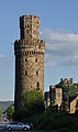
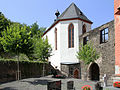
- Schönburg
- City wall : The city wall built at the beginning of the 13th century was expanded and reinforced in the 14th century. With its 16 defense towers (originally 22) - u. a. Hospitalgassenturm, Steingassenturm, Katzenturm and Ochsenturm, the most striking tower with a crenellated wreath and attached octagon ( butter barrel tower ) - the best preserved walling on the Middle Rhine . Most of the wall is now accessible, especially in the northern sections. Access to some sections that are not yet accessible are planned.
- Market square with town hall from 1842 and half-timbered houses (wine bars and restaurants)
Sacred buildings from the 14th to the 19th century

Liebfrauenkirche, first half of the 14th century

St. Martin, first half of the 14th century
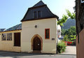
Katharinenkapelle, 2nd half of the 14th century
Michael's chapel with ossuary, mid-14th century
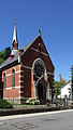
Evangelical Church, late 19th century


_Oberwesel,_Unterstra%C3%9Fe_12-14.jpg)


- To Our Lady of Sorrows (Engehöll)
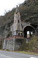
- Mother Rosa Chapel : Choir of the former chapel of the hospital destroyed in 1689 (former Werner chapel).

- Liebfrauenkirche : Construction began in 1308. It was consecrated in 1331 and completed in 1375. It was built in place of a previous church, which was first mentioned in 1213. From this St. Mary's Church, today's church took over a pen for secular priests (as opposed to religious priests). In terms of its architecture and furnishings (gold altar, rood screen , wall paintings) it is one of the most important Gothic churches in the Rhineland.
- St. Martin : Gothic building from 1350 on the basis of a previous Romanesque building; the building was not completed due to the poor economic situation of the monastery. The tower built into the city wall for defense purposes during the Wesel War is an illustrative example of sacred defense architecture in the Rhineland. Much of the Gothic interior has been destroyed. Some wall paintings from around 1500/1600 have been preserved.
- Minorite monastery : The Franciscan monastery founded in 1242 was abolished by Napoleon in 1802. It was destroyed in the great city fire of 1836 and has been in ruins ever since.
- Evangelical Church : Built from 1897 to 1899 according to plans by the architect August Heins (1848–1913) from Boppard on Chablisstraße as a neo-Gothic, brick-faced hall church.
- Former synagogue : The synagogue, which existed on Schaarplatz from 1886 to 1938, was subsequently converted into a residential building.
Award for active monument protection
In 2008, the German National Committee for Monument Protection awarded the Oberwesel construction association "Historische Stadt Oberwesel eV" the silver hemisphere in recognition of its services to monument protection . The annual award honors the commitment to the preservation and rescue of buildings, ensembles, old town cores, villages and archaeological monuments.
See also: List of cultural monuments in Oberwesel
Regular events
- Annual concert "We make music" by the wind orchestra of the Kolping Family Oberwesel
- Wine Witches Night
- Medieval Spectaculum - at Pentecost in even years.
- Middle Rhine Marathon from Oberwesel to Koblenz in June (2005 to 2015 for the last time)
- Rhine in Flames - Night of 1000 Fires - with a traditional pageant on the Sunday after, the second Saturday in September
- Wine market on the market square and in Rathausstrasse, every 2nd and 3rd weekend in September
Economy and Infrastructure
traffic
Oberwesel has a train station on the left Rhine route . The Oberwesel station, which opened on December 15, 1859, is staffed by a dispatcher from DB Netz .
The federal road 9 connects with the neighboring towns and the regional centers Koblenz and Mainz . The state road 220 leads to the Rhine heights and into the Hunsrück . The right bank of the Rhine can be reached with the car ferry Bacharach - Kaub or the Loreley ferry , both of which are only a few kilometers away from the city.
Viticulture
.jpg)
Within the growing region Middle Rhine Oberwesel one of the largest wine-growing communities. The large site at Schönburg Castle covers 72 hectares; Individual layers are: Sieben Jungfrauen, Oelsberg, Bienenberg, St. Martinsberg, Goldemund, Bernstein, Römerkrug. The vineyards are steeply terraced and about 80% planted with Riesling and 20% with other white grape varieties ( Müller-Thurgau , Kerner , Pinot Blanc ) and, more rarely, red grape varieties ( Pinot Noir , Dornfelder ). Wines of all types of aging (mild, semi-dry and dry) as well as quality levels ( predicate Kabinett to occasionally ice wine ) are achieved. A gentle land consolidation was recently carried out in the Oelsberg and the newly planted vineyards were provided with an irrigation system. Thus this traditional situation could be secured. In addition to saving work for the winemaker, this also means securing yields in dry summers.
Some of the 30 or so local wineries have been family-owned for over 200 years, and some have a bar in town. The Lanius-Knab winery is the only member of the Association of German Predicate and Quality Wineries (VDP).
tourism
The youth hostel on the Schönburg is the largest in Rhineland-Palatinate with 269 beds and recorded over 57,000 overnight stays in 2017.
Personalities
sons and daughters of the town
- Johann von Wesel (1425–1481), theologian
- Joseph Adamy (1778–1849), Nassau mine owner and politician
- August Zeuner (1913–1976), German politician
- Johann Peter Josten (1915–2011), German politician
- Wilhelm Lauer (1923–2007), geographer and professor
- Alfred Gottschalk (1930–2009), rabbi
- Robert Brahm (* 1956), auxiliary bishop
- Wolfgang Brenner (* 1956), painter
- Eberhard Lauer (* 1956), church musician
literature
- Eduard Sebald and co-authors: The art monuments of Rhineland-Palatinate, volume 9. The art monuments of the Rhein-Hunsrück district, part 2. Former district of St. Goar, here the city of Oberwesel in volumes I and II, State Office for Monument Preservation Rhineland-Palatinate ( Ed.) Deutscher Kunstverlag 1977 ISBN 3-422-00576-5
- Ferdinand Pauly in: Germania Sacra , The Dioceses of the Church Province of Trier. The Archdiocese of Trier 2. The monasteries St. Severus in Boppard, St. Goar in St. Goar, Liebfrauen in Oberwesel, St. Martin in Oberwesel . Walter de Gruyter, Berlin - New York 1980
- Anton Ph. Schwarz and Winfried Monschauer: Citizens under the protection of their walls. 800 years of Oberwesel city fortifications . Edited by Bauverein Historische Stadt Oberwesel, 2012
- Gregor Monachauer in: The Cistercian convent of All Saints in Oberwesel , contributions to the history of the city of Oberwesel (I). Ed .: Josef Heinzelmann, Winfried Monschauer, Eberhard J. Nikitsch. Pennrich Druck Bingen am Rhein, 2010
- Jochen von Osterroth, in: History of the Schönburg , Hüttl u. Osterroth (ed.). Publishing house, CI-IT Consulting & Design, Wiebelsheim
- Winfried Monschauer: The Minorite Monastery in Oberwesel - history of an extraordinary monument. (Ed.) Kulturstiftung Hütte Oberwesel, 2013. ISBN 978-3-00-043393-1
- The art monuments of Rhineland-Palatinate, Vol. 9, The art monuments of the Rhein-Hunsrück district, part 2. Former district of St. Goar, 2. City of Oberwesel , edit. v. Eduard Sebald, Hans Caspary, Ludger Fischer a . a .; Munich, / Berlin: Deutscher Kunstverlag, 1997
- Ludger Fischer , Josef Heinzelmann, Wilhelm Hermann, Edmund Lahnert, Dieter Metzger: Heimat Oberwesel. Between Liebfrauen and St. Martin. A city guide. Oberwesel 1992
- Hans-Jürgen Kotzur : High Gothic dialogue. A comparison of the sculptures on the high altars in Marienstatt and Oberwesel. Worms 1993
- Josef Heinzelmann : On the historical urban development of Oberwesel. In: Adventure archeology. Issue No. 7, 2005, pp. 36-48. ISSN 1615-7125
- Joachim Busch, Oberwesel and the Railway: 150 Years of Railway History on the Middle Rhine - Simmern 2009 - ISBN 978-3-9809840-2-7
Documents
- Picture of Schönburg Castle from JF Dielmann, A. Fay, J. Becker (draftsman): FC Vogel's Panorama of the Rhine, pictures of the right and left banks of the Rhine, FC Vogel lithographic institution, Frankfurt 1833
- Image from Oberwesel
- Picture 2 from Oberwesel
- Fig. 3 Oberwesel area
- Fig. 4 Oberwesel area
Web links
- Homepage of the city of Oberwesel
- Verbandsgemeinde Oberwesel
- Illustration of the city in 1588 in Civitates orbis terrarum by Georg Braun and Frans Hogenberg
- Historical information about Engehöll at regionalgeschichte.net
- Illustration by Daniel Meisner from 1626: Oberwesel. Virgines vagabundas devita ( digitized version )
- Literature about Oberwesel in the Rhineland-Palatinate state bibliography
Individual evidence
- ↑ State Statistical Office of Rhineland-Palatinate - population status 2019, districts, communities, association communities ( help on this ).
- ↑ a b State Statistical Office Rhineland-Palatinate - regional data
- ↑ Kilometrage at steppenhahn.de (accessed January 2015)
- ^ Oelsberg at the Kauer winery
- ↑ Flood Guide Oberwesel ( Memento of the original from January 12, 2015 in the Internet Archive ) Info: The archive link was inserted automatically and has not yet been checked. Please check the original and archive link according to the instructions and then remove this notice. (Accessed January 2015)
- ↑ a b c d e f g h Anton Ph. Schwarz in: Citizens in the protection of their walls. 800 years of Oberwesel city fortifications , pp. 7–29
- ↑ a b On the history of Oberwesel: early history, in: regionalgeschichte.net. Retrieved January 8, 2015 .
- ↑ Eduard Sebald, Die Kunstdenkmäler des Rhein-Hunsrück-Kreis Part 2. Former district of St. Goar, here City of Oberwesel Volume 2, p. 1043 ff
- ↑ Eduard Sebald: The art monuments of the Rhein-Hunsrück district part 2. Former district of St. Goar, here City of Oberwesel Volume 2, p. 720.
- ↑ Gregor Monschauer in: The Cistercian Monastery of All Saints in Oberwesel , pp. 7 to 71
- ↑ Jochen von Osterroth, in: History of the Schönburg, p. 9.
- ^ Ferdinand Pauly in: Germania Sacra, The Dioceses of the Church Province Trier. Here: The Liebfrauen and St. Martin monasteries in Oberwesel , pp. 267 to 511
- ↑ Gregory Monachauer referring to Štramberk: "Metropolis Ecclesiae Trevericae". Tomus II. Koblenz 1856 p. 183, in: The Cistercian Convent of All Saints in Oberwesel
- ↑ Monachauer, in: The Cistercian Convent of All Saints in Oberwesel
- ↑ Winfried Monschauer: The Minorite Monastery in Oberwesel , p. 7 ff
- ↑ Eduard Sebald: The art monuments of the Rhein-Hunsrück district part 2. Former district of St. Goar, here City of Oberwesel Volume 2, Oberwesel city center, Die Stadtbefestigung, p. 813 ff
- ↑ Konrad Schilling In: Monumenta Judaica. 2000 years of history and culture of the Jews on the Rhine . Here "Taxes" p. 209 ff
- ↑ Eduard Sebald: The art monuments of the Rhein-Hunsrück district part 2. Former district of St. Goar, here City of Oberwesel Volume 1, section Former Hl. Geist-Hospital p. 694 ff
- ↑ Isabelle Haßler: "Wesalia Superior" - functional elite of the city of Oberwesel in the Middle Ages . Master's thesis Saarbrücken, Grin Verlag for academic texts, Munich, 2007, ISBN 978-3-638-91982-1 .
- ↑ Sebald: The art monuments of the Rhein-Hunsrück district , part 2: Former district of St. Goar, here city of Oberwesel , volume 2. P. 803 u. Pp. 931-932.
- ↑ Eduard Sebald: The art monuments of the Rhein-Hunsrück district part 2. Former district of St. Goar, here City of Oberwesel Volume 2, Oberwesel city center, Dir city fortifications, p. 813 ff
- ↑ Eduard Sebald: The art monuments of the Rhein-Hunsrück district part 2. Former district of St. Goar, here City of Oberwesel Volume 2, section residential buildings, p. 914 ff
- ^ Konrad Schilling in: Monumenta Judaica. 2000 years of history and culture of the Jews on the Rhine . Here “State Archives Koblenz, I documents, inventory 1 A No. 4417 (Jan. 24, 1309)” note 67, p. 237
- ↑ Eduard Sebald: The art monuments of the Rhein-Hunsrück district part 2. Former district of St. Goar, here City of Oberwesel Volume 1, p. 84
- ↑ Eduard Sebald: The art monuments of the Rhein-Hunsrück-Kreis part 2. Former district of St. Goar, here City of Oberwesel Volume 2, public buildings p. 896 f, Unterstraße p. 1000 ff and Volume 1, former Heilig-Geist-Hospital / Werner Chapel p. 671 ff
- ^ Ferdinand Pauly: History of the Catholic Church . In: State Office for Monument Preservation (Hrsg.): The art monuments of Rhineland-Palatinate . tape 8 . The art monuments of the Rhein-Hunsrück district. Part 2. Former district of St. Goar, 1. City of Boppard I. Deutscher Kunstverlag, Munich / Berlin 1988, ISBN 3-422-00567-6 , p. 468-469 .
- ^ Franz-Josef Heyen, Political History in:> Eduard Sebald: Die Kunstdenkmäler des Rhein-Hunsrück-Kreis Part 2. Former district of St. Goar, here City of Oberwesel Volume 1, Section Introduction, p. 1 f
- ↑ Eduard Sebald: The art monuments of the Rhine-Hunsrück district part 2. Former district of St. Goar, here City of Oberwesel Volume 2, section Technical monuments p. 1020 f
- ↑ Eduard Sebald and co-authors: The art monuments of Rhineland-Palatinate, Volume 9. The art monuments of the Rhein-Hunsrück district, part 2. Former district of St. Goar, 2 volumes on the city of Oberwesel, here in volume II, technical monuments p. 1021/23
- ^ Anton Ph. Schwarz and Winfried Monschauer: Citizens in the protection of their walls. 800 years of Oberwesel city fortifications , p. 123.
- ↑ Joachim Busch in: Oberwesel and the Railway, Section 3, p. 14 ff.
- ↑ Eduard Sebald and co-authors: The art monuments of Rhineland-Palatinate, Volume 9. The art monuments of the Rhein-Hunsrück district, part 2. Former district of St. Goar, 2 volumes on the city of Oberwesel, here in volume II, public buildings p. 903 ff
- ↑ Eduard Sebald and co-authors: The art monuments of Rhineland-Palatinate, Volume 9. The art monuments of the Rhein-Hunsrück district, part 2. Former district of St. Goar, 2 volumes on the city of Oberwesel, here in volume 1: Political history p. 1
- ↑ a b Official municipality directory 2006 ( Memento from December 22, 2017 in the Internet Archive ) (= State Statistical Office Rhineland-Palatinate [Hrsg.]: Statistical volumes . Volume 393 ). Bad Ems March 2006, p. 191, 198 (PDF; 2.6 MB). Info: An up-to-date directory ( 2016 ) is available, but in the section "Territorial changes - Territorial administrative reform" it does not give any population figures.
- ↑ Announcement of the results of the election to the Oberwesel City Council. (PDF) June 3, 2019, accessed on August 10, 2019 .
- ^ The Regional Returning Officer Rhineland-Palatinate: Municipal elections 2014, city and municipal council elections
- ↑ The regional returning officer RLP: direct elections 2019. see Hunsrück-Mittelrhein, Verbandsgemeinde, 24th line of results. Retrieved October 1, 2019 .
- ^ City history on the partnership with Chablis
- ↑ The Church of Our Lady of Oberwesel, Anton Ph. Schwarz, 2001
- ↑ Schwarz and Monschauer: Citizens under the protection of their walls. 800 years of Oberwesel city fortifications, p. 144 f
- ↑ Wolfgang Wendling: Oberwesel youth hostel most popular . in: Rhein-Zeitung , January 15, 2018, accessed on January 17, 2018.

Alterkülz | Altweidelbach | Argenthal | Badenhard | Bärenbach | Belg | Belgweiler | Bell (Hunsrück) | Beltheim | Benzweiler | Bergenhausen | Bulging | Bickenbach | Beavers | Birkheim | Boppard | Braunshorn | Bubach | Book | Büchenbeuren | Budenbach | Damscheid | Dichtelbach | Dickenschied | Dill | Dillendorf | Dommershausen | Dörth | Ellern (Hunsrück) | Emmelshausen | Erbach | Fronhofen | Gehlweiler | Gemünden | Gödenroth | Gondershausen | Rooster | Halsenbach | Hasselbach | House Bay | Hedges | Heinzenbach | Henau | Hirschfeld | Hollnich | Holzbach | Horn | Hungenroth | Kappel | Karbach | Kastellaun | Keidelheim | Kirchberg (Hunsrück) | Kisselbach | Klosterkumbd | Kludenbach | Korweiler | Kratzenburg | Külz (Hunsrück) | Kümbdchen | Lahr | Laubach | Laudert | Laufersweiler | Lautzenhausen | Leiningen | Liebshausen | Lindenschied | Linger Hahn | Maisborn | Maitzborn | Mastershausen | Mengiffer | Mermuth | Metzenhausen | Michelbach | Mörschbach | Mörsdorf | Morshausen | Mill path | Mother difference | Nannhausen | Neuerkirch | Ney | Low cost | Niederburg | Niederkumbd | Low ears | Niedert | Niederweiler | Norath | Upper cost | Oberwesel | Ohlweiler | Oppertshausen | Perscheid | Pfalzfeld | Pleizenhausen | Ravengiersburg | Raversbeuren | Rayanders | Reckershausen | Empire | Rheinböllen | Riegenroth | Riesweiler | Rödelhausen | Rödern | Rohrbach | Roth | Sankt Goar | Sargenroth | Conclusion | Schnorbach | Schönborn | Torrent | Blacks | Simmern / Hunsrück | Sohren | Sohrschied | Expense red | Steinbach | Thörlingen | Tiefenbach | Death Red | Uhler | Unzenberg | Urbar | Utzenhain | Wahlbach | Wahlenau | Wiebelsheim | Womrath | Woppenroth | Würrich | Wüschheim | Zilshausen