
Maitzborn
| coat of arms | Germany map | |
|---|---|---|

|
Coordinates: 49 ° 56 ' N , 7 ° 26' E |
|
| Basic data | ||
| State : | Rhineland-Palatinate | |
| County : | Rhein-Hunsrück district | |
| Association municipality : | Kirchberg (Hunsrück) | |
| Height : | 387 m above sea level NHN | |
| Area : | 3.15 km 2 | |
| Residents: | 107 (Dec. 31, 2019) | |
| Population density : | 34 inhabitants per km 2 | |
| Postal code : | 55481 | |
| Area code : | 06763 | |
| License plate : | SIM, GOA | |
| Community key : | 07 1 40 090 | |
| Association administration address: | Marktplatz 5 55481 Kirchberg (Hunsrück) |
|
| Website : | ||
| Mayoress : | Renate Förster-Hoemberg | |
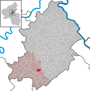
| Location of the local community Maitzborn in the Rhein-Hunsrück district | ||
  |
||


Maitzborn is a municipality in the Rhein-Hunsrück district in Rhineland-Palatinate . It belongs to the Kirchberg (Hunsrück) community .
geography
Maitzborn is centrally located in the Hunsrück , near the town of Kirchberg . To the east of the village is the Kauerbachtal , to the west of the village is the federal road 421 .
history
Maitzborn was probably settled in Franconian times. The first documentary mention is in the Sponheim slope register and dates from the year 1304. With the occupation of the left bank of the Rhine by French revolutionary troops in 1794 , the place became French, in 1815 it was assigned to the Kingdom of Prussia at the Congress of Vienna . Since 1946 the place has been part of the newly founded state of Rhineland-Palatinate.
More than 40 burial mounds were found in Maitzborn, whose name could refer to a source of sacrifice. You are in the eastern area of the town marker.
politics
Municipal council
The council in Maitzborn consists of six council members, who in the local elections on May 26, 2019 in a majority vote were elected, and the honorary mayor as chairman.
mayor
Renate Förster-Hoemberg is the local mayor of Maitzborn. In the local elections on May 26, 2019, there was no candidate, she was elected by the local council and is the successor to Karl-Heinz Dreher.
coat of arms
|
|
Blazon : "Under the head of the shield in gold, sheathed in two rows of blue and gold, diagonally right, a red bar, accompanied by a red sheaf at the top and a red fountain at the bottom." |
|
Justification of the coat of arms: The chess in blue and gold in the shield head reminds of the fact that the place belongs to the front county of Sponheim . From the 15th century to 1708 there was a joint administration of the Electoral Palatinate , the ducal Palatinate-Simmerian and margravial Baden administration. Red and gold in the coat of arms refer to the coat of arms of the margraves of Baden. The affiliation to Baden existed from 1708 to 1794.
The fountain stands for the courtyard fountains that once existed in the community and helped shape the place name. The grain sheaf is a symbol of the community's important agricultural profession. |
Web links
- Article about Maitzborn in the television program Hierzuland
- Maitzborn on the website of the Kirchberg Association
- Literature about Maitzborn in the Rhineland-Palatinate state bibliography
Individual evidence
- ↑ State Statistical Office of Rhineland-Palatinate - population status 2019, districts, communities, association communities ( help on this ).
- ^ The Regional Returning Officer RLP: City Council Election 2019 Maitzborn. Retrieved October 7, 2019 .
- ^ The Regional Returning Officer RLP: direct elections 2019. see Kirchberg, Verbandsgemeinde, 20th line of results. Retrieved October 7, 2019 .
- ↑ Verbandsgemeinde Kirchberg: local community Maitzborn. Local council. Retrieved October 7, 2019 .
- ↑ Maitzborn coat of arms description

Alterkülz | Altweidelbach | Argenthal | Badenhard | Bärenbach | Belg | Belgweiler | Bell (Hunsrück) | Beltheim | Benzweiler | Bergenhausen | Bulging | Bickenbach | Beavers | Birkheim | Boppard | Braunshorn | Bubach | Book | Büchenbeuren | Budenbach | Damscheid | Dichtelbach | Dickenschied | Dill | Dillendorf | Dommershausen | Dörth | Ellern (Hunsrück) | Emmelshausen | Erbach | Fronhofen | Gehlweiler | Gemünden | Gödenroth | Gondershausen | Rooster | Halsenbach | Hasselbach | House Bay | Hedges | Heinzenbach | Henau | Hirschfeld | Hollnich | Holzbach | Horn | Hungenroth | Kappel | Karbach | Kastellaun | Keidelheim | Kirchberg (Hunsrück) | Kisselbach | Klosterkumbd | Kludenbach | Korweiler | Kratzenburg | Külz (Hunsrück) | Kümbdchen | Lahr | Laubach | Laudert | Laufersweiler | Lautzenhausen | Leiningen | Liebshausen | Lindenschied | Linger Hahn | Maisborn | Maitzborn | Mastershausen | Mengiffer | Mermuth | Metzenhausen | Michelbach | Mörschbach | Mörsdorf | Morshausen | Mill path | Mother difference | Nannhausen | Neuerkirch | Ney | Low cost | Niederburg | Niederkumbd | Low ears | Niedert | Niederweiler | Norath | Upper cost | Oberwesel | Ohlweiler | Oppertshausen | Perscheid | Pfalzfeld | Pleizenhausen | Ravengiersburg | Raversbeuren | Rayanders | Reckershausen | Empire | Rheinböllen | Riegenroth | Riesweiler | Rödelhausen | Rödern | Rohrbach | Roth | Sankt Goar | Sargenroth | Conclusion | Schnorbach | Schönborn | Torrent | Blacks | Simmern / Hunsrück | Sohren | Sohrschied | Expense red | Steinbach | Thörlingen | Tiefenbach | Death Red | Uhler | Unzenberg | Urbar | Utzenhain | Wahlbach | Wahlenau | Wiebelsheim | Womrath | Woppenroth | Würrich | Wüschheim | Zilshausen