Kandrich
| Kandrich | ||
|---|---|---|
|
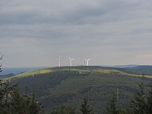
View from the Hochsteinchen observation tower to Kandrich |
||
| height | 638.6 m above sea level NHN | |
| location | near Daxweiler ; District of Bad Kreuznach , Rhineland-Palatinate ( Germany ) | |
| Mountains | Binger Forest ( Hunsrück ) | |
| Dominance | 3.5 km → Hochsteinchen | |
| Notch height | 192 m ↓ farm road about 2.6 km northeast of Dichtelbach | |
| Coordinates | 49 ° 59 '38 " N , 7 ° 43' 42" E | |
|
|
||
| Development | Forest paths | |

The Kandrich near Daxweiler in the Rhineland-Palatinate district of Bad Kreuznach is 638.6 m above sea level. NHN the highest point in the Binger Forest .
geography
location
The Kandrich lies in the northern tip of the Bad Kreuznach district and belongs to the municipal area of Daxweiler . It is located about 3.5 km north-north-west of this municipality and 3.7 km north-north-east of Seibersbach . In the neighboring Rhein-Hunsrück district , Dichtelbach is 3 km away in the northwest and Rheinböllen is 4.2 km away in the west-northwest (depending on the beeline ). The Nahe tributary Guldenbach runs southwest past the mountain . The northeast branch of the Kandrich is the Ohligsberg ( 604.1 m ) and its southwest branch is the Hammerberg ( 583.6 m ).
On the mountain are part of the protected landscape Rhine area from Bingen to Koblenz ( CDDA -No 323852;. Reported in 1978; 403.28 km² ).
Natural allocation
The Kandrich belongs in the natural spatial main unit group Hunsrück (No. 24) and in the main unit Soonwald (240) to the sub-unit Binger Wald (240.0).
Military use
The military use of the Kandrich began on May 20, 1963, when the American military took over the use of a fire control area (radar system) of a nuclear-equipped Nike anti-aircraft unit stationed nearby . This weapon system was replaced in 1982 and the former radar system was subsequently converted into a location for the new MIM-104 Patriot anti-aircraft missile system.
From 1986 to 1991, a division of the 6th Air Defense Artillery Battalion of the United States Armed Forces was stationed on the mountain with Patriot missiles that were withdrawn as part of the Second Gulf War . Eight Hardened Aircraft Shelters were built on the summit to store the missiles .
The contract for a military use of the Kandrich expired on September 30, 1992. The dismantling, decontamination and recultivation of the former military site was not completed until 2006.
Wind farm and transmission mast
On the unwooded summit plateau and the Ohligsberg there is a large wind farm that has grown steadily in recent years. The first plant of the type Enercon E-66 / 15.66 with a nominal output of 1.5 megawatts (MW) was officially put into operation on August 17, 1999, the second plant of the type Enercon E-66 / 18.70 on October 19, 2000 an increased nominal output of 1.8 MW compared to the older system. In October 2005 the third Enercon E-70 system went into operation. All three systems were built by Gedea-EnergieMix GmbH & Co Windkraftanlagen Ingelheimer Wald / Kandrich KG .
In August 2012, the expansion of the wind farm began with two Enercon E-101s . These plants have a nominal output of 3.05 MW and with a total height of 185 clearly surpass the three older plants. In spring 2013 these systems, which were also built and operated by Kandrich KG , were completed. Turbines of the type Enercon E-126 were originally planned , the world's most powerful series turbine, which is used in the neighboring Ellern wind farm , but an economical operation with turbines of this size at Kandrich turned out to be unprofitable.
At the beginning of 2013, the construction of another two Enercon E-101 started , which, however, in contrast to the already completed ones, have a larger hub height of 149 m. They were among the first systems of the type to be built with this hub height.
However, the largest expansion took place in 2014. In the Kandrich wind park, which is designated as a community wind park, juwi , Thüga renewable energies and WEMAG built a total of nine further Enercon E-101 turbines . This extension officially went into operation on July 31, 2014.
There are now 16 wind turbines with a total output of 44.6 MW on the Kandrich.
There is also a transmission mast around 60 m southwest of the mountain peak ( ⊙ ).
Johann Georg Sabellicus Faustus
According to a theory outlined in literature by Gustav Pfarrius (1800–1884) in the novella Schein or Sein in 1862 , Johann Georg Sabellicus Faustus (around 1480 – around 1541), who was probably born on the Fustenburg near Stromberg , wrote the historical archetype of Dr. Faust - his soul to the devilish Mephistopheles in the mountain solitude of Kandrich.
Traffic and walking
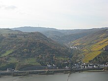
In the lower area of the southwest flank of the Kandrich, the federal motorway 61 runs along above the Guldenbach . On the other side of it runs the state road 214 (Rheinböllen - Stromberg ), from which the district road 35 ( Rheinböllerhütte --Dichtelbach), which runs over the western flank, branches off. From Dichtelbach you can walk on forest paths to the summit plateau.
Coming from Waldalgesheim , the K 29 leads mainly north-west to the Lauschhütte forester's lodge near the Salzkopf , where it bends south at a height of 583.4 m and shortly afterwards changes to the K 36, which runs south-south-west to Daxweiler. From the Lauschhütte you have to cover an approximately 3.5 km long forest path to the west to the summit. Signposted paths lead from the forester's house to the Salzkopf, among other places.
The European long-distance hiking trail E8 leads north-east past the Kandrich and the Ohligsberg .
Individual evidence
- ↑ a b c d Map service of the landscape information system of the Rhineland-Palatinate nature conservation administration (LANIS map) ( notes )
- ↑ Map services of the Federal Agency for Nature Conservation ( information )
- ↑ Missile positions in Germany , on globezoom.info
- ↑ Delta 2nd BN 1st ADA 32nd AADCOM Dichtelbach, Germany , on d21dichtelbach.com
- ↑ NATO Station (Patriot rockets) , on bbs.keyhole.com
- ↑ More wind turbines are worthwhile - but the community is against the construction ... on huegelland.net
- ↑ Wind turbines Kandrich I + II in the Hunsrück , on gedea.de
- ↑ News from the Kandrich wind power plant , on kandrich.de
- ↑ Kandrich IV + V approved , on gedea.de
Web links
- Wind power plant Kandrich (kandrich.de)
- Kandrich hiking trails (stromberg.de; PDF file; 3.98 MB)


