
Oberdiebach
| coat of arms | Germany map | |
|---|---|---|

|
Coordinates: 50 ° 2 ' N , 7 ° 47' E |
|
| Basic data | ||
| State : | Rhineland-Palatinate | |
| County : | Mainz-Bingen | |
| Association municipality : | Rhine-Nahe | |
| Height : | 90 m above sea level NHN | |
| Area : | 8.37 km 2 | |
| Residents: | 824 (Dec. 31, 2019) | |
| Population density : | 98 inhabitants per km 2 | |
| Postal code : | 55413 | |
| Area code : | 06743 | |
| License plate : | MZ , BIN | |
| Community key : | 07 3 39 044 | |
| Community structure: | 3 districts | |
| Association administration address: | Koblenzer Strasse 18 55411 Bingen am Rhein |
|
| Website : | ||
| Local Mayor : | Bernhard Laudert | |
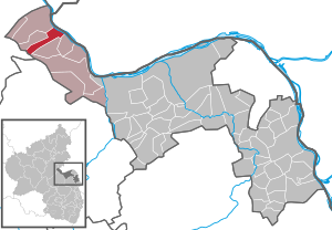
| Location of the local community Oberdiebach in the Mainz-Bingen district | ||
  |
||

.jpg)
Oberdiebach is a municipality in the Mainz-Bingen district in Rhineland-Palatinate . It belongs to the Rhein-Nahe Association , which has its administrative headquarters in the city of Bingen am Rhein . Since 2002 Oberdiebach has been part of the UNESCO World Heritage Upper Middle Rhine Valley .
geography
Oberdiebach is located in the Middle Rhine Valley between Koblenz and Mainz . The closest larger city is Bingen am Rhein, about 10 kilometers (as the crow flies) southwest .
The districts of the community are Oberdiebach, Rheindiebach and Winzberg.
history
- 893: Oberdiebach is mentioned for the first time
- 1220: The Fürstenberg Castle (Rheindiebach) is from Cologne electors on the border with Kurmainz built
- 1461: first mention of Rheindiebach (Dyepach Ryne)
- 1689: The French destroy Fürstenberg Castle in the Palatinate War of Succession .
- 1822: The MGV "Eintracht" is founded and is still one of the oldest choral societies in Rhineland-Palatinate
The development of the population of Oberdiebach, the values from 1871 to 1987 are based on censuses:
|
|
politics

Municipal council
The local council in Oberdiebach consists of twelve council members, who were elected in a personalized proportional representation in the local elections on May 26, 2019 , and the honorary local mayor as chairman.
The distribution of seats in the municipal council:
| choice | CDU | Flat share 1 | Flat share 2 | total |
|---|---|---|---|---|
| 2019 | - | 9 | 3 | 12 seats |
| 2014 | - | 9 | 3 | 12 seats |
| 2009 | - | 8th | 4th | 12 seats |
| 2004 | 3 | 7th | 2 | 12 seats |
- Flat share 1 = Laudert voters group
- WG 2 = voter group Dr. Stelter
mayor
In the 2019 local elections, Bernhard Laudert was directly re- elected as local mayor with 90.4 percent of the vote .
Buildings


- in the district of Oberdiebach the parish church of St. Mauritius (1414) with an altarpiece and iron pulpit.
- in the district of Rheindiebach the castle ruins Fürstenberg and
- half of the tower, formerly part of the Gothic fortifications. Large parts of the fortifications and parts of the tower fell victim to the expansion of Bundesstraße 9 in the second half of the 20th century.
- The Lorch transmitter (Rheingau) is located southeast of Oberdiebach .
Oberdiebach's sons
- Johann Henrich Reitz (1665–1720), well-known radical pietist and author ( impartial church and heretic history )
- Johann Wilhelm Theobald (1726–1816), Father Lazarist , first Provincial of his order in the Electoral Palatinate and pastor of Neustadt an der Weinstrasse
- Klaus Wagner (1937–2005), Hispanist in Seville
economy
Oberdiebach is economically shaped by viticulture. Tourism plays a small but expandable role. Old traditions have been revived not only to promote tourism, but also to promote their own identity as a place. This is how the new guild of Weinschröter came into being , which in the old days was responsible for the transport of heavy and valuable wine barrels and which today maintains old traditions.
traffic
- The next train station is in Niederheimbach on the Mainz – Koblenz railway line .
- Bundesstrasse 9 , which connects Mainz with Koblenz, runs directly through the Rheindiebach part of the municipality .
- The Rheingoldstrasse (here K 27) runs through the side valley, with which one reaches the federal motorway 61 via the neighboring town of Manubach after about 11 km at the junction Rheinböllen . The Rheingoldstrasse itself leads from Rheindiebach over the heights on the left bank of the Rhine to Boppard . It is particularly popular with motorcycle tourists.
- The Rhine Cycle Path runs along the Rhine .
- The Rheinburgenweg long-distance hiking trail touches the town on the Trechtingshausen - Bacharach stage
literature
- Literature about Oberdiebach in the Rhineland-Palatinate state bibliography
- Literature by and about Oberdiebach in the catalog of the German National Library
- Peter Bahn: The history of the Diebachtal. Oberdiebach 1989.
Web links
- Local community Oberdiebach
- On the history of Oberdiebach . Website "regionalgeschichte.net" of the Institute for Historical Regional Studies at the University of Mainz e. V.
- Picture from Rheindiebach from: JF Dielmann, A. Fay, J. Becker (draftsman): F. C. Vogel's Panorama of the Rhine: Views of the right and left banks of the Rhine from Mainz to Coblenz . F. C. Vogel lithographic institute, Frankfurt 1833
Individual evidence
- ↑ State Statistical Office of Rhineland-Palatinate - population status 2019, districts, communities, association communities ( help on this ).
- ↑ State Statistical Office Rhineland-Palatinate - regional data
- ^ The Regional Returning Officer Rhineland-Palatinate: Local elections 2019, city and municipal council elections Retrieved on July 29, 2019
- ↑ The Regional Returning Officer of Rhineland-Palatinate: Local elections 2019, direct elections for the local and city mayors. Accessed on July 29, 2019

Appenheim | Aspisheim | Bacharach | Badenheim | Bingen am Rhein | Bodenheim | Breitscheid (Hunsrück) | Bubenheim (Rheinhessen) | Budenheim | Dalheim (Rheinhessen) | Dexheim | Dienheim | Dolgesheim | Dorn-Dürkheim | Eimsheim | Engelstadt | Essenheim | Friesenheim (Rheinhessen) | Gau-Algesheim | Gau-Bischofsheim | Gensingen | Grolsheim | Guntersblum | Hahnheim | Harxheim | Hillesheim (Rheinhessen) | Horrweiler | Ingelheim am Rhein | Youth home in Rheinhessen | Klein-Winternheim | Koengernheim | Loerzweiler | Ludwigshöhe | Manubach | Mommenheim (Rheinhessen) | Münster-Sarmsheim | Neck home | Nieder-Hilbersheim | Nieder-Olm | Niederheimbach | Nierstein | Ober-Hilbersheim | Ober-Olm | Oberdiebach | Oberheimbach | Ockenheim | Oppenheim | Sankt Johann (Rheinhessen) | Schwabenheim an der Selz | Selzen | Sörgenloch | Jumpers | Stadecken-Elsheim | Trechtingshausen | Uelversheim | Undenheim | Waldalgesheim | Hamlet near Bingen | Weinolsheim | Welgesheim | Wintersheim | Wolfsheim | Home of Wrath | Zotzenheim