
Ludwigshöhe
| coat of arms | Germany map | |
|---|---|---|

|
Coordinates: 49 ° 49 ' N , 8 ° 21' E |
|
| Basic data | ||
| State : | Rhineland-Palatinate | |
| County : | Mainz-Bingen | |
| Association municipality : | Rhine-Selz | |
| Height : | 86 m above sea level NHN | |
| Area : | 2.99 km 2 | |
| Residents: | 564 (Dec. 31, 2019) | |
| Population density : | 189 inhabitants per km 2 | |
| Postal code : | 55278 | |
| Area code : | 06249 | |
| License plate : | MZ , BIN | |
| Community key : | 07 3 39 035 | |
| LOCODE : | DE LGX | |
| Association administration address: | Sant 'Ambrogio-Ring 33 55276 Oppenheim |
|
| Website : | ||
| Local Mayor : | Hartmut Zimmermann | |
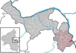
| Location of the local community Ludwigshöhe in the Mainz-Bingen district | ||
  |
||


Ludwigshöhe is a municipality in the Rheinhessen district of Mainz-Bingen in Rhineland-Palatinate . It belongs to the Rhein-Selz community , which has its administrative headquarters in the city of Oppenheim .
Geographical location
Ludwigshöhe is located in the Upper Rhine Plain a little west of the Rhine on the old trade route Mainz - Worms , today's Bundesstraße 9 , almost exactly in the middle between the Rhineland-Palatinate state capital Mainz and the Nibelungen city of Worms.
history
_15.10.2017.jpg)
Ludwigshöhe is a comparatively young place, but goes back to the Merovingian Rudelsheim . A dam break in 1819 caused the residents of Rudelsheim to relocate to a nearby hill.
Rudelsheim was first mentioned on March 21, 766 in a deed of donation from the Lorsch Monastery , in the year of Pippin the Younger's reign . At that time Franco gave a vineyard in Rudolfesheim to save his soul . The place name with the ending -heim indicates a foundation in the time of the Merovingians in the 5th or 6th century by the Franks . The place was named after Rudolf , who on April 2 or 3, 767 gave the Lorsch Monastery a vineyard. The small town is named with 13 documents in the Lorsch Codex .
Having already the Romans the viticulture had brought to the area, this agrarian form was taken over by the Franks. Above all, the monasteries continued to cultivate vines and perfected them.
Rudelsheim was despite partial acquisition of the village in 1418 by Count Palatine Ludwig III. imperial knighthood . Until the end of the 18th century, these sovereign rights lay with the Freiherrn von Dienheim.
The place consisted of 20 houses in 1496 and belonged to the diocese of Worms .
In 1631 the decisive battle between the Protestant troops under the command of the Swedish King Gustav Adolf and the Catholic Spaniards took place south of Rudelsheim . In the course of this, the village burned down completely. The reconstruction of the Church of St. Vitus lasted until its completion in 1736.
After the Thirty Years' War , economic and religious refugees from Switzerland were settled in the Electoral Palatinate by the Palatinate Elector Karl I. Ludwig . Around 1700 three Mennonite families are known in Rudelsheim:
- Jacob Müller with four children
- Hanns / Johannes Meyer ∞ Anna Baumann
- Hans Jacob Hagmann / Hackmann ∞ Maria Brubacher
In 1784 there were 43 houses in Rudelsheim, the Church of St. Vitus and a parish house and barn.
In the Middle Ages, Rudelsheim was located close to or directly on the Rhine , which - at that time not yet straightened - could change its course with every flood and repeatedly caused considerable damage to the village. The flood of the Rhine in 1740 destroyed the spring crops by flooding the fields, and in 1758 the entire harvest was destroyed. But direct damage to buildings was also the result of the recurring floods. In 1784 the Rhine flood flooded the place so that only the roofs protruded from the floods. The floods of 1799 caused seven houses to collapse, and that of 1809 six houses. The number of inhabitants decreased continuously. Many former Rudelsheim residents moved to the higher-up Dienheim. In 1806 there were 380 inhabitants, in 1815 only 319 and in the year of the decisive dam break in 1819 even 278 inhabitants.
The devastating breach of the dam in December 1819 led to the relocation of the village to a hill further to the west. The foundation stone was laid on August 25, 1822, the name day of the then sovereign, Grand Duke Ludwig I of Hesse-Darmstadt , in whose honor the new village was named "Ludwigshöhe". The old Rudelsheim was demolished and relocated until 1830; the church, the only remaining building, fell victim to a fire in 1837.
Jewish family names are mostly derived from many Rheinhessen place names , e.g. B. Oppenheimer, Niersteiner, Dexheimer, von Dienheim, Alsheimer, Mettenheimer and also: Rudelsheimer , who have been known in Amsterdam since the end of the 17th century. The Jewish community had a cemetery in Ludwigshöhe until 1937 , the location of which is unknown today.
From 1972 to 2014 Ludwigshöhe belonged to the Guntersblum community and since July 1, 2014 to the Rhein-Selz community .
politics
Municipal council
The municipal council in Ludwigshöhe consists of twelve council members, who were elected by a majority vote in the local elections on May 26, 2019 , and the honorary local mayor as chairman.
mayor
The local mayor is Hartmut Zimmermann. In the local elections on May 26, 2019, he was confirmed in office with 90.77% of the vote.
coat of arms
|
|
Blazon : "In a silver sign foot a blue, surrounded by red flames boiler labeled ST.VITUS , which points to the patronage of the Catholic church, about a rising eight times divided in red and silver gold, winning in blue colored lion with golden Sword in the right front paw. " |
economy
The VDP Weingut Brüder Dr. Becker produces its wines in Ludwigshöhe.
Born in Ludwigshöhe
- Jacob Becker (1864–1949), doctor and member of the Reichstag
- Johann Becker (1869–1951) German politician ( DVP ), MdR , Reich Economics Minister
See also
- Villa Ludwigshöhe Castle near Edenkoben in the Palatinate
- List of cultural monuments in Ludwigshöhe
- List of natural monuments in Ludwigshöhe
literature
- Karl Josef Minst: Lorsch Codex . Lorsch 1970, documents nos .: 1628, 1672, 1733, 1851-1860 .
- Karl Johann Brilmayer : Rheinhessen in the past and present. Giessen 1905, pp. 268-270.
- Henning Kaufmann: Rheinhessen place names. Munich 1976, pp. 136-137.
- Literature about Ludwigshöhe in the Rhineland-Palatinate state bibliography
Web links
Individual evidence
- ↑ State Statistical Office of Rhineland-Palatinate - population status 2019, districts, communities, association communities ( help on this ).
- ↑ State Statistical Office Rhineland-Palatinate: Regional data.
- ↑ Certificate no. 1856
- ↑ Document No. 1857
- ^ Karl Josef Minst: Lorscher Codex, German, Volume III, Donation documents Wormsgau, documents 1628, 1672, 1733, 1851–1860, Lorsch 1970
- ^ Richard Warren Davis, Karen Miller: The Swiss Mennonites Miller
- ^ Hans Meyer Family Genealogy, Kent Hiestand
- ^ Family Tree Maker Online: Descendants of Hockman
- ↑ http://www.alemannia-judaica.de/mainz_bingen_friedhoefe.htm#Ludwigshöhe%20(VG%20Guntersblum)
- ^ The Regional Returning Officer Rhineland-Palatinate: Local elections 2019, city and municipal council elections. Retrieved July 30, 2019 .
- ^ The regional returning officer RLP: direct elections 2019. see Rhein-Selz, Verbandsgemeinde, eleventh line of results. Retrieved September 29, 2019 .

Appenheim | Aspisheim | Bacharach | Badenheim | Bingen am Rhein | Bodenheim | Breitscheid (Hunsrück) | Bubenheim (Rheinhessen) | Budenheim | Dalheim (Rheinhessen) | Dexheim | Dienheim | Dolgesheim | Dorn-Dürkheim | Eimsheim | Engelstadt | Essenheim | Friesenheim (Rheinhessen) | Gau-Algesheim | Gau-Bischofsheim | Gensingen | Grolsheim | Guntersblum | Hahnheim | Harxheim | Hillesheim (Rheinhessen) | Horrweiler | Ingelheim am Rhein | Youth home in Rheinhessen | Klein-Winternheim | Koengernheim | Loerzweiler | Ludwigshöhe | Manubach | Mommenheim (Rheinhessen) | Münster-Sarmsheim | Neck home | Nieder-Hilbersheim | Nieder-Olm | Niederheimbach | Nierstein | Ober-Hilbersheim | Ober-Olm | Oberdiebach | Oberheimbach | Ockenheim | Oppenheim | Sankt Johann (Rheinhessen) | Schwabenheim an der Selz | Selzen | Sörgenloch | Jumpers | Stadecken-Elsheim | Trechtingshausen | Uelversheim | Undenheim | Waldalgesheim | Hamlet near Bingen | Weinolsheim | Welgesheim | Wintersheim | Wolfsheim | Home of Wrath | Zotzenheim