
Friesenheim (Rheinhessen)
| coat of arms | Germany map | |
|---|---|---|
.png)
|
Coordinates: 49 ° 50 ' N , 8 ° 15' E |
|
| Basic data | ||
| State : | Rhineland-Palatinate | |
| County : | Mainz-Bingen | |
| Association municipality : | Rhine-Selz | |
| Height : | 167 m above sea level NHN | |
| Area : | 3.47 km 2 | |
| Residents: | 716 (Dec. 31, 2019) | |
| Population density : | 206 inhabitants per km 2 | |
| Postal code : | 55278 | |
| Area code : | 06737 | |
| License plate : | MZ , BIN | |
| Community key : | 07 3 39 018 | |
| Association administration address: | Sant 'Ambrogio-Ring 33 55276 Oppenheim |
|
| Website : | ||
| Local Mayor : | Daniel Koelsch | |
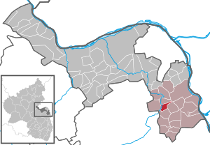
| Location of the local community Friesenheim in the Mainz-Bingen district | ||
  |
||


Friesenheim is a municipality in the Mainz-Bingen district in Rhineland-Palatinate . It belongs to the Rhein-Selz community , which has its administrative headquarters in the city of Oppenheim .
geography
Geographical location
The wine village lies between Mainz and Worms and is a place dominated by agriculture.
Neighboring communities
history
Friesenheim belongs to the group of Rheinhessen towns that arose in the wake of the Franconian conquest. However, there are already traces of settlement from prehistoric times. In 1975 a Neolithic settlement of the Rössen culture with typical ceramics was discovered in the “Spitzäcker” area . In the area of this settlement, some ceramic remains from the Bronze or Iron Ages also appeared. Several finds from the Hallstatt and Latène periods have been known for a long time.
For the first time the name of Friesenheim in the year 803, in Codex Fuldensis mentioned when the Franke Theotbald properties in Dubilesheim and Friesenheim to the monastery of Fulda gave. However, some researchers associate the entry in the Codex with Friesenheim in Alsace . The name is to be interpreted as Friso's home ; a Frisian settlement is out of the question.
The medieval village comprised an area that is bordered by the Neugasse in the south, the Mühlstrasse in the west, the Selz and Dalheimer Bach in the north and the Catholic Church in the east.
Power relations
Around 1190 Werner II von Bolanden of the Wildgraves carried the bailiwick and other sovereign rights over Friesenheim as a fief. The Bolanders passed on the rights granted to them to their vassals. Before Otto von Dienheim enfeoffed the Wigand von Dienheim with village and court in 1322, the knight Heinrich von Selzen and his nephew Peter were the fiefs. In addition to members of the von Dienheim family, other noble families were enfeoffed with sovereign rights in the 14th century. Between 1370 and 1380 Count Heinrich II. Von Sponheim, one of the heirs of the Bolanden family, was feudal lord. From him, the rights were inherited to the Counts of Nassau.
In 1398 Count Philipp von Nassau enfeoffed the Wigand von Dienheim with the village of Friesenheim. The feudal relationship between the Nassau counts and the lords and barons of Dienheim existed for 400 years - until the end of the old empire . As local rulers, the von Dienheim also held high and low jurisdiction . Various other rights were available to the Palatinate , such as B. the wild catch law, which was an imperial fief . That meant when someone to whom no master made a claim moved to Friesenheim, after year and day became serf of the Electoral Palatinate and did not belong to the Lord von Dienheim. So it came about that in the late 17th century all of Friesenheim's residents were serfs in the Electoral Palatinate.
Ownership
Until the Peace of Lunéville in 1801, whose contract provisions provided for the complete expropriation of the noble and spiritual property on the left bank of the Rhine , the vast majority of the place and the district belonged to noble and spiritual owners. Hereditary and temporary tenants built on their estates. The greatest landlords were the barons of Dienheim , who owned three farms with 128, 108 and 40 acres of arable land. They also owned the mill and the bakery. The Freiherren von Frankenstein owned two estates with 109 and 105 acres, which had come to them by inheritance from the von Dienheim family. The barons of Geispitzheim owned an estate of 60 acres for over 500 years as a fief of the St. Alban knight's monastery near Mainz . Another property, which comprised 150 acres, was built by tenants at the Ritterstift. The Odernheim Hospital had 112 acres of field. The parish church built 22 acres. In addition, he received a third of the major and minor tithe. In 1721 the largest farmer owned about 100 acres, two farmers had 40 and 30 acres each. Everything else was small farm holdings, apart from some scattered holdings of the nobility and the church. In the Napoleonic period, the noble and ecclesiastical possessions declared as national goods were auctioned.
politics

Municipal council
The municipal council in Friesenheim consists of twelve council members, who were elected by a majority vote in the local elections on May 26, 2019 , and the honorary local mayor as chairman.
The distribution of seats in the municipal council:
| choice | SPD | FWG | total |
|---|---|---|---|
| 2019 | by majority vote | 12 seats | |
| 2014 | by majority vote | 12 seats | |
| 2009 | 1 | 11 | 12 seats |
| 2004 | 2 | 10 | 12 seats |
- FWG = Free Voting Group Friesenheim
Local mayor
The previous mayor Daniel Kölsch (FWG) was confirmed on May 26, 2019 with a share of the vote of 87.96%.
Transport links
Friesenheim is connected to the B420 federal road via the L425, which takes a few kilometers to reach Nierstein am Rhein in an easterly direction and the A63 in a southerly direction . The distance to Mainz is about 30 kilometers.
It is on the two Rhine-Hessian cycle paths Valtinche and Selztal cycle path .
See also
literature
- Franz Neumer: Friesenheim. History of a village in Rheinhessen. Alzey 2001, ISBN 978-3-87854-156-1 .
- Literature about Friesenheim in the Rhineland-Palatinate State Bibliography
Web links
- Website of the local community Friesenheim
- Historical information about Friesenheim at regionalgeschichte.net
Individual evidence
- ↑ State Statistical Office of Rhineland-Palatinate - population status 2019, districts, communities, association communities ( help on this ).
- ^ The Regional Returning Officer Rhineland-Palatinate: Local elections 2019, city and municipal council elections. Retrieved July 30, 2019 .
- ^ The State Returning Officer Rhineland-Palatinate: Local elections 2019, individual results. Retrieved July 30, 2019 .

Appenheim | Aspisheim | Bacharach | Badenheim | Bingen am Rhein | Bodenheim | Breitscheid (Hunsrück) | Bubenheim (Rheinhessen) | Budenheim | Dalheim (Rheinhessen) | Dexheim | Dienheim | Dolgesheim | Dorn-Dürkheim | Eimsheim | Engelstadt | Essenheim | Friesenheim (Rheinhessen) | Gau-Algesheim | Gau-Bischofsheim | Gensingen | Grolsheim | Guntersblum | Hahnheim | Harxheim | Hillesheim (Rheinhessen) | Horrweiler | Ingelheim am Rhein | Youth home in Rheinhessen | Klein-Winternheim | Koengernheim | Loerzweiler | Ludwigshöhe | Manubach | Mommenheim (Rheinhessen) | Münster-Sarmsheim | Neck home | Nieder-Hilbersheim | Nieder-Olm | Niederheimbach | Nierstein | Ober-Hilbersheim | Ober-Olm | Oberdiebach | Oberheimbach | Ockenheim | Oppenheim | Sankt Johann (Rheinhessen) | Schwabenheim an der Selz | Selzen | Sörgenloch | Jumpers | Stadecken-Elsheim | Trechtingshausen | Uelversheim | Undenheim | Waldalgesheim | Hamlet near Bingen | Weinolsheim | Welgesheim | Wintersheim | Wolfsheim | Home of Wrath | Zotzenheim