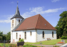
Hillesheim (Rheinhessen)
| coat of arms | Germany map | |
|---|---|---|

|
Coordinates: 49 ° 47 ' N , 8 ° 15' E |
|
| Basic data | ||
| State : | Rhineland-Palatinate | |
| County : | Mainz-Bingen | |
| Association municipality : | Rhine-Selz | |
| Height : | 181 m above sea level NHN | |
| Area : | 5.54 km 2 | |
| Residents: | 662 (Dec. 31, 2019) | |
| Population density : | 119 inhabitants per km 2 | |
| Postal code : | 67586 | |
| Area code : | 06733 | |
| License plate : | MZ , BIN | |
| Community key : | 07 3 39 028 | |
| Association administration address: | Sant 'Ambrogio-Ring 33 55276 Oppenheim |
|
| Website : | ||
| Mayoress : | Melanie Schindel ( SPD ) | |
| Location of the local community Hillesheim in the Mainz-Bingen district | ||
Hillesheim is a municipality in the Mainz-Bingen district in Rhineland-Palatinate . It belongs to the Rhein-Selz community , which has its administrative headquarters in the city of Oppenheim .
geography
Community structure
Hillesheim consists of the center and the district of Bahnhof. The station of the former Osthofen – Gau Odernheim railway line can be found in the Bahnhof district , which was used together with the neighboring village of Dorn-Dürkheim .
Neighboring communities
history
The first documentary mention came about when Erchenbert donated it to the Lorsch monastery on August 18, 772 or 782, when he handed over a field in Hildebotesheim . The church was dedicated to St. Martinus. The foundation stone for the church tower was laid in 1204. The abbess of the monastery Rosenthal near Göllheim had the right of patronage .
In 1387 the properties in the village of Hillesheim were divided. The "Kirchberg part" went to the Rosenthal Abbey on Donnersberg and, as a result of its secularization (1651), was last in the possession of the Counts of Riaucour . The "Haßloch part" remained in imperial hands as the exclave village of the County of Falkenstein and was sold in 1667 to the Duke of Lorraine. As a result, this half of the village fell to Austria in 1736, with the marriage of the Lorraine Duke Franz Stephan and Maria Theresia von Habsburg , and was subordinate to the Oberamt Winnweiler of the imperial part of Upper Austria .
Both parts of the village remained politically separate until the end of the 18th century.
In 1794, Hillesheim was occupied by the French Revolutionary Army, and in 1798 it came to the French Donnersberg department . In 1814, Russian forces crossed the Rhine to defeat Emperor Napoleon. Many soldiers died of an epidemic and were buried on the Hillesheimer Kirchberg. In 1816 Hillesheim fell to the Grand Duchy of Hesse and was assigned to the Alzey district in 1832 and to the newly formed Oppenheim district in 1852 .
After the Second World War , Hillesheim and the whole of Rheinhessen belonged to the French zone of occupation and from 1946 to the newly formed state of Rhineland-Palatinate . Since the district reform of 1969, Hillesheim has belonged to the Mainz-Bingen district , from 1972 to 2014 also to the Guntersblum community , and since then to the Rhein-Selz community.
coat of arms
The coat of arms symbolizes the two formerly separate districts and their history . On the right it shows in gold the slanted, red grid of the Lords of Daun-Falkenstein , as former owners of the County of Falkenstein ("Haßloch part"). On the left it bears the Ebersteiner Rose of the former owner, Kloster Rosenthal, who took it over from its founder, Count Eberhard II von Eberstein (approx. 1123–1207) ("Kirchberg part").
politics
Municipal council
The town council in Hillesheim consists of twelve council members, who were elected in the local elections on May 26, 2019 in a personalized proportional representation, and the honorary local mayor as chairman.
The distribution of seats in the municipal council:
| choice | SPD | CDU | FWG | total |
|---|---|---|---|---|
| 2019 | 8th | 4th | - | 12 seats |
| 2014 | 7th | 5 | - | 12 seats |
| 2009 | 7th | 3 | 2 | 12 seats |
| 2004 | 6th | 4th | 2 | 12 seats |
mayor
Local mayor is Melanie Schindel (SPD). No candidate ran in the local elections on May 26, 2019, so their election was made by the local council. She is the successor to Helmut Schmitt (SPD), who did not take up office after 20 years.
See also
literature
- Karl Johann Brilmayer : Rheinhessen in the past and present. Giessen 1905, pp. 221-222.
Web links
- Internet presence of the local community Hillesheim
- Local history page on Hillesheim
- Literature about Hillesheim in the Rhineland-Palatinate State Bibliography
Individual evidence
- ↑ State Statistical Office of Rhineland-Palatinate - population status 2019, districts, communities, association communities ( help on this ).
- ^ Karl Josef Minst: Lorscher Codex III, 1970, document 1230
- ↑ Ownership of the Rheinhessen localities before the transition to France, Hillesheim as no. 1175
- ^ The Regional Returning Officer Rhineland-Palatinate: Local elections 2019, city and municipal council elections. Retrieved July 30, 2019 .
- ↑ Kirsten Strasser and Burkhard Loll: Melanie Schindel is the new local mayor in Hillesheim. Allgemeine Zeitung, August 9, 2019, accessed on September 22, 2019 .


